
Articles | Volume 14, issue 3
https://doi.org/10.5194/os-14-337-2018
© Author(s) 2018. This work is distributed under
the Creative Commons Attribution 4.0 License.
the Creative Commons Attribution 4.0 License.
https://doi.org/10.5194/os-14-337-2018
© Author(s) 2018. This work is distributed under
the Creative Commons Attribution 4.0 License.
the Creative Commons Attribution 4.0 License.
Research article
| 
15 May 2018
Research article |
| 15 May 2018
| 15 May 2018
Measuring currents, ice drift, and waves from space: the Sea surface KInematics Multiscale monitoring (SKIM) concept
Laboratoire d'Océanographie Physique et Spatiale (LOPS), Univ. Brest, CNRS, Ifremer, IRD, Brest, France
Yevgueny Aksenov
National Oceanographic Center, Southampton, SO14 3ZH, UK
Alvise Benetazzo
Institute of Marine Sciences, National Research Council (ISMAR-CNR), Venice, Italy
Laurent Bertino
Nansen Environmental and Remote Sensing Center, Bergen, Norway
Peter Brandt
GEOMAR Helmholtz Centre for Ocean Research Kiel, Kiel, Germany
Eric Caubet
Thales Alenia Space, Toulouse, France
Bertrand Chapron
Laboratoire d'Océanographie Physique et Spatiale (LOPS), Univ. Brest, CNRS, Ifremer, IRD, Brest, France
Fabrice Collard
OceanDataLab, 870 Route de Deolen, 29280 Locmaria Plouzané, France
Sophie Cravatte
LEGOS, Université de Toulouse, CNES, CNRS, IRD, Toulouse, France
Jean-Marc Delouis
Laboratoire d'Océanographie Physique et Spatiale (LOPS), Univ. Brest, CNRS, Ifremer, IRD, Brest, France
Frederic Dias
University College, Dublin, Ireland
Gérald Dibarboure
CNES, 18 avenue Edouard Belin, 31400 Toulouse, France
Lucile Gaultier
OceanDataLab, 870 Route de Deolen, 29280 Locmaria Plouzané, France
Johnny Johannessen
Nansen Environmental and Remote Sensing Center, Bergen, Norway
Anton Korosov
Nansen Environmental and Remote Sensing Center, Bergen, Norway
Georgy Manucharyan
Division of Geological and Planetary Sciences, California Institute of Technology, Pasadena, California, USA
Dimitris Menemenlis
Earth Sciences Division, Jet Propulsion Laboratory, California Institute of Technology, Pasadena, California, USA
Melisa Menendez
Environmental Hydraulics Institute “IH Cantabria” Universidad de Cantabria, Santander, Spain
Goulven Monnier
Scalian Alyotech, 2 rue Antoine Becquerel, 35700 Rennes, France
Alexis Mouche
Laboratoire d'Océanographie Physique et Spatiale (LOPS), Univ. Brest, CNRS, Ifremer, IRD, Brest, France
Frédéric Nouguier
Laboratoire d'Océanographie Physique et Spatiale (LOPS), Univ. Brest, CNRS, Ifremer, IRD, Brest, France
George Nurser
National Oceanographic Center, Southampton, SO14 3ZH, UK
Pierre Rampal
Nansen Environmental and Remote Sensing Center, Bergen, Norway
Ad Reniers
Collecte Localisation Satellite (CLS), 8–10 Rue Hermes, 31520 Ramonville St-Agne, France
Ernesto Rodriguez
Earth Sciences Division, Jet Propulsion Laboratory, California Institute of Technology, Pasadena, California, USA
Justin Stopa
Laboratoire d'Océanographie Physique et Spatiale (LOPS), Univ. Brest, CNRS, Ifremer, IRD, Brest, France
Céline Tison
CNES, 18 avenue Edouard Belin, 31400 Toulouse, France
Clément Ubelmann
Collecte Localisation Satellite (CLS), 8–10 Rue Hermes, 31520 Ramonville St-Agne, France
Erik van Sebille
Institute for Marine and Atmospheric Research, Utrecht University, Utrecht, the Netherlands
Jiping Xie
Nansen Environmental and Remote Sensing Center, Bergen, Norway
Related authors
Hélène Etienne, Clément Ubelmann, Fabrice Ardhuin, and Gérald Dibarboure
EGUsphere, https://doi.org/10.5194/egusphere-2025-2890, https://doi.org/10.5194/egusphere-2025-2890, 2025
Preprint archived
Short summary
Short summary
This study analyzes near-inertial oscillations (NIOs) in ocean surface currents using drifter data and the LLC2160 ocean-atmosphere model. It finds that NIOs have a typical spatial decorrelation scale around 100 km, varying with latitude. The model accurately captures these patterns, supporting the ODYSEA concept mission's goal to measure surface currents via Doppler radar and reduce NIO-related data aliasing for better ocean monitoring.
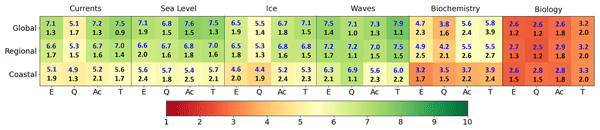
Stefania A. Ciliberti, Enrique Alvarez Fanjul, Jay Pearlman, Kirsten Wilmer-Becker, Pierre Bahurel, Fabrice Ardhuin, Alain Arnaud, Mike Bell, Segolene Berthou, Laurent Bertino, Arthur Capet, Eric Chassignet, Stefano Ciavatta, Mauro Cirano, Emanuela Clementi, Gianpiero Cossarini, Gianpaolo Coro, Stuart Corney, Fraser Davidson, Marie Drevillon, Yann Drillet, Renaud Dussurget, Ghada El Serafy, Katja Fennel, Marcos Garcia Sotillo, Patrick Heimbach, Fabrice Hernandez, Patrick Hogan, Ibrahim Hoteit, Sudheer Joseph, Simon Josey, Pierre-Yves Le Traon, Simone Libralato, Marco Mancini, Pascal Matte, Angelique Melet, Yasumasa Miyazawa, Andrew M. Moore, Antonio Novellino, Andrew Porter, Heather Regan, Laia Romero, Andreas Schiller, John Siddorn, Joanna Staneva, Cecile Thomas-Courcoux, Marina Tonani, Jose Maria Garcia-Valdecasas, Jennifer Veitch, Karina von Schuckmann, Liying Wan, John Wilkin, and Romane Zufic
State Planet, 1-osr7, 2, https://doi.org/10.5194/sp-1-osr7-2-2023, https://doi.org/10.5194/sp-1-osr7-2-2023, 2023
Matias Alday, Fabrice Ardhuin, Guillaume Dodet, and Mickael Accensi
Ocean Sci., 18, 1665–1689, https://doi.org/10.5194/os-18-1665-2022, https://doi.org/10.5194/os-18-1665-2022, 2022
Short summary
Short summary
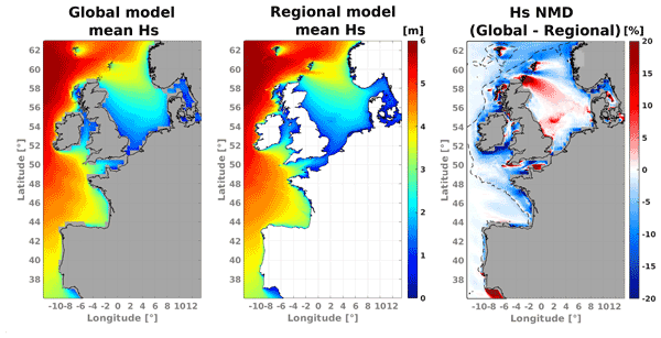
Obtaining accurate results from wave models in coastal regions is typically more difficult. This is due to the complex interactions between waves and the local environment characteristics like complex shorelines, sea bottom topography, the presence of strong currents, and other processes that include wave growth and decay. In the present study we analyze which elements can be adjusted and/or included in order to reduce errors in the modeled output.
Elena Gianotten, Meike F. Bos, Darshika Manral, Fabio Nauer, Erik Zettler, Lina A. Amaral-Zettler, and Erik van Sebille
EGUsphere, https://doi.org/10.5194/egusphere-2026-3097, https://doi.org/10.5194/egusphere-2026-3097, 2026
This preprint is open for discussion and under review for Biogeosciences (BG).
Short summary
Short summary
Widespread blooms of the seaweed Sargassum have caused large-scale inundation events in coastal Caribbean and African regions since 2011. Predicting the where these blooms appear, and how the Sargassum moves, depends on the interaction between ocean flow and biological growth. Here, we present a new computational framework for quick and easy simulation of Sargassum. The framework is particularly useful for testing the dependency of different growth models on the Sargassum fate.
Inès Mangolte, Sophie Cravatte, Alexandre Ganachaud, and Christophe Menkes
Ocean Sci., 22, 1937–1964, https://doi.org/10.5194/os-22-1937-2026, https://doi.org/10.5194/os-22-1937-2026, 2026
Short summary
Short summary
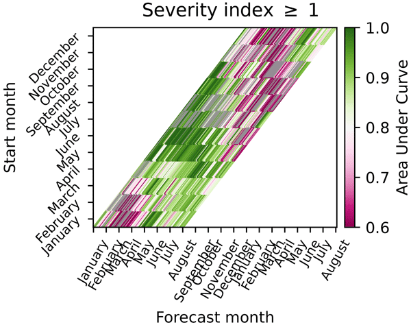
Marine heatwaves pose a serious threat to marine ecosystems that will become increasingly important with climate change. Here we show in the Southwest Pacific that dynamical forecasting systems are able to forecast long, large-scale marine heatwaves occurring in austral winter, but have less skill in predicting smaller, shorter events, and summer events. We discuss the implications for operational forecasts dedicated to help marine managers to prepare and mitigate some of their impacts.
Sara Pavan, Marco Bajo, Francesco Barbariol, Alvise Benetazzo, Silvio Davison, and Christian Ferrarin
EGUsphere, https://doi.org/10.5194/egusphere-2026-2774, https://doi.org/10.5194/egusphere-2026-2774, 2026
This preprint is open for discussion and under review for Natural Hazards and Earth System Sciences (NHESS).
Short summary
Short summary
We present the marine and coastal hazard estimation of Mediterranean cyclones during the period 1994–2020. The study shows which portion of extreme storm surge and waves is linked to cyclones in the Mediterranean Sea. Hazard estimation is performed according to sea level and waves based parameters. Results stress that it is challenging to identify the most hazardous Mediterranean cyclones in a comprehensive sense (i.e., accounting for all parameters), as well as the areas most exposed to hazard.
Anna Christina Hans, Rebecca Hummels, Peter Brandt, Franziska U. Schwarzkopf, and Stephan Juricke
EGUsphere, https://doi.org/10.5194/egusphere-2026-2983, https://doi.org/10.5194/egusphere-2026-2983, 2026
This preprint is open for discussion and under review for Ocean Science (OS).
Short summary
Short summary
We mimic an observational array at 11°S in an ocean model to assess its capability to compute the temporal variability of the Atlantic Meridional Overturning Circulation. The current approaches based on bottom pressure sensors and measurements of the boundary currents explain large parts of the transport variability. Improvements can be achieved by also considering temperature and salinity data, while the potential of self-calibrating pressure sensors and inverted echo sounders is limited.
Gwenael Jestin, Sara Fleury, Matthias Raynal, Marta Alves, Fanny Piras, Anaëlle Treboutte, François Boy, Inès Benabdillah, Louise Yu, and Gérald Dibarboure
EGUsphere, https://doi.org/10.5194/egusphere-2026-2569, https://doi.org/10.5194/egusphere-2026-2569, 2026
This preprint is open for discussion and under review for The Cryosphere (TC).
Short summary
Short summary
With its wide swath of 120 km, the SWOT altimeter offers unrivalled spatial and temporal coverage of the polar oceans. But frozen oceans are difficult to study because the ice cover only reveals the open ocean through cracks and polynyas. Whether studying the ice or the ocean, leads and floes must be distinguished. This classification is now available in the CNES L3 product at a resolution of 250 m. This paper outlines the methodology and improvements of the derived ice concentration maps.
Fabien Salmon, Pierre Rampal, Stéphanie Leroux, Timothy Williams, Einar Ólason, and Nicolas Barral
EGUsphere, https://doi.org/10.5194/egusphere-2026-1869, https://doi.org/10.5194/egusphere-2026-1869, 2026
This preprint is open for discussion and under review for Geoscientific Model Development (GMD).
Short summary
Short summary
Accurate modeling of sea ice dynamics is a major challenge for forecasting its future evolution and assessing its impact on climate change. This paper presents the parallelisation of state-of-the art sea-ice dynamics model NeXtSIM. The code was interfaced with a new parallel version of the remeshing library MMG. Validation and performance of the code are discussed. Simulations with a uniform 1km spatial resolution are run, which is unprecedented with this kind of lagrangian sea-ice models.
Chiara Favaretto, Francesco Barbariol, Alvise Benetazzo, Luigi Cavaleri, Francesco Marcello Falcieri, Christian Ferrarin, Rossella Ferretti, Stefano Menegon, Matteo Nastasi, Gianluca Redaelli, Antonio Ricchi, and Piero Ruol
EGUsphere, https://doi.org/10.5194/egusphere-2026-2285, https://doi.org/10.5194/egusphere-2026-2285, 2026
This preprint is open for discussion and under review for Natural Hazards and Earth System Sciences (NHESS).
Short summary
Short summary
Coastal flooding is becoming more frequent and damaging, but warnings often rely on single forecasts that miss important uncertainty. We developed and tested a new early warning approach that uses multiple weather scenarios to better describe possible flood outcomes, while reducing computing costs. Applied to severe storms in northern Italy, the method preserved key information and showed that reliable flood alerts can be produced efficiently, supporting practical early warning systems.
Maialen Irazoqui Apecechea, Angélique Melet, Melisa Menendez, Hector Lobeto, and Jonathan B. Valle-Rodriguez
Nat. Hazards Earth Syst. Sci., 26, 2269–2290, https://doi.org/10.5194/nhess-26-2269-2026, https://doi.org/10.5194/nhess-26-2269-2026, 2026
Short summary
Short summary
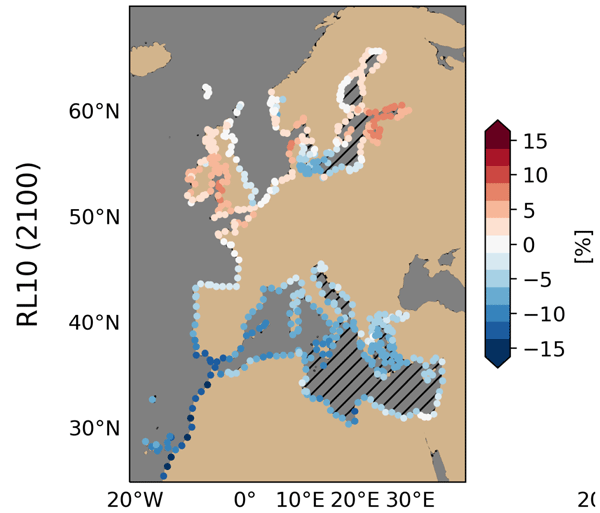
We applied a fast statistical model to estimate future extreme storm surges in Europe using data from 17 climate models – about twice as many as in past studies. Results show robust regional patterns – decreases in the Mediterranean and Moroccan coast, increases in the Irish Sea and Gulf of Finland – with high uncertainty in other areas. Out results increase our knowledge on future storm surge uncertainties, needed for informed coastal planning.
Achref Othmani, Annette Samuelsen, Jiping Xie, Laurent Bertino, Fabio Mangini, and Roshin Pappukutty Raj
EGUsphere, https://doi.org/10.5194/egusphere-2026-1520, https://doi.org/10.5194/egusphere-2026-1520, 2026
This preprint is open for discussion and under review for Geoscientific Model Development (GMD).
Short summary
Short summary
We developed a high-resolution (6–10 km) HYCOM-CICE configuration to better understand ocean and sea ice conditions in the Arctic and North Atlantic from 2009 to 2019. By comparing the model with available datasets, we found it reliably captures major patterns and seasonal changes. This can support forecasting, helping improve environmental monitoring and decision-making in regions sensitive to climate change.
Julien Brajard, Anton Korosov, Fabio Mangini, Richard Davy, and Yiguo Wang
EGUsphere, https://doi.org/10.5194/egusphere-2026-2318, https://doi.org/10.5194/egusphere-2026-2318, 2026
This preprint is open for discussion and under review for The Cryosphere (TC).
Short summary
Short summary
Small details in Arctic sea ice thickness, such as ridges, cracks and leads, are difficult to observe with satellites and are rarely represented in climate models, even though they strongly influence sea ice motion and its interaction with the climate system. In this study, we introduce an artificial intelligence method that reconstructs realistic small‑scale ice thickness features from coarse observations. The results show more accurate estimates and physically realistic sea ice patterns.
Alexander Kmoch, Wai Tik Chan, Guillaume Ameline, Justus Magin, Jean-Marc Delouis, Tina Odaka, Benoit Bovy, Anne Anne, and Evelyn Uuemaa
Int. Arch. Photogramm. Remote Sens. Spatial Inf. Sci., XLVIII-4-W20-2025, 45–52, https://doi.org/10.5194/isprs-archives-XLVIII-4-W20-2025-45-2026, https://doi.org/10.5194/isprs-archives-XLVIII-4-W20-2025-45-2026, 2026
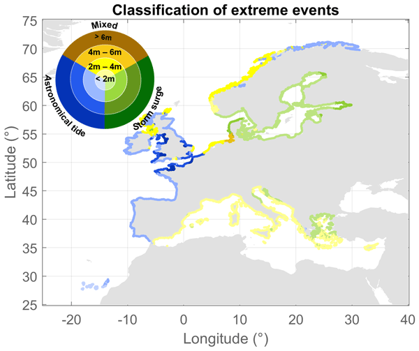
Camila Cotrim, Alexandra Toimil, Iñigo J. Losada, Melisa Menéndez, and Hector Lobeto
Nat. Hazards Earth Syst. Sci., 26, 1935–1954, https://doi.org/10.5194/nhess-26-1935-2026, https://doi.org/10.5194/nhess-26-1935-2026, 2026
Short summary
Short summary
Coastal storms place millions of people and infrastructures at risk. For this reason, we propose a method to estimate extreme total water levels in a consistent way across Europe, as this is the main indicator for coastal flooding. We consider local variations in tides, storm surges, waves, and beach slopes. We found that parts of Europe are affected differently, with tides being important on the Atlantic coast, storm surges in the Baltic Sea, and waves mattering most in the Mediterranean Sea.
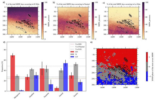
Bastien Pagli, Takeshi Izumo, Alexandre Barboni, Carla Chevillard, Cyril Dutheil, Raphaël Legrand, Christophe Menkes, Claire Rocuet, and Sophie Cravatte
Ocean Sci., 22, 1329–1352, https://doi.org/10.5194/os-22-1329-2026, https://doi.org/10.5194/os-22-1329-2026, 2026
Short summary
Short summary
Marine heatwaves—periods of unusually warm ocean temperatures—are becoming more frequent and intense with climate change. These events can harm marine ecosystems, especially in vulnerable regions like French Polynesia. Here, we used satellite sea surface temperature data and ocean reanalysis to characterize past events. We investigated their characteristics, variability linked to El Niño Southern Oscillation, and the physical mechanisms driving their onset and decay across the region.
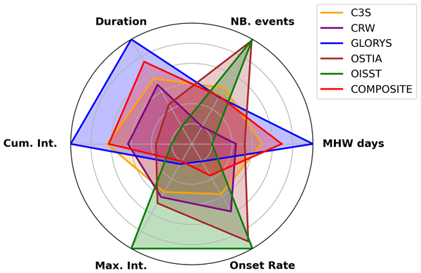
Carla Chevillard, Romain Le Gendre, Christophe Menkes, Takeshi Izumo, Bastien Pagli, Simon Van Wynsberge, and Sophie Cravatte
Ocean Sci., 22, 1213–1236, https://doi.org/10.5194/os-22-1213-2026, https://doi.org/10.5194/os-22-1213-2026, 2026
Short summary
Short summary
To detect past marine heatwaves events and analyse their characteristics, scientists use one of the available sea surface temperature products, relying on different data ingested and procedures. Here, we compare marine heatwaves statistics computed using six products in the tropical Pacific over 1993–2021. We highlight significant differences and provide uncertainties. Our results advocate for the use of multiple products in marine heatwaves studies to increase the robustness of the conclusions.
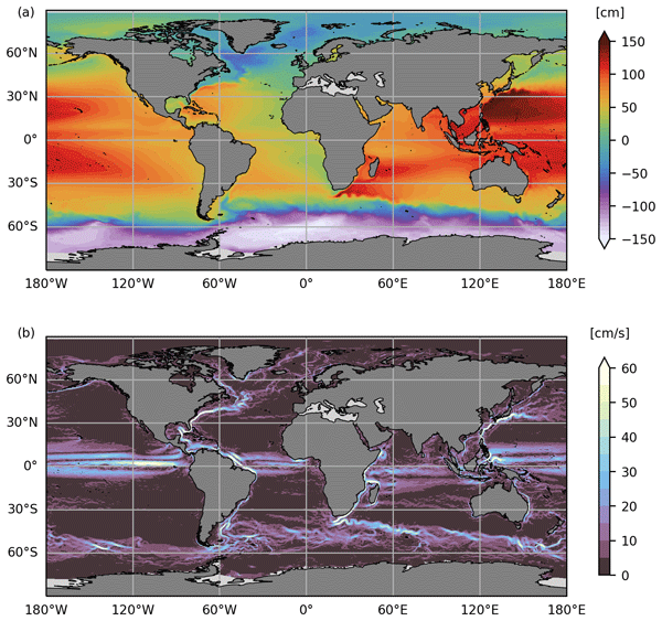
Solène Jousset, Sandrine Mulet, Eric Greiner, John Wilkin, Lien Vidar, Léon Chafik, Roshin Raj, Antonio Bonaduce, Nicolas Picot, and Gérald Dibarboure
Earth Syst. Sci. Data, 18, 2285–2303, https://doi.org/10.5194/essd-18-2285-2026, https://doi.org/10.5194/essd-18-2285-2026, 2026
Short summary
Short summary
Satellite altimetry has revolutionized ocean observation, making it possible to track sea level with very good spatio-temporal coverage. However, only sea level anomalies are retrieved; to monitor the entire ocean signal, mean dynamic topography (MDT) must be added to these anomalies. In this study, an evaluation of the CNES-CLS22 MDT shows significant improvements in the Arctic. Over the globe, this new solution represents an incremental update to previous CNES-CLS18 MDT.
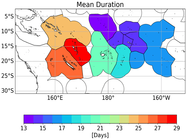
Shilpa Lal, Sophie Cravatte, Christophe Menkes, Jed Macdonald, Romain Le Gendre, Ines Mangolte, Cyril Dutheil, Neil J. Holbrook, and Simon Nicol
Ocean Sci., 22, 1023–1049, https://doi.org/10.5194/os-22-1023-2026, https://doi.org/10.5194/os-22-1023-2026, 2026
Short summary
Short summary
This paper characterizes historical (1981–2023) marine heatwaves in the tropical southwestern Pacific, where they pose a challenge for marine resource dependent Islands. Heatwaves are distinguished as a function of their spatial extent, signature at the coast, and seasonality, to allow a better understanding of their impacts on ecosystems. Marine heatwaves are getting longer and more frequent, with greater spatial extents. Our results aim to inform the Pacific Islands on their vulnerability.
Juliette Gamot, Antoine Delepoulle, Francesco Nencioli, Marie-Isabelle Pujol, and Gérald Dibarboure
Earth Syst. Sci. Data Discuss., https://doi.org/10.5194/essd-2026-108, https://doi.org/10.5194/essd-2026-108, 2026
Preprint under review for ESSD
Short summary
Short summary
Mesoscale eddies are rotating ocean features that play a key role in transporting heat, salt, and biological material. This study presents a new global dataset derived from satellite observations to track these eddies and identify when they merge or split. By organizing them into interaction networks, we show that such events are frequent and strongly influence eddy evolution, leading to a more realistic description of ocean circulation.
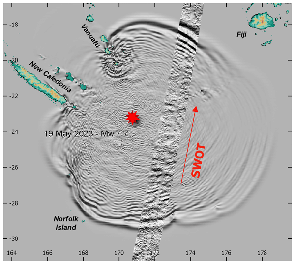
Jean H. M. Roger, Yannice Faugère, Hélène Hébert, Antoine Delepoulle, and Gérald Dibarboure
Nat. Hazards Earth Syst. Sci., 26, 943–954, https://doi.org/10.5194/nhess-26-943-2026, https://doi.org/10.5194/nhess-26-943-2026, 2026
Short summary
Short summary
Deployed in 2022, the SWOT (Surface Water Ocean Topography) satellite was flying over the Southwest Pacific on 19 May 2023 when it recorded the tsunami triggered by a magnitude 7.7 earthquake south of the Vanuatu arc. For the very first time, it provided a 2D image of a tsunami wavefield along a straight path. Comparison with numerical tsunami simulations reveals good phase agreement between the modeled wavefield and the SWOT record, but the simulated amplitudes are lower than the measurements.
Issufo Halo, Tarron Lamont, Michael Hart-Davis, Pierrick Penven, Isabelle Ansorge, Chris Reason, Bjorn Backeberg, Siren Rühs, Erik van Sebille, Christo Whittle, Annette Samuelsen, Johnny Johannessen, Tamaryn Morris, Marjolaine Krug, Juliet Hermes, Marek Ostrowski, Sheveenah Taukoor, and Babatunde Abiodun
EGUsphere, https://doi.org/10.5194/egusphere-2025-6573, https://doi.org/10.5194/egusphere-2025-6573, 2026
Short summary
Short summary
This review synthesizes two decades of research on the Greater Agulhas Current System, a major ocean current influencing climate, weather and marine life around southern Africa and beyond. Using improved observations, satellites, and computer models, we show how this system transports properties between oceans, affects rainfall and climate patterns, and marine ecosystems. The findings highlight its global climate importance and the need for sustained monitoring to better predict future change.
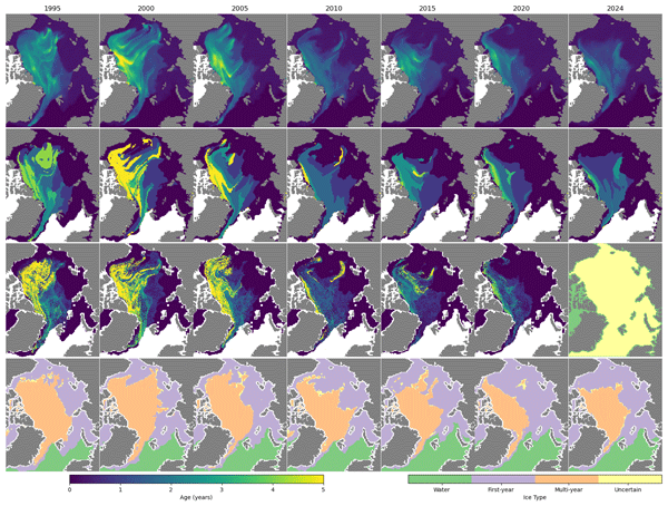
Anton Korosov, Léo Edel, Heather Regan, Thomas Lavergne, Signe Aaboe, and Emily Jane Down
Earth Syst. Sci. Data, 18, 721–740, https://doi.org/10.5194/essd-18-721-2026, https://doi.org/10.5194/essd-18-721-2026, 2026
Short summary
Short summary
We present a new long-term record of Arctic sea ice age spanning from 1991 to 2024. Using satellite data and a new tracking method, it maps fractions of sea ice from first- to sixth-year and includes uncertainty estimates. The dataset shows a decline in older ice and more first-year ice, it agrees well with buoy data, and supports Arctic monitoring, climate research, navigation, and model evaluation.
Lohenn Fiol, Stephanie Leroux, Pierre Rampal, and Jean-Michel Brankart
EGUsphere, https://doi.org/10.5194/egusphere-2025-6379, https://doi.org/10.5194/egusphere-2025-6379, 2026
Short summary
Short summary
We examine how uncertainty in the initial position of sea ice features (leads, ridges), affects daily-to-weekly winter sea-ice forecasts. Using ensemble simulations with a sea ice–ocean model, we compare two formulations of sea ice mechanics. We show that pack-ice dynamics are highly sensitive to this choice: one formulation strongly amplifies small initial errors, while the other damps them. Our results highlight the need for ensemble forecasts to capture uncertainty and risks in the Arctic.
Cécile Kocha, Marine Liévin, Yann Pageot, Clémence Rubin, Victor Quet, Franck Octau, Marie-Isabelle Pujol, Pierre Prandi, Sabine Philipps, Gerald Dibarboure, Isabelino Denis, Carolina Nogueira Loddo, and François Bignalet-Cazalet
Earth Syst. Sci. Data Discuss., https://doi.org/10.5194/essd-2025-604, https://doi.org/10.5194/essd-2025-604, 2026
Preprint under review for ESSD
Short summary
Short summary
30 years of satellite altimetry data were reprocessed in 2024, using state-of-the-art research algorithms and models. The so-called DT-2024 sea level dataset provides a homogenous and consistent set of observations from 15 satellites and 5 climate reference altimeters. This new dataset is shown to improve mesoscale quality and consistency, particularly over coastal and polar areas, as well as the long-term stability for climate research.
Meike F. Bos, Irina I. Rypina, Larry J. Pratt, and Erik van Sebille
EGUsphere, https://doi.org/10.5194/egusphere-2026-64, https://doi.org/10.5194/egusphere-2026-64, 2026
Short summary
Short summary
Macroplastic items in the ocean can move differently than the water surrounding them, because their size and density are different than that of water. We investigate how to implement this effect for macroplastic items in simulations in the North West European Shelf region. For this region we find that the large drag force makes the macroplastics trajectories very closely follow the water itself, meaning that simulating macroplastic is simpler than previously expected.
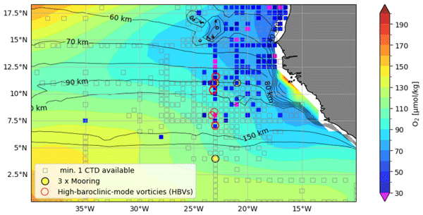
Florian Schütte, Johannes Hahn, Ivy Frenger, Arne Bendinger, Ahmad Fehmi Dilmahamod, Marco Schulz, and Peter Brandt
Ocean Sci., 22, 119–143, https://doi.org/10.5194/os-22-119-2026, https://doi.org/10.5194/os-22-119-2026, 2026
Short summary
Short summary
We found extreme drops in oxygen levels in the tropical Atlantic linked to surprisingly long-lived, small subsurface eddies. These eddies are hidden beneath the surface (undetectable by satellites) and are unusually stable, even in the highly dynamic ocean near the equator. Using long-term measurements and computer models, we show that these features can strongly influence oxygen supply and potentially impact marine ecosystems.
Erik van Sebille, Celine Weel, Rens Vliegenthart, and Mark Bos
Geosci. Commun., 9, 69–86, https://doi.org/10.5194/gc-9-69-2026, https://doi.org/10.5194/gc-9-69-2026, 2026
Short summary
Short summary
Many climate scientists intuitively fear their credibility decreases when they engage in advocacy. We find that the opposite is the case. By surveying almost 1000 Dutch adults, we found that the credibility of a fictional climate scientists who wrote an article about the greening of gardens was higher when that text included advocacy statements, compared to when it was
neutral. This is because personalization increases the goodwill of readers for the academic who writes a text.
Noémie Lalau, Michaël Ablain, Thomas Vaujour, François Boy, Gerald Dibarboure, and Alejandro Egido
EGUsphere, https://doi.org/10.5194/egusphere-2025-6364, https://doi.org/10.5194/egusphere-2025-6364, 2026
Short summary
Short summary
We investigated how to maintain continuous sea level measurements between current Sentinel-3 satellites and the upcoming Sentinel-3 Next Generation Topography mission. Because of new satellite designs, a 4-hour delay will exists between observations during the calibration phase. By simulating this lag, we found that, despite increased uncertainty, reliable calibration is possible. Extending this phase to one year ensures a stable, long-term record for climate and ocean monitoring.
Jimena Medina-Rubio, Madlene Nussbaum, Ton S. van den Bremer, and Erik van Sebille
Ocean Sci., 22, 49–74, https://doi.org/10.5194/os-22-49-2026, https://doi.org/10.5194/os-22-49-2026, 2026
Short summary
Short summary
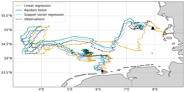
We study how tides, wind, and waves interact at the ocean surface by tracking ultra-thin drifters released in the southern North Sea for two months. Using model data together with data-driven machine learning models, we determine the relative contribution of each forcing mechanism in driving the drifters' velocity and improve the prediction of their trajectories. We also test the generalisability of this method by applying it to the same drifters in the Tyrrhenian Sea.
Marc Emanuel Schneiter, Rolf Hut, and Erik Van Sebille
EGUsphere, https://doi.org/10.5194/egusphere-2025-6170, https://doi.org/10.5194/egusphere-2025-6170, 2025
Short summary
Short summary
We study land-water transitions of 24 small floating position-trackers that approximately mimic floating plastic litter. We describe how to automatically identify such transitions from recorded tracks, and we characterize our observations with respect to sea and wind conditions. The insights can be integrated in model simulations and used for the planning of beach cleanups. We released the trackers in the Wadden Sea, a shallow body of water that is strongly influenced by tides and wind.
Joelle Habib, Lars Stemmann, Alexandre Accardo, Alberto Baudena, Franz Philip Tuchen, Peter Brandt, and Rainer Kiko
Biogeosciences, 22, 7985–8003, https://doi.org/10.5194/bg-22-7985-2025, https://doi.org/10.5194/bg-22-7985-2025, 2025
Short summary
Short summary
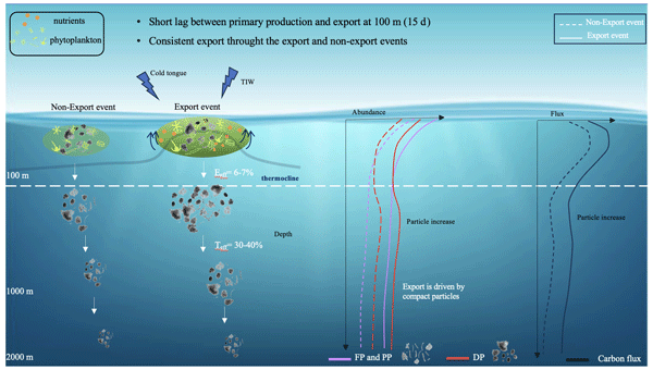
This study investigates how carbon moves from the ocean surface to the depths in the equatorial Atlantic, contributing to long-term carbon storage. Using an Argo float equipped with a camera, we captured two periods with major carbon export events. By identifying particle types and their sinking behaviors, we found that smaller, compact particles are key drivers of carbon transport. Our findings underscore the value of using imaging tools on autonomous platforms in tracking carbon sequestration.
Jean Rabault, Trygve Halsne, Ana Carrasco, Anton Korosov, Joey Voermans, Patrik Bohlinger, Jens Boldingh Debernard, Malte Müller, Øyvind Breivik, Takehiko Nose, Gaute Hope, Fabrice Collard, Sylvain Herlédan, Tsubasa Kodaira, Nick Hughes, Qin Zhang, Kai Håkon Christensen, Alexander Babanin, Lars Willas Dreyer, Cyril Palerme, Lotfi Aouf, Konstantinos Christakos, Atle Jensen, Johannes Röhrs, Aleksey Marchenko, Graig Sutherland, Trygve Kvåle Løken, and Takuji Waseda
The Cryosphere, 19, 6229–6260, https://doi.org/10.5194/tc-19-6229-2025, https://doi.org/10.5194/tc-19-6229-2025, 2025
Short summary
Short summary
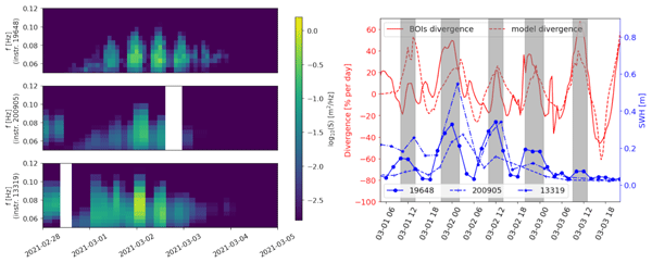
We observe strongly modulated waves-in-ice significant wave height using buoys deployed East of Svalbard. We show that these observations likely cannot be explained by wave-current interaction or tide-induced modulation alone. We also demonstrate a strong correlation between the waves height modulation, and the rate of sea ice convergence. Therefore, our data suggest that the rate of sea ice convergence and divergence may modulate wave in ice energy dissipation.
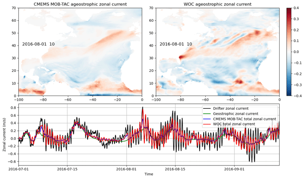
Clément Ubelmann, J. Thomas Farrar, Bertrand Chapron, Lucile Gaultier, Laura Gomez-Navarro, Marie-Hélène Rio, and Gérald Dibarboure
Ocean Sci., 21, 2915–2928, https://doi.org/10.5194/os-21-2915-2025, https://doi.org/10.5194/os-21-2915-2025, 2025
Short summary
Short summary
This study models wind-driven ocean currents using observed wind stress and an empirically estimated impulse response function based on drifting buoys. By convolving this function with wind forcing from ERA5, the estimates align well with independent observations across latitudes. Additionally, the response function serves as a valuable indicator of subsurface properties.
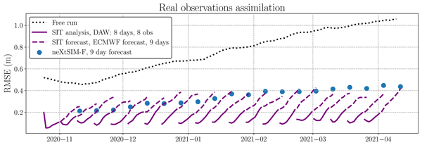
Charlotte Durand, Tobias Sebastian Finn, Alban Farchi, Marc Bocquet, Julien Brajard, and Laurent Bertino
The Cryosphere, 19, 5613–5637, https://doi.org/10.5194/tc-19-5613-2025, https://doi.org/10.5194/tc-19-5613-2025, 2025
Short summary
Short summary
This paper presents a four-dimensional variational data assimilation system based on a neural network emulator for sea-ice thickness, learned from neXtSIM (neXt generation Sea Ice Model) simulation outputs. Testing with simulated and real observation retrievals, the system improves forecasts and bias error, performing comparably to operational methods, demonstrating the promise of sea-ice data-driven data assimilation systems.
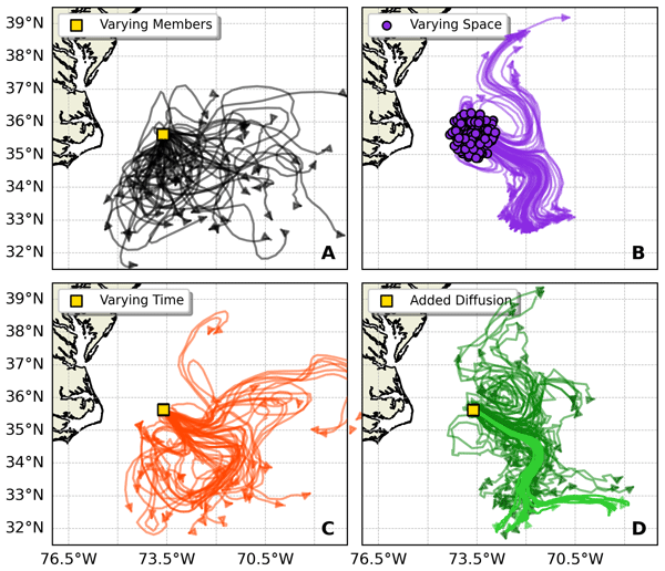
Claudio M. Pierard, Siren Rühs, Laura Gómez-Navarro, Michael Charles Denes, Florian Meirer, Thierry Penduff, and Erik van Sebille
Nonlin. Processes Geophys., 32, 411–438, https://doi.org/10.5194/npg-32-411-2025, https://doi.org/10.5194/npg-32-411-2025, 2025
Short summary
Short summary
Particle-tracking simulations compute how ocean currents transport material. However, initializing these simulations is often ad hoc. Here, we explore how two different strategies (releasing particles over space or over time) compare. Specifically, we compare the variability in particle trajectories to the variability of particles computed in a 50-member ensemble simulation. We find that releasing the particles over 20 weeks gives variability that is most like that in the ensemble.
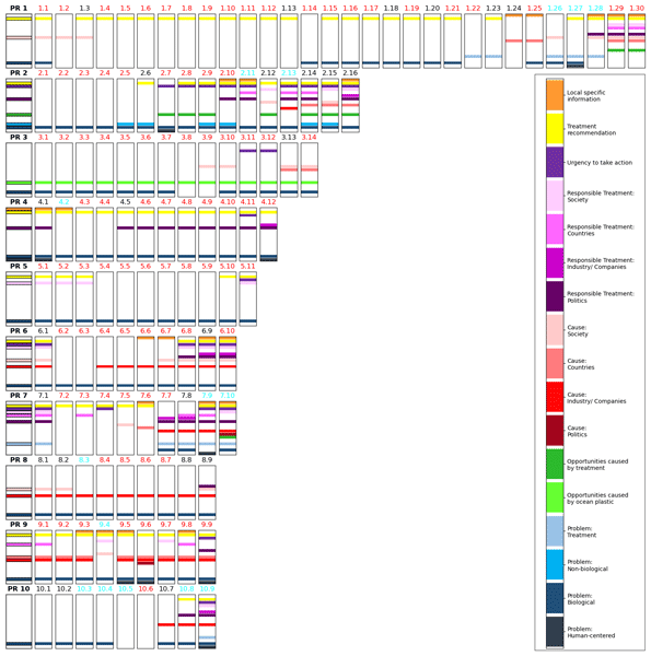
Aike Vonk, Mark Bos, and Erik van Sebille
Geosci. Commun., 8, 297–317, https://doi.org/10.5194/gc-8-297-2025, https://doi.org/10.5194/gc-8-297-2025, 2025
Short summary
Short summary
Research institutes communicate scientific findings through press releases, which journalists use to write news articles. We examined how journalists use content from press releases about ocean plastic research. Our findings show that they closely follow the press releases story, primarily quoting involved scientists without seeking external perspectives. Causing the focus to stay on researchers, personalizing science rather than addressing the broader societal dimensions of plastic pollution.
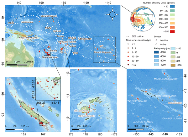
Romain Le Gendre, David Varillon, Sylvie Fiat, Régis Hocdé, Antoine de Ramon N'Yeurt, Serge Andréfouët, Jérôme Aucan, Sophie Cravatte, Maxime Duphil, Alexandre Ganachaud, Baptiste Gaudron, Elodie Kestenare, Vetea Liao, Bernard Pelletier, Alexandre Peltier, Anne-Lou Schaefer, Thomas Trophime, Simon Van Wynsberge, Yves Dandonneau, Michel Allenbach, and Christophe Menkes
Earth Syst. Sci. Data, 17, 5277–5301, https://doi.org/10.5194/essd-17-5277-2025, https://doi.org/10.5194/essd-17-5277-2025, 2025
Short summary
Short summary
Due to ocean warming, coral reef ecosystems are strongly impacted by dystrophic events and corals experiencing increasing frequencies of bleaching events. In situ observation remains the best alternative for accurate characterization of trends and extremes in these shallow environments. This paper presents the coastal temperature dataset of the ReefTEMPS monitoring network, which spreads over multiple Pacific Island countries and territories (PICTs) in the western and central South Pacific.
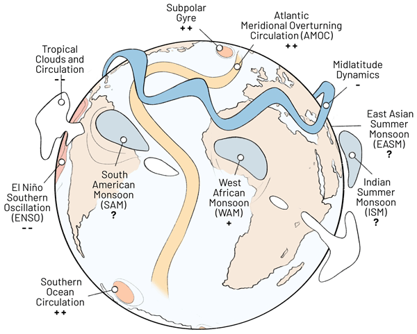
Sina Loriani, Yevgeny Aksenov, David I. Armstrong McKay, Govindasamy Bala, Andreas Born, Cristiano Mazur Chiessi, Henk A. Dijkstra, Jonathan F. Donges, Sybren Drijfhout, Matthew H. England, Alexey V. Fedorov, Laura C. Jackson, Kai Kornhuber, Gabriele Messori, Francesco S. R. Pausata, Stefanie Rynders, Jean-Baptiste Sallée, Bablu Sinha, Steven C. Sherwood, Didier Swingedouw, and Thejna Tharammal
Earth Syst. Dynam., 16, 1611–1653, https://doi.org/10.5194/esd-16-1611-2025, https://doi.org/10.5194/esd-16-1611-2025, 2025
Short summary
Short summary
In this work, we draw on palaeo-records, observations, and modelling studies to review tipping points in the ocean overturning circulations, monsoon systems, and global atmospheric circulations. We find indications for tipping in the ocean overturning circulations and the West African monsoon, with potentially severe impacts on the Earth system and humans. Tipping in the other considered systems is regarded as conceivable but is currently not sufficiently supported by evidence.
Roshin P. Raj, Vidar S. Lien, Sourav Chatterjee, Saradhy Surendran, Antonio Bonaduce, and Laurent Bertino
State Planet Discuss., https://doi.org/10.5194/sp-2025-18, https://doi.org/10.5194/sp-2025-18, 2025
Revised manuscript under review for SP
Short summary
Short summary
Dense water formed and exiting from the Barents Sea constitutes an important part of the global ocean circulation. Considering the significant impact of salinity changes in dense water formation, we investigate the salinity changes in the Barents Sea during the past 3 decades. Our results highlight the recent freshening and its drivers in the northern and southern Barents Sea and show its impact on the density of the waters exiting the Barents Sea.
Nefeli Makrygianni, Ségolène Berthou, David L. A. Flack, Cindy Lebeaupin Brossier, Jonathan Beuvier, Juan Manuel Castillo, Emiliano Renzi, Clare O’Neill, Daniel Peláez-Zapata, Frederic Dias, Huw Lewis, and Diego Bruciaferri
EGUsphere, https://doi.org/10.5194/egusphere-2025-3555, https://doi.org/10.5194/egusphere-2025-3555, 2025
Short summary
Short summary
Meteotsunamis are rare but dangerous anomalous waves triggered by atmospheric disturbances, they are not currently forecast in Northwest Europe. We analysed the strongest recorded event on June 18, 2022, which reached 1 m amplitude. We showed high-resolution, high-frequency coupled models can predict such events up to three days ahead and help better understand their atmospheric triggers. These models, together with improved observations, can enhance early warnings and coastal safety.
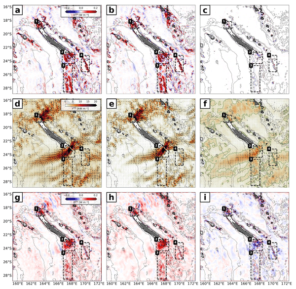
Arne Bendinger, Sophie Cravatte, Lionel Gourdeau, Clément Vic, and Florent Lyard
Ocean Sci., 21, 1943–1966, https://doi.org/10.5194/os-21-1943-2025, https://doi.org/10.5194/os-21-1943-2025, 2025
Short summary
Short summary
Temporal variability of the semidiurnal internal tide around New Caledonia is investigated using regional modeling. An important contribution to temporal variability not linked to the spring–neap tide cycle is due to the presence of mesoscale eddies both at the generation sites and in the propagation direction. The incoherent tide has a widespread signature in sea surface height (SSH), challenging the SSH observability of mesoscale to submesoscale dynamics.
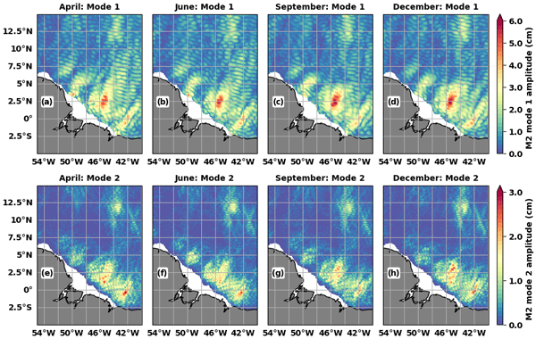
Michel Tchilibou, Simon Barbot, Loren Carrere, Ariane Koch-Larrouy, Gérald Dibarboure, and Clément Ubelmann
Ocean Sci., 21, 1469–1486, https://doi.org/10.5194/os-21-1469-2025, https://doi.org/10.5194/os-21-1469-2025, 2025
Short summary
Short summary
MIOST24 (Multivariate Inversion of Ocean Surface Topography 2024) annual and monthly internal tide (IT) atlases, based on 25 years of altimetry data and an updated wavelength database, are presented for the Indo-Philippine archipelago and the Amazon shelf. The atlases show monthly IT variability and a better correction of IT in altimetry data than with MIOST22 (MIOST 2022) and HRET (High-Resolution Empirical Tide). The results support the development of a global MIOST24.
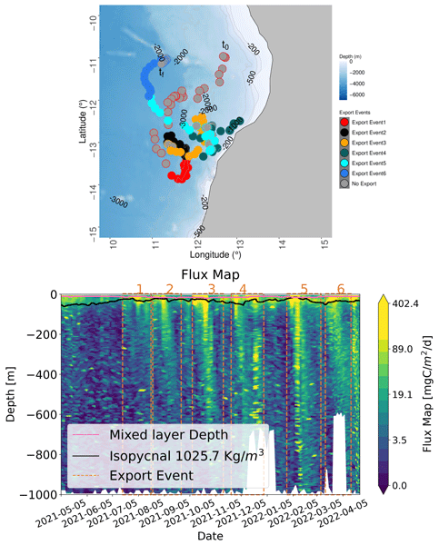
Yawouvi Dodji Soviadan, Miriam Beck, Joelle Habib, Alberto Baudena, Laetitia Drago, Alexandre Accardo, Remi Laxenaire, Sabrina Speich, Peter Brandt, Rainer Kiko, and Stemmann Lars
Biogeosciences, 22, 3485–3501, https://doi.org/10.5194/bg-22-3485-2025, https://doi.org/10.5194/bg-22-3485-2025, 2025
Short summary
Short summary
Key parameters representing the gravity flux in global models are sinking speed and vertical attenuation of exported material. We calculate, for the first time, these parameters in situ in the ocean for six intermittent blooms followed by export events using high-resolution (3 d) time series of 0–1000 m depth profiles from imaging sensors mounted on an Argo float. We show that sinking speed depends not only on size but also on the morphology of the particles, with density being an important property.
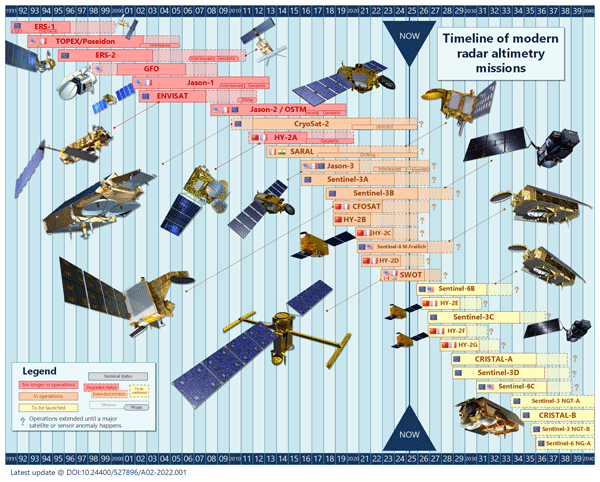
Pierre-Yves Le Traon, Gérald Dibarboure, Jean-Michel Lellouche, Marie-Isabelle Pujol, Mounir Benkiran, Marie Drevillon, Yann Drillet, Yannice Faugère, and Elisabeth Remy
Ocean Sci., 21, 1329–1347, https://doi.org/10.5194/os-21-1329-2025, https://doi.org/10.5194/os-21-1329-2025, 2025
Short summary
Short summary
By providing all weather, global, and real-time observations of sea level, a key variable to constrain ocean analysis and forecasting systems, satellite altimetry has had a profound impact on the development of operational oceanography. This paper provides an overview of the development and evolution of satellite altimetry and operational oceanography over the past 20 years from the launch of Jason-1 in 2001 to the launch of SWOT (Surface Water and Ocean Topography) in 2022.
Baylor Fox-Kemper, Patricia DeRepentigny, Anne Marie Treguier, Christian Stepanek, Eleanor O’Rourke, Chloe Mackallah, Alberto Meucci, Yevgeny Aksenov, Paul J. Durack, Nicole Feldl, Vanessa Hernaman, Céline Heuzé, Doroteaciro Iovino, Gaurav Madan, André L. Marquez, François Massonnet, Jenny Mecking, Dhrubajyoti Samanta, Patrick C. Taylor, Wan-Ling Tseng, and Martin Vancoppenolle
EGUsphere, https://doi.org/10.5194/egusphere-2025-3083, https://doi.org/10.5194/egusphere-2025-3083, 2025
Short summary
Short summary
The earth system model variables needed for studies of the ocean and sea ice are prioritized and requested.
Hélène Etienne, Clément Ubelmann, Fabrice Ardhuin, and Gérald Dibarboure
EGUsphere, https://doi.org/10.5194/egusphere-2025-2890, https://doi.org/10.5194/egusphere-2025-2890, 2025
Preprint archived
Short summary
Short summary
This study analyzes near-inertial oscillations (NIOs) in ocean surface currents using drifter data and the LLC2160 ocean-atmosphere model. It finds that NIOs have a typical spatial decorrelation scale around 100 km, varying with latitude. The model accurately captures these patterns, supporting the ODYSEA concept mission's goal to measure surface currents via Doppler radar and reduce NIO-related data aliasing for better ocean monitoring.
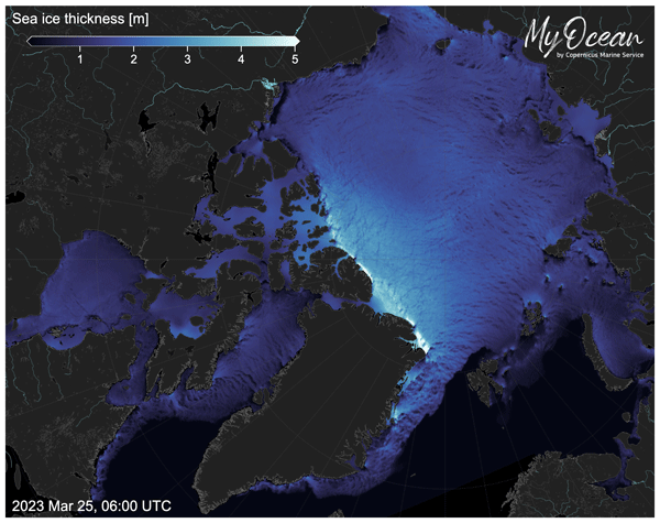
Laurent Bertino, Patrick Heimbach, Ed Blockley, and Einar Ólason
State Planet, 5-opsr, 14, https://doi.org/10.5194/sp-5-opsr-14-2025, https://doi.org/10.5194/sp-5-opsr-14-2025, 2025
Short summary
Short summary
Forecasts of sea ice are in high demand in the polar regions, and they are also quickly improving and becoming more easily accessible to non-experts. We provide here a brief status of the short-term forecasting services – typically 10 d ahead – and an outlook of their upcoming developments.
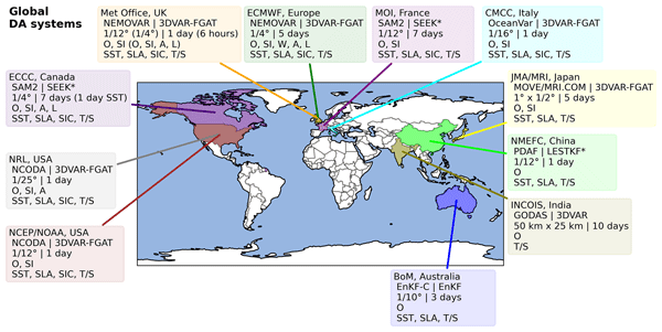
Matthew J. Martin, Ibrahim Hoteit, Laurent Bertino, and Andrew M. Moore
State Planet, 5-opsr, 9, https://doi.org/10.5194/sp-5-opsr-9-2025, https://doi.org/10.5194/sp-5-opsr-9-2025, 2025
Short summary
Short summary
Observations of the ocean from satellites and platforms in the ocean are combined with information from computer models to produce predictions of how the ocean temperature, salinity, and currents will evolve over the coming days and weeks and to describe how the ocean has evolved in the past. This paper summarises the methods used to produce these ocean forecasts at various centres around the world and outlines the practical considerations for implementing such forecasting systems.
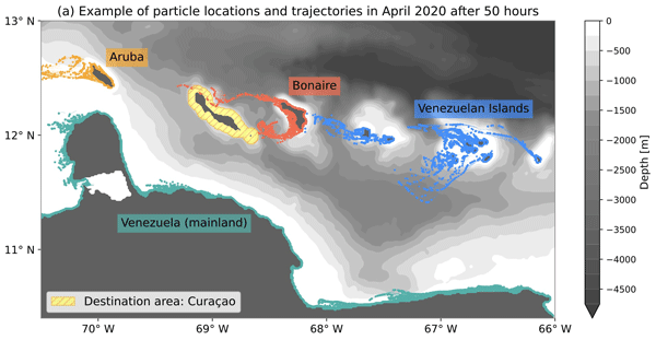
Vesna Bertoncelj, Furu Mienis, Paolo Stocchi, and Erik van Sebille
Ocean Sci., 21, 945–964, https://doi.org/10.5194/os-21-945-2025, https://doi.org/10.5194/os-21-945-2025, 2025
Short summary
Short summary
This study explores ocean currents around Curaçao and how land-derived substances like pollutants and nutrients travel in the water. Most substances move northwest, following the main current, but at times, ocean eddies spread them in other directions. This movement may link polluted areas to pristine coral reefs, impacting marine ecosystems. Understanding these patterns helps inform conservation and pollution management around Curaçao.
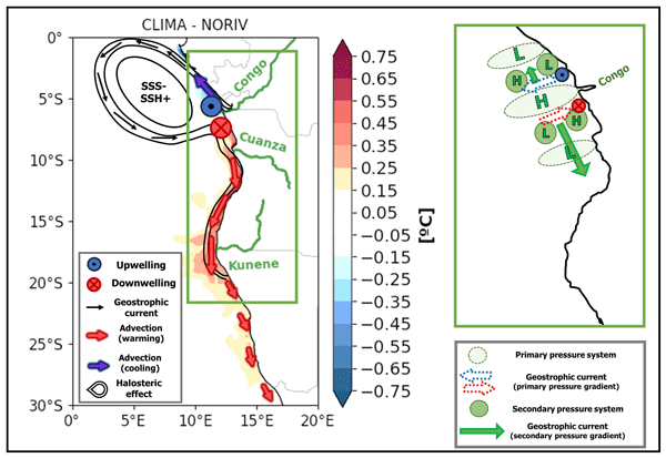
Léo C. Aroucha, Joke F. Lübbecke, Peter Brandt, Franziska U. Schwarzkopf, and Arne Biastoch
Ocean Sci., 21, 661–678, https://doi.org/10.5194/os-21-661-2025, https://doi.org/10.5194/os-21-661-2025, 2025
Short summary
Short summary
The west African coastal region sustains highly productive fisheries and marine ecosystems influenced by sea surface temperature. We use oceanic models to show that the freshwater input from land to ocean strengthens a surface northward (southward) coastal current north (south) of the Congo River mouth, promoting a transfer of cooler (warmer) waters to north (south) of the Congo discharge location. We highlight the significant impact of river discharge on ocean temperatures and circulation.
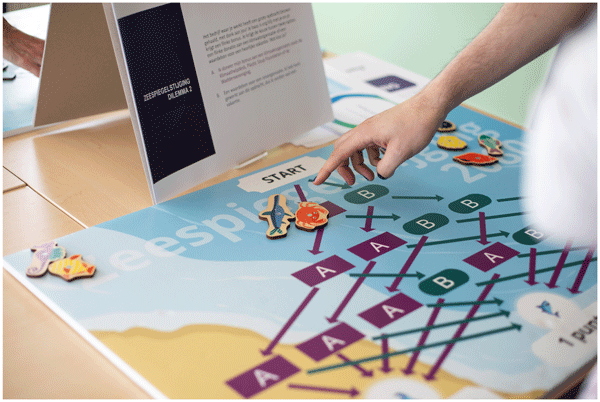
Nieske Vergunst, Tugce Varol, and Erik van Sebille
Geosci. Commun., 8, 67–80, https://doi.org/10.5194/gc-8-67-2025, https://doi.org/10.5194/gc-8-67-2025, 2025
Short summary
Short summary
We developed and evaluated a board game about sea level rise to engage young adults. We found that the game positively influenced participants' perceptions of their impact on sea level rise, regardless of their prior familiarity with science. This study suggests that interactive and relatable activities can effectively engage audiences on climate issues, highlighting the potential for similar approaches in public science communication.

Léo Edel, Jiping Xie, Anton Korosov, Julien Brajard, and Laurent Bertino
The Cryosphere, 19, 731–752, https://doi.org/10.5194/tc-19-731-2025, https://doi.org/10.5194/tc-19-731-2025, 2025
Short summary
Short summary
This study developed a new method to estimate Arctic sea ice thickness from 1992 to 2010 using a combination of machine learning and data assimilation. By training a machine learning model on data from 2011 to 2022, past errors in sea ice thickness can be corrected, leading to improved estimations. This approach provides insights into historical changes in sea ice thickness, showing a notable decline from 1992 to 2022, and offers a valuable resource for future studies.
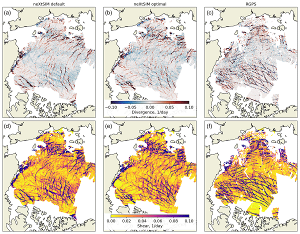
Anton Korosov, Yue Ying, and Einar Ólason
Geosci. Model Dev., 18, 885–904, https://doi.org/10.5194/gmd-18-885-2025, https://doi.org/10.5194/gmd-18-885-2025, 2025
Short summary
Short summary
We have developed a new method to improve the accuracy of sea ice models, which predict how ice moves and deforms due to wind and ocean currents. Traditional models use parameters that are often poorly defined. The new approach uses machine learning to fine-tune these parameters by comparing simulated ice drift with satellite data. The method identifies optimal settings for the model by analysing patterns in ice deformation. This results in more accurate simulations of sea ice drift forecasting.
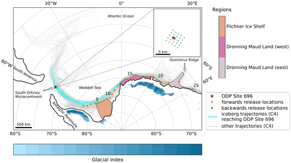
Mark V. Elbertsen, Erik van Sebille, and Peter K. Bijl
Clim. Past, 21, 441–464, https://doi.org/10.5194/cp-21-441-2025, https://doi.org/10.5194/cp-21-441-2025, 2025
Short summary
Short summary
This work verifies the remarkable finds of late Eocene Antarctic-sourced iceberg-rafted debris on the South Orkney Microcontinent. We find that these icebergs must have been on the larger end of the size scale compared to today’s icebergs due to faster melting in the warmer Eocene climate. The study was performed using a high-resolution model in which individual icebergs were followed through time.
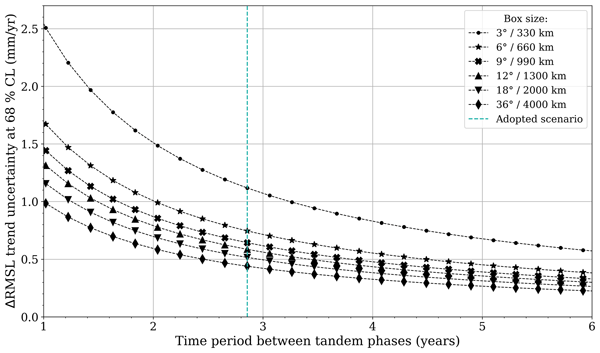
Michaël Ablain, Noémie Lalau, Benoit Meyssignac, Robin Fraudeau, Anne Barnoud, Gérald Dibarboure, Alejandro Egido, and Craig Donlon
Ocean Sci., 21, 343–358, https://doi.org/10.5194/os-21-343-2025, https://doi.org/10.5194/os-21-343-2025, 2025
Short summary
Short summary
This study proposes a novel cross-validation method to assess the instrumental stability in sea level trends. The method involves implementing a second tandem flight phase between two successive altimeter missions a few years after the first phase. The trend in systematic instrumental differences made during the two tandem phases can be estimated below ± 0.1 mm yr-1 (16–84 % confidence level) on a global scale for time intervals between the tandem phases of 4 years or more.
Einar Ólason, Guillaume Boutin, Timothy Williams, Anton Korosov, Heather Regan, Jonathan Rheinlænder, Pierre Rampal, Daniela Flocco, Abdoulaye Samaké, Richard Davy, Timothy Spain, and Sean Chua
EGUsphere, https://doi.org/10.5194/egusphere-2024-3521, https://doi.org/10.5194/egusphere-2024-3521, 2025
Short summary
Short summary
This paper introduces a new version of the neXtSIM sea-ice model. NeXtSIM is unique among sea-ice models in how it represents sea-ice dynamics, focusing on features such as cracks and ridges and how these impact interactions between the atmosphere and ocean where sea ice is present. The new version introduces some physical parameterisations and model options detailed and explained in the paper. Following the paper's publication, the neXtSIM code will be released publicly for the first time.
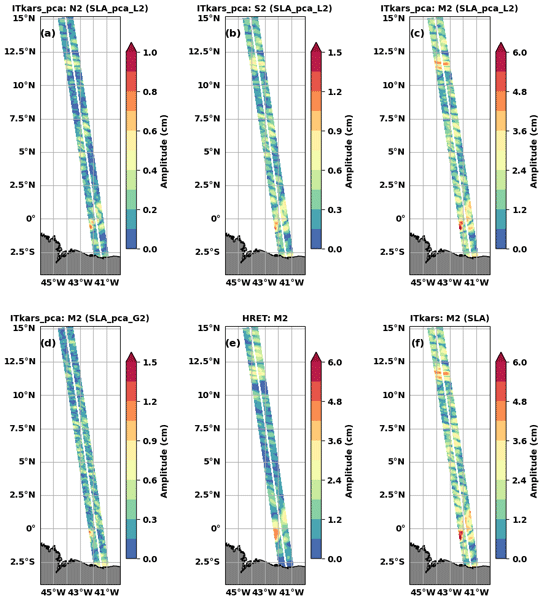
Michel Tchilibou, Loren Carrere, Florent Lyard, Clément Ubelmann, Gérald Dibarboure, Edward D. Zaron, and Brian K. Arbic
Ocean Sci., 21, 325–342, https://doi.org/10.5194/os-21-325-2025, https://doi.org/10.5194/os-21-325-2025, 2025
Short summary
Short summary
Sea level observations along the swaths of the new SWOT (Surface Water and Ocean Topography) mission were used to characterize internal tides at three semidiurnal frequencies off the Amazon shelf in the tropical Atlantic during the SWOT calibration/validation period. The atlases were derived using harmonic analysis and principal component analysis. The SWOT-derived internal tide atlas outperforms the reference atlas previously used to correct SWOT observations.
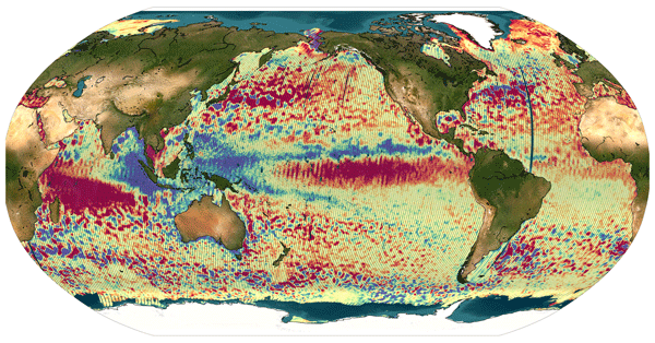
Gerald Dibarboure, Cécile Anadon, Frédéric Briol, Emeline Cadier, Robin Chevrier, Antoine Delepoulle, Yannice Faugère, Alice Laloue, Rosemary Morrow, Nicolas Picot, Pierre Prandi, Marie-Isabelle Pujol, Matthias Raynal, Anaelle Tréboutte, and Clément Ubelmann
Ocean Sci., 21, 283–323, https://doi.org/10.5194/os-21-283-2025, https://doi.org/10.5194/os-21-283-2025, 2025
Short summary
Short summary
The Surface Water and Ocean Topography (SWOT) mission delivers unprecedented swath-altimetry products. In this paper, we describe how we extended the Level-3 algorithms to handle SWOT’s unique swath-altimeter data. We also illustrate and discuss the benefits, relevance, and limitations of Level-3 swath-altimeter products for various research domains.
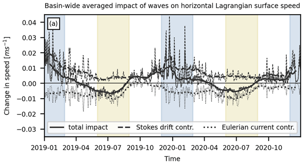
Siren Rühs, Ton van den Bremer, Emanuela Clementi, Michael C. Denes, Aimie Moulin, and Erik van Sebille
Ocean Sci., 21, 217–240, https://doi.org/10.5194/os-21-217-2025, https://doi.org/10.5194/os-21-217-2025, 2025
Short summary
Short summary
Simulating the transport of floating particles on the ocean surface is crucial for solving many societal issues. Here, we investigate how the representation of wind-generated surface waves impacts particle transport simulations. We find that different wave-driven processes can alter transport patterns and that commonly adopted approximations are not always adequate. This suggests that ideally coupled ocean–wave models should be used for surface particle transport simulations.
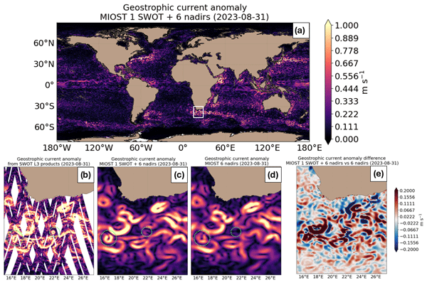
Maxime Ballarotta, Clément Ubelmann, Valentin Bellemin-Laponnaz, Florian Le Guillou, Guillaume Meda, Cécile Anadon, Alice Laloue, Antoine Delepoulle, Yannice Faugère, Marie-Isabelle Pujol, Ronan Fablet, and Gérald Dibarboure
Ocean Sci., 21, 63–80, https://doi.org/10.5194/os-21-63-2025, https://doi.org/10.5194/os-21-63-2025, 2025
Short summary
Short summary
The Surface Water and Ocean Topography (SWOT) mission provides unprecedented swath altimetry data. This study examines SWOT's impact on mapping systems, showing a moderate effect with the current nadir altimetry constellation and a stronger impact with a reduced one. Integrating SWOT with dynamic mapping techniques improves the resolution of satellite-derived products, offering promising solutions for studying and monitoring sea-level variability at finer scales.
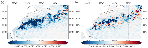
Robert R. King, Matthew J. Martin, Lucile Gaultier, Jennifer Waters, Clément Ubelmann, and Craig Donlon
Ocean Sci., 20, 1657–1676, https://doi.org/10.5194/os-20-1657-2024, https://doi.org/10.5194/os-20-1657-2024, 2024
Short summary
Short summary
We use simulations of our ocean forecasting system to compare the impact of additional altimeter observations from two proposed future satellite constellations. We found that, in our system, an altimeter constellation of 12 nadir altimeters produces improved predictions of sea surface height, surface currents, temperature, and salinity compared to a constellation of 2 wide-swath altimeters.
Yicun Zhen, Valentin Resseguier, and Bertrand Chapron
EGUsphere, https://doi.org/10.13140/RG.2.2.36204.37768, https://doi.org/10.13140/RG.2.2.36204.37768, 2024
Preprint archived
Short summary
Short summary
In a previous paper we made the conclusion that two different stochastic perturbation schemes can be derived under the same framework. The key is to associate each state variable a differential form. The perturbation of the state variables are thus consequences of the differential forms perturbed by a random map. A natural followup question is how to find the realizations of those random perturbations of identity map. An optimisation problem is proposed and further used for a nudging algorithm.
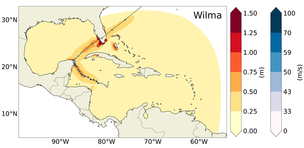
Alisée A. Chaigneau, Melisa Menéndez, Marta Ramírez-Pérez, and Alexandra Toimil
Nat. Hazards Earth Syst. Sci., 24, 4109–4131, https://doi.org/10.5194/nhess-24-4109-2024, https://doi.org/10.5194/nhess-24-4109-2024, 2024
Short summary
Short summary
Tropical cyclones drive extreme sea levels, causing large storm surges due to low atmospheric pressure and strong winds. This study explores factors affecting the numerical modelling of storm surges induced by hurricanes in the tropical Atlantic. Two ocean models are compared and used for sensitivity experiments. ERA5 atmospheric reanalysis forcing generally improves surge estimates compared to parametric wind models. Including ocean circulations reduces errors in surge estimates in some areas.
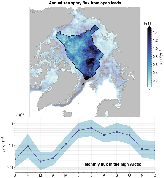
Rémy Lapere, Louis Marelle, Pierre Rampal, Laurent Brodeau, Christian Melsheimer, Gunnar Spreen, and Jennie L. Thomas
Atmos. Chem. Phys., 24, 12107–12132, https://doi.org/10.5194/acp-24-12107-2024, https://doi.org/10.5194/acp-24-12107-2024, 2024
Short summary
Short summary
Elongated open-water areas in sea ice, called leads, can release marine aerosols into the atmosphere. In the Arctic, this source of atmospheric particles could play an important role for climate. However, the amount, seasonality and spatial distribution of such emissions are all mostly unknown. Here, we propose a first parameterization for sea spray aerosols emitted through leads in sea ice and quantify their impact on aerosol populations in the high Arctic.
Simon Driscoll, Alberto Carrassi, Julien Brajard, Laurent Bertino, Einar Ólason, Marc Bocquet, and Amos Lawless
EGUsphere, https://doi.org/10.5194/egusphere-2024-2476, https://doi.org/10.5194/egusphere-2024-2476, 2024
Preprint archived
Short summary
Short summary
The formation and evolution of sea ice melt ponds (ponds of melted water) are complex, insufficiently understood and represented in models with considerable uncertainty. These uncertain representations are not traditionally included in climate models potentially causing the known underestimation of sea ice loss in climate models. Our work creates the first observationally based machine learning model of melt ponds that is also a ready and viable candidate to be included in climate models.
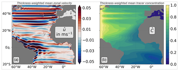
Eike E. Köhn, Richard J. Greatbatch, Peter Brandt, and Martin Claus
Ocean Sci., 20, 1281–1290, https://doi.org/10.5194/os-20-1281-2024, https://doi.org/10.5194/os-20-1281-2024, 2024
Short summary
Short summary
The latitudinally alternating zonal jets are a ubiquitous feature of the ocean. We use a simple model to illustrate the potential role of these jets in the formation, maintenance, and multidecadal variability in the oxygen minimum zones, using the eastern tropical North Atlantic oxygen minimum zone as an example.
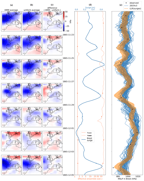
Paul Platzer, Pierre Ailliot, Bertrand Chapron, and Pierre Tandeo
Clim. Past, 20, 2267–2286, https://doi.org/10.5194/cp-20-2267-2024, https://doi.org/10.5194/cp-20-2267-2024, 2024
Short summary
Short summary
Old observations are necessary to understand the atmosphere. When direct observations are not available, one can use indirect observations, such as tide gauges, which measure the sea level in port cities. The sea level rises when local air pressure decreases and when wind pushes water towards the coast. Several centuries-long tide gauge records are available. We show that these can be complementary to direct pressure observations for studying storms and anticyclones in the 19th century.
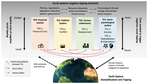
Viktoria Spaiser, Sirkku Juhola, Sara M. Constantino, Weisi Guo, Tabitha Watson, Jana Sillmann, Alessandro Craparo, Ashleigh Basel, John T. Bruun, Krishna Krishnamurthy, Jürgen Scheffran, Patricia Pinho, Uche T. Okpara, Jonathan F. Donges, Avit Bhowmik, Taha Yasseri, Ricardo Safra de Campos, Graeme S. Cumming, Hugues Chenet, Florian Krampe, Jesse F. Abrams, James G. Dyke, Stefanie Rynders, Yevgeny Aksenov, and Bryan M. Spears
Earth Syst. Dynam., 15, 1179–1206, https://doi.org/10.5194/esd-15-1179-2024, https://doi.org/10.5194/esd-15-1179-2024, 2024
Short summary
Short summary
In this paper, we identify potential negative social tipping points linked to Earth system destabilization and draw on related research to understand the drivers and likelihood of these negative social tipping dynamics, their potential effects on human societies and the Earth system, and the potential for cascading interactions and contribution to systemic risks.
Anna Leerink, Mark Bos, Daan Reijnders, and Erik van Sebille
Geosci. Commun., 7, 201–214, https://doi.org/10.5194/gc-7-201-2024, https://doi.org/10.5194/gc-7-201-2024, 2024
Short summary
Short summary
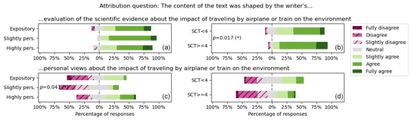
Climate scientists who communicate to a broad audience may be reluctant to write in a more personal style, as they assume that it hurts their credibility. To test this assumption, we asked 100 Dutch people to rate the credibility of a climate scientist. We varied how the author of the article addressed the reader and found that the degree of personalization did not have a measurable impact on the credibility of the author. Thus, we conclude that personalization may not hurt credibility.
Laurent Brodeau, Pierre Rampal, Einar Ólason, and Véronique Dansereau
Geosci. Model Dev., 17, 6051–6082, https://doi.org/10.5194/gmd-17-6051-2024, https://doi.org/10.5194/gmd-17-6051-2024, 2024
Short summary
Short summary
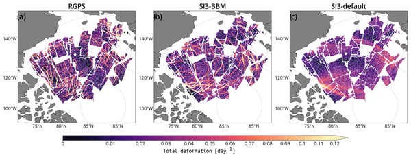
A new brittle sea ice rheology, BBM, has been implemented into the sea ice component of NEMO. We describe how a new spatial discretization framework was introduced to achieve this. A set of idealized and realistic ocean and sea ice simulations of the Arctic have been performed using BBM and the standard viscous–plastic rheology of NEMO. When compared to satellite data, our simulations show that our implementation of BBM leads to a fairly good representation of sea ice deformations.
Andreas Stokholm, Jørgen Buus-Hinkler, Tore Wulf, Anton Korosov, Roberto Saldo, Leif Toudal Pedersen, David Arthurs, Ionut Dragan, Iacopo Modica, Juan Pedro, Annekatrien Debien, Xinwei Chen, Muhammed Patel, Fernando Jose Pena Cantu, Javier Noa Turnes, Jinman Park, Linlin Xu, Katharine Andrea Scott, David Anthony Clausi, Yuan Fang, Mingzhe Jiang, Saeid Taleghanidoozdoozan, Neil Curtis Brubacher, Armina Soleymani, Zacharie Gousseau, Michał Smaczny, Patryk Kowalski, Jacek Komorowski, David Rijlaarsdam, Jan Nicolaas van Rijn, Jens Jakobsen, Martin Samuel James Rogers, Nick Hughes, Tom Zagon, Rune Solberg, Nicolas Longépé, and Matilde Brandt Kreiner
The Cryosphere, 18, 3471–3494, https://doi.org/10.5194/tc-18-3471-2024, https://doi.org/10.5194/tc-18-3471-2024, 2024
Short summary
Short summary
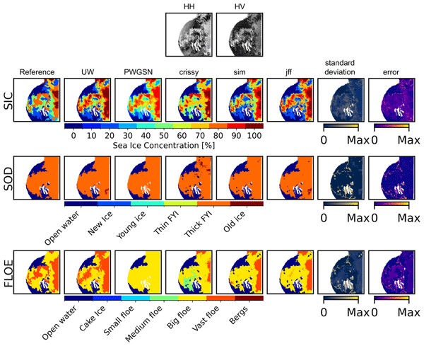
The AutoICE challenge encouraged the development of deep learning models to map multiple aspects of sea ice – the amount of sea ice in an area and the age and ice floe size – using multiple sources of satellite and weather data across the Canadian and Greenlandic Arctic. Professionally drawn operational sea ice charts were used as a reference. A total of 179 students and sea ice and AI specialists participated and produced maps in broad agreement with the sea ice charts.
Arne Bendinger, Sophie Cravatte, Lionel Gourdeau, Luc Rainville, Clément Vic, Guillaume Sérazin, Fabien Durand, Frédéric Marin, and Jean-Luc Fuda
Ocean Sci., 20, 945–964, https://doi.org/10.5194/os-20-945-2024, https://doi.org/10.5194/os-20-945-2024, 2024
Short summary
Short summary
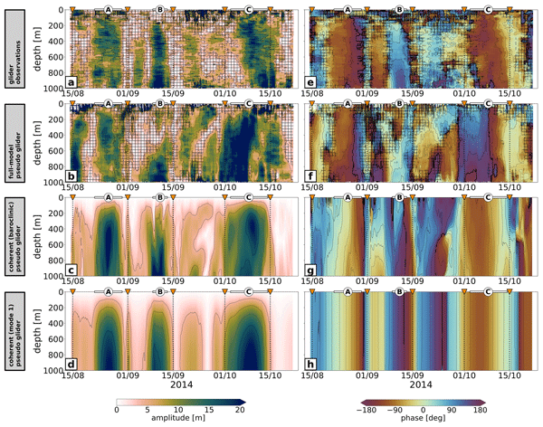
A unique dataset of glider observations reveals tidal beams south of New Caledonia – an internal-tide-generation hot spot in the southwestern tropical Pacific. Observations are in good agreement with numerical modeling output, highlighting the glider's capability to infer internal tides while assessing the model's realism of internal-tide dynamics. Discrepancies are in large part linked to eddy–internal-tide interactions. A methodology is proposed to deduce the internal-tide surface signature.
Alexander Kmoch, Benoit Bovy, Justus Magin, Ryan Abernathey, Alejandro Coca-Castro, Peter Strobl, Anne Fouilloux, Daniel Loos, Evelyn Uuemaa, Wai Tik Chan, Jean-Marc Delouis, and Tina Odaka
Int. Arch. Photogramm. Remote Sens. Spatial Inf. Sci., XLVIII-4-W12-2024, 75–80, https://doi.org/10.5194/isprs-archives-XLVIII-4-W12-2024-75-2024, https://doi.org/10.5194/isprs-archives-XLVIII-4-W12-2024-75-2024, 2024
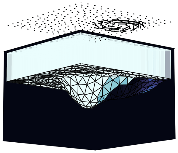
Yumeng Chen, Polly Smith, Alberto Carrassi, Ivo Pasmans, Laurent Bertino, Marc Bocquet, Tobias Sebastian Finn, Pierre Rampal, and Véronique Dansereau
The Cryosphere, 18, 2381–2406, https://doi.org/10.5194/tc-18-2381-2024, https://doi.org/10.5194/tc-18-2381-2024, 2024
Short summary
Short summary
We explore multivariate state and parameter estimation using a data assimilation approach through idealised simulations in a dynamics-only sea-ice model based on novel rheology. We identify various potential issues that can arise in complex operational sea-ice models when model parameters are estimated. Even though further investigation will be needed for such complex sea-ice models, we show possibilities of improving the observed and the unobserved model state forecast and parameter accuracy.

Alvise Benetazzo, Trygve Halsne, Øyvind Breivik, Kjersti Opstad Strand, Adrian H. Callaghan, Francesco Barbariol, Silvio Davison, Filippo Bergamasco, Cristobal Molina, and Mauro Bastianini
Ocean Sci., 20, 639–660, https://doi.org/10.5194/os-20-639-2024, https://doi.org/10.5194/os-20-639-2024, 2024
Short summary
Short summary
We investigated the behaviour of air bubble plumes in the upper ocean in various stormy conditions. We conducted a field experiment in the North Adriatic Sea using high-resolution sonar. We found that bubble penetration depths respond rapidly to wind and wave forcings and can be triggered by the cooling of the water masses. We also found a strong connection between bubble depths and theoretical CO2 gas transfer. Our findings have implications for air–sea interaction studies.
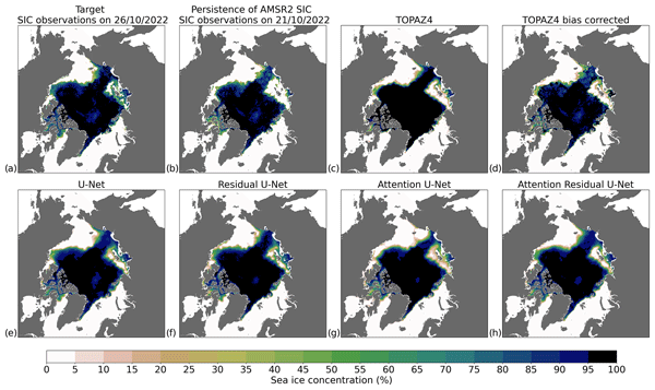
Cyril Palerme, Thomas Lavergne, Jozef Rusin, Arne Melsom, Julien Brajard, Are Frode Kvanum, Atle Macdonald Sørensen, Laurent Bertino, and Malte Müller
The Cryosphere, 18, 2161–2176, https://doi.org/10.5194/tc-18-2161-2024, https://doi.org/10.5194/tc-18-2161-2024, 2024
Short summary
Short summary
Sea ice forecasts are operationally produced using physically based models, but these forecasts are often not accurate enough for maritime operations. In this study, we developed a statistical correction technique using machine learning in order to improve the skill of short-term (up to 10 d) sea ice concentration forecasts produced by the TOPAZ4 model. This technique allows for the reduction of errors from the TOPAZ4 sea ice concentration forecasts by 41 % on average.
Frances Wijnen, Madelijn Strick, Mark Bos, and Erik van Sebille
Geosci. Commun., 7, 91–100, https://doi.org/10.5194/gc-7-91-2024, https://doi.org/10.5194/gc-7-91-2024, 2024
Short summary
Short summary
Climate scientists are urged to communicate climate science; there is very little evidence about what types of communication work well for which audiences. We have performed a systematic literature review to analyze what is known about the efficacy of climate communication by scientists. While we have found more than 60 articles in the last 10 years about climate communication activities by scientists, only 7 of these included some form of evaluation of the impact of the activity.
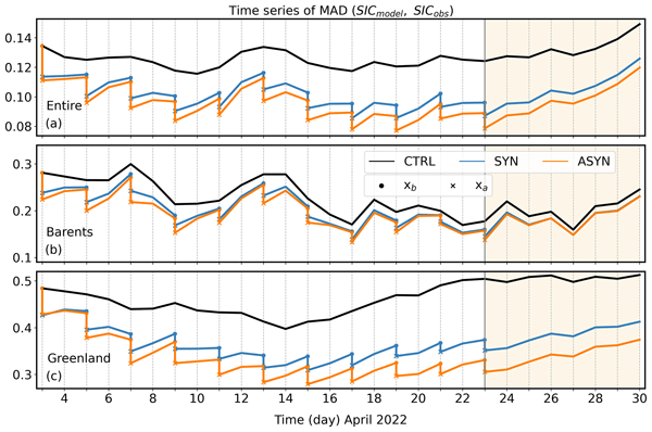
Marina Durán Moro, Ann Kristin Sperrevik, Thomas Lavergne, Laurent Bertino, Yvonne Gusdal, Silje Christine Iversen, and Jozef Rusin
The Cryosphere, 18, 1597–1619, https://doi.org/10.5194/tc-18-1597-2024, https://doi.org/10.5194/tc-18-1597-2024, 2024
Short summary
Short summary
Individual satellite passes instead of daily means of sea ice concentration are used to correct the sea ice model forecast in the Barents Sea. The use of passes provides a significantly larger improvement of the forecasts even after a 7 d period due to the more precise information on temporal and spatial variability contained in the passes. One major advantage of the use of satellite passes is that there is no need to wait for the daily mean availability in order to update the forecast.
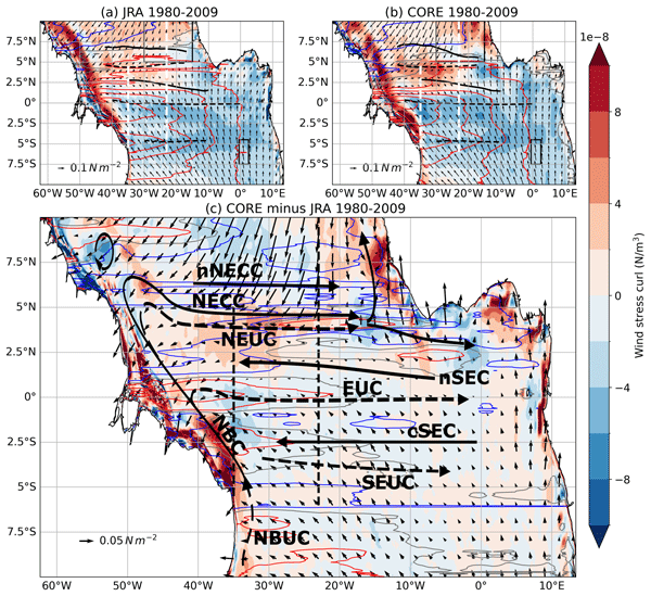
Kristin Burmeister, Franziska U. Schwarzkopf, Willi Rath, Arne Biastoch, Peter Brandt, Joke F. Lübbecke, and Mark Inall
Ocean Sci., 20, 307–339, https://doi.org/10.5194/os-20-307-2024, https://doi.org/10.5194/os-20-307-2024, 2024
Short summary
Short summary
We apply two different forcing products to a high-resolution ocean model to investigate their impact on the simulated upper-current field in the tropical Atlantic. Where possible, we compare the simulated results to long-term observations. We find large discrepancies between the two simulations regarding the wind and current fields. We propose that long-term observations, once they have reached a critical length, need to be used to test the quality of wind-driven simulations.
Marta Umbert, Eva De Andrés, Maria Sánchez, Carolina Gabarró, Nina Hoareau, Veronica González-Gambau, Aina García-Espriu, Estrella Olmedo, Roshin P. Raj, Jiping Xie, and Rafael Catany
Ocean Sci., 20, 279–291, https://doi.org/10.5194/os-20-279-2024, https://doi.org/10.5194/os-20-279-2024, 2024
Short summary
Short summary
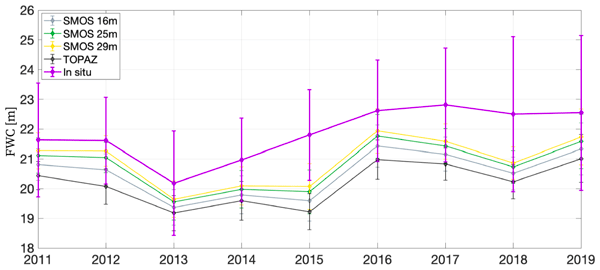
Satellite retrievals of sea surface salinity (SSS) offer insights into freshwater changes in the Arctic Ocean. This study evaluates freshwater content in the Beaufort Gyre using SMOS and reanalysis data, revealing underestimation with reanalysis alone. Incorporating satellite SSS measurements improves freshwater content estimation, especially near ice-melting areas. Adding remotely sensed salinity aids in monitoring Arctic freshwater content and in understanding its impact on global climate.
Nico Wunderling, Anna S. von der Heydt, Yevgeny Aksenov, Stephen Barker, Robbin Bastiaansen, Victor Brovkin, Maura Brunetti, Victor Couplet, Thomas Kleinen, Caroline H. Lear, Johannes Lohmann, Rosa Maria Roman-Cuesta, Sacha Sinet, Didier Swingedouw, Ricarda Winkelmann, Pallavi Anand, Jonathan Barichivich, Sebastian Bathiany, Mara Baudena, John T. Bruun, Cristiano M. Chiessi, Helen K. Coxall, David Docquier, Jonathan F. Donges, Swinda K. J. Falkena, Ann Kristin Klose, David Obura, Juan Rocha, Stefanie Rynders, Norman Julius Steinert, and Matteo Willeit
Earth Syst. Dynam., 15, 41–74, https://doi.org/10.5194/esd-15-41-2024, https://doi.org/10.5194/esd-15-41-2024, 2024
Short summary
Short summary
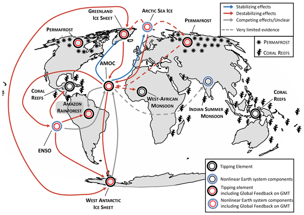
This paper maps out the state-of-the-art literature on interactions between tipping elements relevant for current global warming pathways. We find indications that many of the interactions between tipping elements are destabilizing. This means that tipping cascades cannot be ruled out on centennial to millennial timescales at global warming levels between 1.5 and 2.0 °C or on shorter timescales if global warming surpasses 2.0 °C.
Philippe F. V. W. Frankemölle, Peter D. Nooteboom, Joe Scutt Phillips, Lauriane Escalle, Simon Nicol, and Erik van Sebille
Ocean Sci., 20, 31–41, https://doi.org/10.5194/os-20-31-2024, https://doi.org/10.5194/os-20-31-2024, 2024
Short summary
Short summary
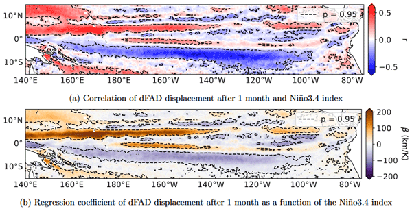
Tuna fisheries in the Pacific often use drifting fish aggregating devices (dFADs) to attract fish that are advected by subsurface flow through underwater appendages. Using a particle advection model, we find that virtual particles advected by surface flow are displaced farther than virtual dFADs. We find a relation between El Niño–Southern Oscillation and circular motion in some areas, influencing dFAD densities. This information helps us to understand processes that drive dFAD distribution.
Florian Le Guillou, Lucile Gaultier, Maxime Ballarotta, Sammy Metref, Clément Ubelmann, Emmanuel Cosme, and Marie-Helène Rio
Ocean Sci., 19, 1517–1527, https://doi.org/10.5194/os-19-1517-2023, https://doi.org/10.5194/os-19-1517-2023, 2023
Short summary
Short summary
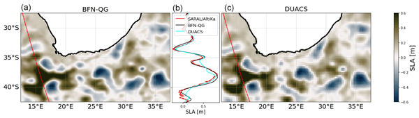
Altimetry provides sea surface height (SSH) data along one-dimensional tracks. For many applications, the tracks are interpolated in space and time to provide gridded SSH maps. The operational SSH gridded products filter out the small-scale signals measured on the tracks. This paper evaluates the performances of a recently implemented dynamical method to retrieve the small-scale signals from real SSH data. We show a net improvement in the quality of SSH maps when compared to independent data.
Christoph Heinze, Thorsten Blenckner, Peter Brown, Friederike Fröb, Anne Morée, Adrian L. New, Cara Nissen, Stefanie Rynders, Isabel Seguro, Yevgeny Aksenov, Yuri Artioli, Timothée Bourgeois, Friedrich Burger, Jonathan Buzan, B. B. Cael, Veli Çağlar Yumruktepe, Melissa Chierici, Christopher Danek, Ulf Dieckmann, Agneta Fransson, Thomas Frölicher, Giovanni Galli, Marion Gehlen, Aridane G. González, Melchor Gonzalez-Davila, Nicolas Gruber, Örjan Gustafsson, Judith Hauck, Mikko Heino, Stephanie Henson, Jenny Hieronymus, I. Emma Huertas, Fatma Jebri, Aurich Jeltsch-Thömmes, Fortunat Joos, Jaideep Joshi, Stephen Kelly, Nandini Menon, Precious Mongwe, Laurent Oziel, Sólveig Ólafsdottir, Julien Palmieri, Fiz F. Pérez, Rajamohanan Pillai Ranith, Juliano Ramanantsoa, Tilla Roy, Dagmara Rusiecka, J. Magdalena Santana Casiano, Yeray Santana-Falcón, Jörg Schwinger, Roland Séférian, Miriam Seifert, Anna Shchiptsova, Bablu Sinha, Christopher Somes, Reiner Steinfeldt, Dandan Tao, Jerry Tjiputra, Adam Ulfsbo, Christoph Völker, Tsuyoshi Wakamatsu, and Ying Ye
Biogeosciences Discuss., https://doi.org/10.5194/bg-2023-182, https://doi.org/10.5194/bg-2023-182, 2023
Revised manuscript not accepted
Short summary
Short summary
For assessing the consequences of human-induced climate change for the marine realm, it is necessary to not only look at gradual changes but also at abrupt changes of environmental conditions. We summarise abrupt changes in ocean warming, acidification, and oxygen concentration as the key environmental factors for ecosystems. Taking these abrupt changes into account requires greenhouse gas emissions to be reduced to a larger extent than previously thought to limit respective damage.
Anton Korosov, Pierre Rampal, Yue Ying, Einar Ólason, and Timothy Williams
The Cryosphere, 17, 4223–4240, https://doi.org/10.5194/tc-17-4223-2023, https://doi.org/10.5194/tc-17-4223-2023, 2023
Short summary
Short summary
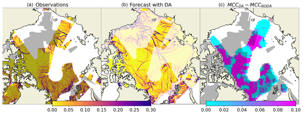
It is possible to compute sea ice motion from satellite observations and detect areas where ice converges (moves together), forms ice ridges or diverges (moves apart) and opens leads. However, it is difficult to predict the exact motion of sea ice and position of ice ridges or leads using numerical models. We propose a new method to initialise a numerical model from satellite observations to improve the accuracy of the forecasted position of leads and ridges for safer navigation.
Stefania A. Ciliberti, Enrique Alvarez Fanjul, Jay Pearlman, Kirsten Wilmer-Becker, Pierre Bahurel, Fabrice Ardhuin, Alain Arnaud, Mike Bell, Segolene Berthou, Laurent Bertino, Arthur Capet, Eric Chassignet, Stefano Ciavatta, Mauro Cirano, Emanuela Clementi, Gianpiero Cossarini, Gianpaolo Coro, Stuart Corney, Fraser Davidson, Marie Drevillon, Yann Drillet, Renaud Dussurget, Ghada El Serafy, Katja Fennel, Marcos Garcia Sotillo, Patrick Heimbach, Fabrice Hernandez, Patrick Hogan, Ibrahim Hoteit, Sudheer Joseph, Simon Josey, Pierre-Yves Le Traon, Simone Libralato, Marco Mancini, Pascal Matte, Angelique Melet, Yasumasa Miyazawa, Andrew M. Moore, Antonio Novellino, Andrew Porter, Heather Regan, Laia Romero, Andreas Schiller, John Siddorn, Joanna Staneva, Cecile Thomas-Courcoux, Marina Tonani, Jose Maria Garcia-Valdecasas, Jennifer Veitch, Karina von Schuckmann, Liying Wan, John Wilkin, and Romane Zufic
State Planet, 1-osr7, 2, https://doi.org/10.5194/sp-1-osr7-2-2023, https://doi.org/10.5194/sp-1-osr7-2-2023, 2023
Tor Nordam, Ruben Kristiansen, Raymond Nepstad, Erik van Sebille, and Andy M. Booth
Geosci. Model Dev., 16, 5339–5363, https://doi.org/10.5194/gmd-16-5339-2023, https://doi.org/10.5194/gmd-16-5339-2023, 2023
Short summary
Short summary
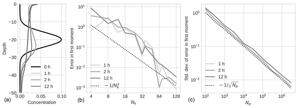
We describe and compare two common methods, Eulerian and Lagrangian models, used to simulate the vertical transport of material in the ocean. They both solve the same transport problems but use different approaches for representing the underlying equations on the computer. The main focus of our study is on the numerical accuracy of the two approaches. Our results should be useful for other researchers creating or using these types of transport models.
Arne Bendinger, Sophie Cravatte, Lionel Gourdeau, Laurent Brodeau, Aurélie Albert, Michel Tchilibou, Florent Lyard, and Clément Vic
Ocean Sci., 19, 1315–1338, https://doi.org/10.5194/os-19-1315-2023, https://doi.org/10.5194/os-19-1315-2023, 2023
Short summary
Short summary
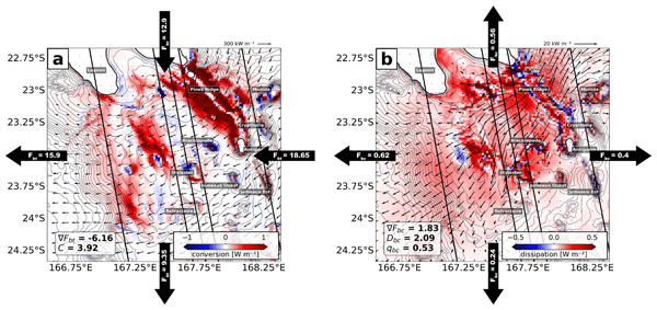
New Caledonia is a hot spot of internal-tide generation due to complex bathymetry. Regional modeling quantifies the coherent internal tide and shows that most energy is converted in shallow waters and on very steep slopes. The region is a challenge for observability of balanced dynamics due to strong internal-tide sea surface height (SSH) signatures at similar wavelengths. Correcting the SSH for the coherent internal tide may increase the observability of balanced motion to < 100 km.
Yanan Wang, Byongjun Hwang, Adam William Bateson, Yevgeny Aksenov, and Christopher Horvat
The Cryosphere, 17, 3575–3591, https://doi.org/10.5194/tc-17-3575-2023, https://doi.org/10.5194/tc-17-3575-2023, 2023
Short summary
Short summary
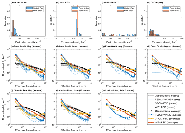
Sea ice is composed of small, discrete pieces of ice called floes, whose size distribution plays a critical role in the interactions between the sea ice, ocean and atmosphere. This study provides an assessment of sea ice models using new high-resolution floe size distribution observations, revealing considerable differences between them. These findings point not only to the limitations in models but also to the need for more high-resolution observations to validate and calibrate models.
Swantje Bastin, Martin Claus, Richard J. Greatbatch, and Peter Brandt
Ocean Sci., 19, 923–939, https://doi.org/10.5194/os-19-923-2023, https://doi.org/10.5194/os-19-923-2023, 2023
Short summary
Short summary
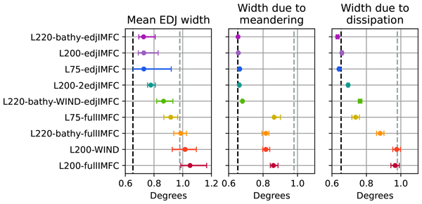
Equatorial deep jets are ocean currents that flow along the Equator in the deep oceans. They are relevant for oxygen transport and tropical surface climate, but their dynamics are not yet entirely understood. We investigate different factors leading to the jets being broader than theory predicts. Mainly using an ocean model, but corroborating the results with shipboard observations, we show that loss of momentum is the main factor for the broadening but that meandering also contributes.
Peter Brandt, Gaël Alory, Founi Mesmin Awo, Marcus Dengler, Sandrine Djakouré, Rodrigue Anicet Imbol Koungue, Julien Jouanno, Mareike Körner, Marisa Roch, and Mathieu Rouault
Ocean Sci., 19, 581–601, https://doi.org/10.5194/os-19-581-2023, https://doi.org/10.5194/os-19-581-2023, 2023
Short summary
Short summary
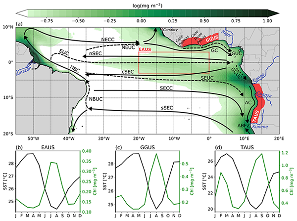
Tropical upwelling systems are among the most productive ecosystems globally. The tropical Atlantic upwelling undergoes a strong seasonal cycle that is forced by the wind. Local wind-driven upwelling and remote effects, particularly via the propagation of equatorial and coastal trapped waves, lead to an upward and downward movement of the nitracline. Turbulent mixing results in upward supply of nutrients. Here, we review the different physical processes responsible for biological productivity.
Heather Regan, Pierre Rampal, Einar Ólason, Guillaume Boutin, and Anton Korosov
The Cryosphere, 17, 1873–1893, https://doi.org/10.5194/tc-17-1873-2023, https://doi.org/10.5194/tc-17-1873-2023, 2023
Short summary
Short summary
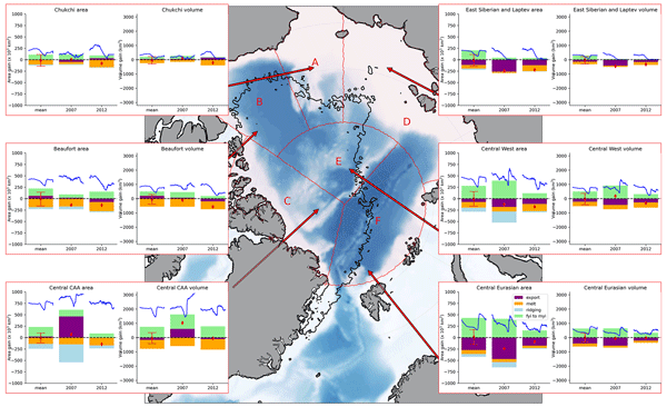
Multiyear ice (MYI), sea ice that survives the summer, is more resistant to changes than younger ice in the Arctic, so it is a good indicator of sea ice resilience. We use a model with a new way of tracking MYI to assess the contribution of different processes affecting MYI. We find two important years for MYI decline: 2007, when dynamics are important, and 2012, when melt is important. These affect MYI volume and area in different ways, which is important for the interpretation of observations.
Sukun Cheng, Yumeng Chen, Ali Aydoğdu, Laurent Bertino, Alberto Carrassi, Pierre Rampal, and Christopher K. R. T. Jones
The Cryosphere, 17, 1735–1754, https://doi.org/10.5194/tc-17-1735-2023, https://doi.org/10.5194/tc-17-1735-2023, 2023
Short summary
Short summary
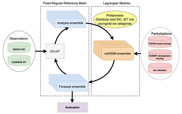
This work studies a novel application of combining a Lagrangian sea ice model, neXtSIM, and data assimilation. It uses a deterministic ensemble Kalman filter to incorporate satellite-observed ice concentration and thickness in simulations. The neXtSIM Lagrangian nature is handled using a remapping strategy on a common homogeneous mesh. The ensemble is formed by perturbing air–ocean boundary conditions and ice cohesion. Thanks to data assimilation, winter Arctic sea ice forecasting is enhanced.
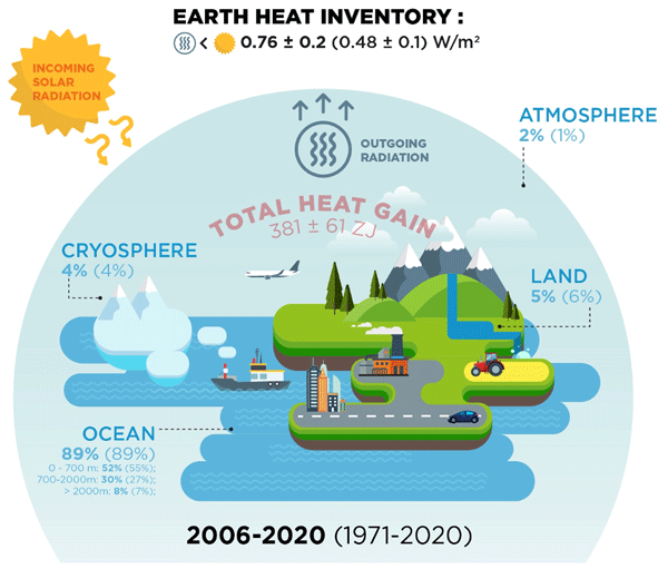
Karina von Schuckmann, Audrey Minière, Flora Gues, Francisco José Cuesta-Valero, Gottfried Kirchengast, Susheel Adusumilli, Fiammetta Straneo, Michaël Ablain, Richard P. Allan, Paul M. Barker, Hugo Beltrami, Alejandro Blazquez, Tim Boyer, Lijing Cheng, John Church, Damien Desbruyeres, Han Dolman, Catia M. Domingues, Almudena García-García, Donata Giglio, John E. Gilson, Maximilian Gorfer, Leopold Haimberger, Maria Z. Hakuba, Stefan Hendricks, Shigeki Hosoda, Gregory C. Johnson, Rachel Killick, Brian King, Nicolas Kolodziejczyk, Anton Korosov, Gerhard Krinner, Mikael Kuusela, Felix W. Landerer, Moritz Langer, Thomas Lavergne, Isobel Lawrence, Yuehua Li, John Lyman, Florence Marti, Ben Marzeion, Michael Mayer, Andrew H. MacDougall, Trevor McDougall, Didier Paolo Monselesan, Jan Nitzbon, Inès Otosaka, Jian Peng, Sarah Purkey, Dean Roemmich, Kanako Sato, Katsunari Sato, Abhishek Savita, Axel Schweiger, Andrew Shepherd, Sonia I. Seneviratne, Leon Simons, Donald A. Slater, Thomas Slater, Andrea K. Steiner, Toshio Suga, Tanguy Szekely, Wim Thiery, Mary-Louise Timmermans, Inne Vanderkelen, Susan E. Wjiffels, Tonghua Wu, and Michael Zemp
Earth Syst. Sci. Data, 15, 1675–1709, https://doi.org/10.5194/essd-15-1675-2023, https://doi.org/10.5194/essd-15-1675-2023, 2023
Short summary
Short summary
Earth's climate is out of energy balance, and this study quantifies how much heat has consequently accumulated over the past decades (ocean: 89 %, land: 6 %, cryosphere: 4 %, atmosphere: 1 %). Since 1971, this accumulated heat reached record values at an increasing pace. The Earth heat inventory provides a comprehensive view on the status and expectation of global warming, and we call for an implementation of this global climate indicator into the Paris Agreement’s Global Stocktake.

Oscar Vergara, Rosemary Morrow, Marie-Isabelle Pujol, Gérald Dibarboure, and Clément Ubelmann
Ocean Sci., 19, 363–379, https://doi.org/10.5194/os-19-363-2023, https://doi.org/10.5194/os-19-363-2023, 2023
Short summary
Short summary
Recent advances allow us to observe the ocean from space with increasingly higher detail, challenging our knowledge of the ocean's surface height signature. We use a statistical approach to determine the spatial scale at which the sea surface height signal is no longer dominated by geostrophic turbulence but in turn becomes dominated by wave-type motions. This information helps us to better use the data provided by ocean-observing satellites and to gain knowledge on climate-driving processes.
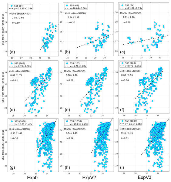
Jiping Xie, Roshin P. Raj, Laurent Bertino, Justino Martínez, Carolina Gabarró, and Rafael Catany
Ocean Sci., 19, 269–287, https://doi.org/10.5194/os-19-269-2023, https://doi.org/10.5194/os-19-269-2023, 2023
Short summary
Short summary
Sea ice melt, together with other freshwater sources, has effects on the Arctic environment. Sea surface salinity (SSS) plays a key role in representing water mixing. Recently the satellite SSS from SMOS was developed in the Arctic region. In this study, we first evaluate the impact of assimilating these satellite data in an Arctic reanalysis system. It shows that SSS errors are reduced by 10–50 % depending on areas, encouraging its use in a long-time reanalysis to monitor the Arctic water cycle.
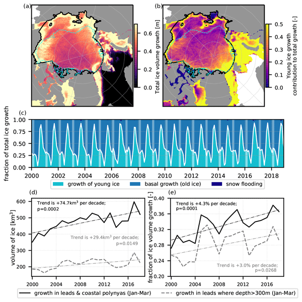
Guillaume Boutin, Einar Ólason, Pierre Rampal, Heather Regan, Camille Lique, Claude Talandier, Laurent Brodeau, and Robert Ricker
The Cryosphere, 17, 617–638, https://doi.org/10.5194/tc-17-617-2023, https://doi.org/10.5194/tc-17-617-2023, 2023
Short summary
Short summary
Sea ice cover in the Arctic is full of cracks, which we call leads. We suspect that these leads play a role for atmosphere–ocean interactions in polar regions, but their importance remains challenging to estimate. We use a new ocean–sea ice model with an original way of representing sea ice dynamics to estimate their impact on winter sea ice production. This model successfully represents sea ice evolution from 2000 to 2018, and we find that about 30 % of ice production takes place in leads.
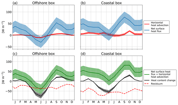
Mareike Körner, Peter Brandt, and Marcus Dengler
Ocean Sci., 19, 121–139, https://doi.org/10.5194/os-19-121-2023, https://doi.org/10.5194/os-19-121-2023, 2023
Short summary
Short summary
The coastal waters off Angola host a productive ecosystem. Surface waters at the coast are colder than further offshore. We find that surface heat fluxes warm the coastal region more strongly than the offshore region and cannot explain the differences. The influence of horizontal heat advection is minor on the surface temperature change. In contrast, ocean turbulence data suggest that cooling associated with vertical mixing is an important mechanism to explain the near-coastal cooling.
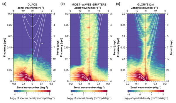
Maxime Ballarotta, Clément Ubelmann, Pierre Veillard, Pierre Prandi, Hélène Etienne, Sandrine Mulet, Yannice Faugère, Gérald Dibarboure, Rosemary Morrow, and Nicolas Picot
Earth Syst. Sci. Data, 15, 295–315, https://doi.org/10.5194/essd-15-295-2023, https://doi.org/10.5194/essd-15-295-2023, 2023
Short summary
Short summary
We present a new gridded sea surface height and current dataset produced by combining observations from nadir altimeters and drifting buoys. This product is based on a multiscale and multivariate mapping approach that offers the possibility to improve the physical content of gridded products by combining the data from various platforms and resolving a broader spectrum of ocean surface dynamic than in the current operational mapping system. A quality assessment of this new product is presented.
Matias Alday, Fabrice Ardhuin, Guillaume Dodet, and Mickael Accensi
Ocean Sci., 18, 1665–1689, https://doi.org/10.5194/os-18-1665-2022, https://doi.org/10.5194/os-18-1665-2022, 2022
Short summary
Short summary
Obtaining accurate results from wave models in coastal regions is typically more difficult. This is due to the complex interactions between waves and the local environment characteristics like complex shorelines, sea bottom topography, the presence of strong currents, and other processes that include wave growth and decay. In the present study we analyze which elements can be adjusted and/or included in order to reduce errors in the modeled output.
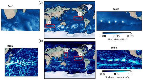
Hector S. Torres, Patrice Klein, Jinbo Wang, Alexander Wineteer, Bo Qiu, Andrew F. Thompson, Lionel Renault, Ernesto Rodriguez, Dimitris Menemenlis, Andrea Molod, Christopher N. Hill, Ehud Strobach, Hong Zhang, Mar Flexas, and Dragana Perkovic-Martin
Geosci. Model Dev., 15, 8041–8058, https://doi.org/10.5194/gmd-15-8041-2022, https://doi.org/10.5194/gmd-15-8041-2022, 2022
Short summary
Short summary
Wind work at the air-sea interface is the scalar product of winds and currents and is the transfer of kinetic energy between the ocean and the atmosphere. Using a new global coupled ocean-atmosphere simulation performed at kilometer resolution, we show that all scales of winds and currents impact the ocean dynamics at spatial and temporal scales. The consequential interplay of surface winds and currents in the numerical simulation motivates the need for a winds and currents satellite mission.
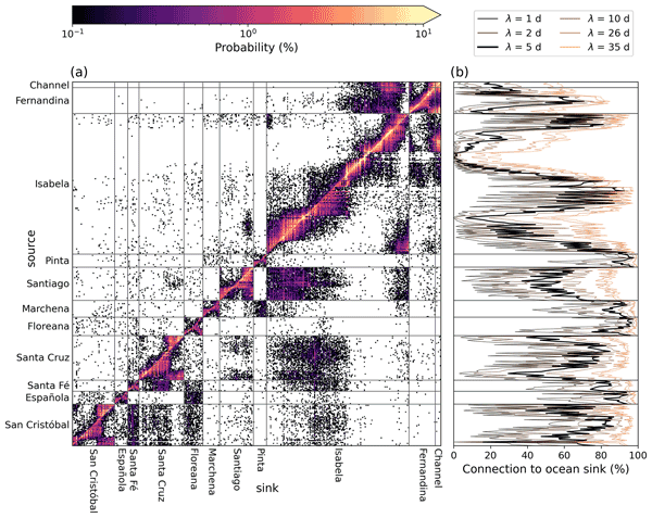
Stefanie L. Ypma, Quinten Bohte, Alexander Forryan, Alberto C. Naveira Garabato, Andy Donnelly, and Erik van Sebille
Ocean Sci., 18, 1477–1490, https://doi.org/10.5194/os-18-1477-2022, https://doi.org/10.5194/os-18-1477-2022, 2022
Short summary
Short summary
In this research we aim to improve cleanup efforts on the Galapagos Islands of marine plastic debris when resources are limited and the distribution of the plastic on shorelines is unknown. Using a network that describes the flow of macroplastic between the islands we have identified the most efficient cleanup locations, quantified the impact of targeting these locations and showed that shorelines where the plastic is unlikely to leave are likely efficient cleanup locations.
Vidar S. Lien, Angelika H. H. Renner, Mari S. Myksvoll, Johnny A. Johannessen, Jeremy Cook, Helene Spurkeland, and Ronald Toppe
State Planet Discuss., https://doi.org/10.5194/sp-2022-12, https://doi.org/10.5194/sp-2022-12, 2022
Preprint withdrawn
Short summary
Short summary
The One Ocean Expedition, a part of the United Nations Ocean Decade, is a sailing voyage where a traditional tall ship equipped with state-of-the-art ocean observation technology is circumnavigating the globe with a crew consisting of students, scientists, trainees and professionals. The focus for the expedition is awareness raising and education through showcasing ocean science using a traditional tall ship as a platform.
Marie-Isabelle Pujol, Stéphanie Dupuy, Oscar Vergara, Antonio Sánchez-Román, Yannice Faugère, Pierre Prandi, Mei-Ling Dabat, Quentin Dagneaux, Marine Lievin, Emeline Cadier, Gérald Dibarboure, and Nicolas Picot
Earth Syst. Sci. Data Discuss., https://doi.org/10.5194/essd-2022-292, https://doi.org/10.5194/essd-2022-292, 2022
Manuscript not accepted for further review
Short summary
Short summary
An altimeter sea level along-track level-3 product with a 5 Hz (~1.2 km) sampling is proposed. It takes advantage of recent advances in radar altimeter processing, and improvements made to different stages of the processing chain. Compared to the conventional 1 Hz (~7 km) product, it significantly improves the observability of the short wavelength signal in open ocean and near coast areas (> 5 km). It also contributes to improving high resolution numerical model outputs via data assimilation.
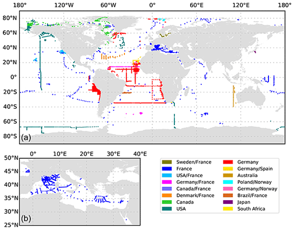
Rainer Kiko, Marc Picheral, David Antoine, Marcel Babin, Léo Berline, Tristan Biard, Emmanuel Boss, Peter Brandt, Francois Carlotti, Svenja Christiansen, Laurent Coppola, Leandro de la Cruz, Emilie Diamond-Riquier, Xavier Durrieu de Madron, Amanda Elineau, Gabriel Gorsky, Lionel Guidi, Helena Hauss, Jean-Olivier Irisson, Lee Karp-Boss, Johannes Karstensen, Dong-gyun Kim, Rachel M. Lekanoff, Fabien Lombard, Rubens M. Lopes, Claudie Marec, Andrew M. P. McDonnell, Daniela Niemeyer, Margaux Noyon, Stephanie H. O'Daly, Mark D. Ohman, Jessica L. Pretty, Andreas Rogge, Sarah Searson, Masashi Shibata, Yuji Tanaka, Toste Tanhua, Jan Taucher, Emilia Trudnowska, Jessica S. Turner, Anya Waite, and Lars Stemmann
Earth Syst. Sci. Data, 14, 4315–4337, https://doi.org/10.5194/essd-14-4315-2022, https://doi.org/10.5194/essd-14-4315-2022, 2022
Short summary
Short summary
The term
marine particlescomprises detrital aggregates; fecal pellets; bacterioplankton, phytoplankton and zooplankton; and even fish. Here, we present a global dataset that contains 8805 vertical particle size distribution profiles obtained with Underwater Vision Profiler 5 (UVP5) camera systems. These data are valuable to the scientific community, as they can be used to constrain important biogeochemical processes in the ocean, such as the flux of carbon to the deep sea.
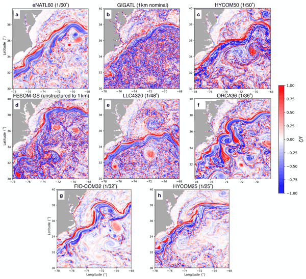
Takaya Uchida, Julien Le Sommer, Charles Stern, Ryan P. Abernathey, Chris Holdgraf, Aurélie Albert, Laurent Brodeau, Eric P. Chassignet, Xiaobiao Xu, Jonathan Gula, Guillaume Roullet, Nikolay Koldunov, Sergey Danilov, Qiang Wang, Dimitris Menemenlis, Clément Bricaud, Brian K. Arbic, Jay F. Shriver, Fangli Qiao, Bin Xiao, Arne Biastoch, René Schubert, Baylor Fox-Kemper, William K. Dewar, and Alan Wallcraft
Geosci. Model Dev., 15, 5829–5856, https://doi.org/10.5194/gmd-15-5829-2022, https://doi.org/10.5194/gmd-15-5829-2022, 2022
Short summary
Short summary
Ocean and climate scientists have used numerical simulations as a tool to examine the ocean and climate system since the 1970s. Since then, owing to the continuous increase in computational power and advances in numerical methods, we have been able to simulate increasing complex phenomena. However, the fidelity of the simulations in representing the phenomena remains a core issue in the ocean science community. Here we propose a cloud-based framework to inter-compare and assess such simulations.
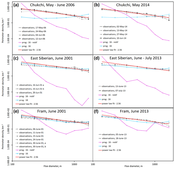
Adam William Bateson, Daniel L. Feltham, David Schröder, Yanan Wang, Byongjun Hwang, Jeff K. Ridley, and Yevgeny Aksenov
The Cryosphere, 16, 2565–2593, https://doi.org/10.5194/tc-16-2565-2022, https://doi.org/10.5194/tc-16-2565-2022, 2022
Short summary
Short summary
Numerical models are used to understand the mechanisms that drive the evolution of the Arctic sea ice cover. The sea ice cover is formed of pieces of ice called floes. Several recent studies have proposed variable floe size models to replace the standard model assumption of a fixed floe size. In this study we show the need to include floe fragmentation processes in these variable floe size models and demonstrate that model design can determine the impact of floe size on size ice evolution.
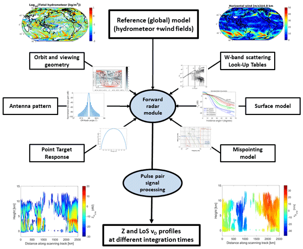
Alessandro Battaglia, Paolo Martire, Eric Caubet, Laurent Phalippou, Fabrizio Stesina, Pavlos Kollias, and Anthony Illingworth
Atmos. Meas. Tech., 15, 3011–3030, https://doi.org/10.5194/amt-15-3011-2022, https://doi.org/10.5194/amt-15-3011-2022, 2022
Short summary
Short summary
We present an instrument simulator for a new sensor, WIVERN (WInd VElocity Radar Nephoscope), a conically scanning radar payload with Doppler capabilities, recently down-selected as one of the four candidates for the European Space Agency Earth Explorer 11 program. The mission aims at measuring horizontal winds in cloudy areas. The simulator is instrumental in the definition and consolidation of the mission requirements and the evaluation of mission performances.
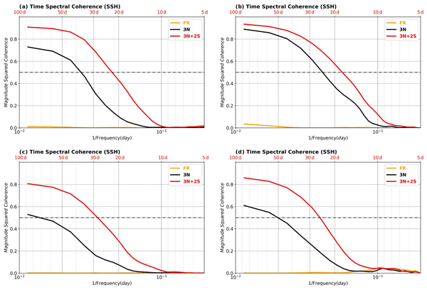
Mounir Benkiran, Pierre-Yves Le Traon, and Gérald Dibarboure
Ocean Sci., 18, 609–625, https://doi.org/10.5194/os-18-609-2022, https://doi.org/10.5194/os-18-609-2022, 2022
Short summary
Short summary
The SSH analysis and 7 d forecast error will be globally reduced by almost 50 %. Surface current forecast errors should be equivalent to today’s surface current analysis errors or alternatively will be improved (variance error reduction) by 30 % at the surface and 50 % for 300 m depth.
The resolution capabilities will be drastically improved and will be closer to 100 km wavelength as opposed to today where they are above 250 km (on average).

Reint Fischer, Delphine Lobelle, Merel Kooi, Albert Koelmans, Victor Onink, Charlotte Laufkötter, Linda Amaral-Zettler, Andrew Yool, and Erik van Sebille
Biogeosciences, 19, 2211–2234, https://doi.org/10.5194/bg-19-2211-2022, https://doi.org/10.5194/bg-19-2211-2022, 2022
Short summary
Short summary
Since current estimates show that only about 1 % of the all plastic that enters the ocean is floating at the surface, we look at subsurface processes that can cause vertical movement of (micro)plastic. We investigate how modelled algal attachment and the ocean's vertical movement can cause particles to sink and oscillate in the open ocean. Particles can sink to depths of > 5000 m in regions with high wind intensity and mainly remain close to the surface with low winds and biological activity.
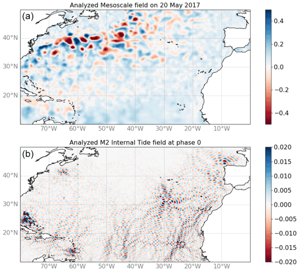
Clément Ubelmann, Loren Carrere, Chloé Durand, Gérald Dibarboure, Yannice Faugère, Maxime Ballarotta, Frédéric Briol, and Florent Lyard
Ocean Sci., 18, 469–481, https://doi.org/10.5194/os-18-469-2022, https://doi.org/10.5194/os-18-469-2022, 2022
Short summary
Short summary
The signature of internal tides has become an important component for high-resolution altimetry over oceans. Several studies have proposed some solutions to resolve part of these internal tides based on the altimetry record. Following these studies, we propose here a new inversion approach aimed to mitigate aliasing with other dynamics. After a description of the methodology, the solution for the main tidal components has been successfully validated against independent observations.
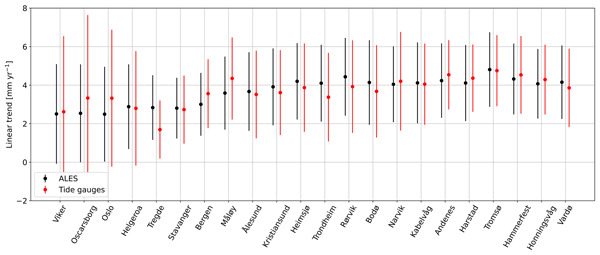
Fabio Mangini, Léon Chafik, Antonio Bonaduce, Laurent Bertino, and Jan Even Ø. Nilsen
Ocean Sci., 18, 331–359, https://doi.org/10.5194/os-18-331-2022, https://doi.org/10.5194/os-18-331-2022, 2022
Short summary
Short summary
We validate the recent ALES-reprocessed coastal satellite altimetry dataset along the Norwegian coast between 2003 and 2018. We find that coastal altimetry and conventional altimetry products perform similarly along the Norwegian coast. However, the agreement with tide gauges slightly increases in terms of trends when we use the ALES coastal altimetry data. We then use the ALES dataset and hydrographic stations to explore the steric contribution to the Norwegian sea-level anomaly.
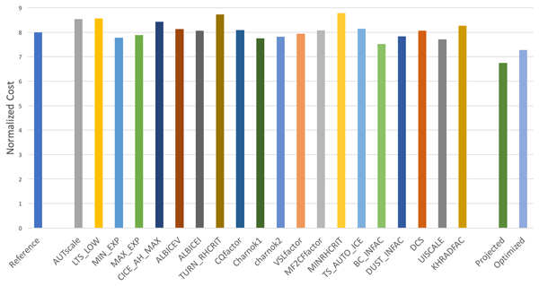
Ehud Strobach, Andrea Molod, Donifan Barahona, Atanas Trayanov, Dimitris Menemenlis, and Gael Forget
Geosci. Model Dev., 15, 2309–2324, https://doi.org/10.5194/gmd-15-2309-2022, https://doi.org/10.5194/gmd-15-2309-2022, 2022
Short summary
Short summary
The Green's functions methodology offers a systematic, easy-to-implement, computationally cheap, scalable, and extendable method to tune uncertain parameters in models accounting for the dependent response of the model to a change in various parameters. Herein, we successfully show for the first time that long-term errors in earth system models can be considerably reduced using Green's functions methodology. The method can be easily applied to any model containing uncertain parameters.

Cori Pegliasco, Antoine Delepoulle, Evan Mason, Rosemary Morrow, Yannice Faugère, and Gérald Dibarboure
Earth Syst. Sci. Data, 14, 1087–1107, https://doi.org/10.5194/essd-14-1087-2022, https://doi.org/10.5194/essd-14-1087-2022, 2022
Short summary
Short summary
The new global Mesoscale Eddy Trajectory Atlases (META3.1exp) provide eddy identification and trajectories from altimetry maps. These atlases comprise an improvement to and continuation of the historical META2.0 product. Changes in the detection parameters and tracking were tested by comparing the eddies from the different datasets. In particular, the eddy contours available in META3.1exp are an asset for multi-disciplinary studies.
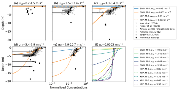
Victor Onink, Erik van Sebille, and Charlotte Laufkötter
Geosci. Model Dev., 15, 1995–2012, https://doi.org/10.5194/gmd-15-1995-2022, https://doi.org/10.5194/gmd-15-1995-2022, 2022
Short summary
Short summary
Turbulent mixing is a vital process in 3D modeling of particle transport in the ocean. However, since turbulence occurs on very short spatial scales and timescales, large-scale ocean models generally have highly simplified turbulence representations. We have developed parametrizations for the vertical turbulent transport of buoyant particles that can be easily applied in a large-scale particle tracking model. The predicted vertical concentration profiles match microplastic observations well.

Mikael L. A. Kaandorp, Stefanie L. Ypma, Marijke Boonstra, Henk A. Dijkstra, and Erik van Sebille
Ocean Sci., 18, 269–293, https://doi.org/10.5194/os-18-269-2022, https://doi.org/10.5194/os-18-269-2022, 2022
Short summary
Short summary
A large amount of marine litter, such as plastics, is located on or around beaches. Both the total amount of this litter and its transport are poorly understood. We investigate this by training a machine learning model with data of cleanup efforts on Dutch beaches between 2014 and 2019, obtained by about 14 000 volunteers. We find that Dutch beaches contain up to 30 000 kg of litter, largely depending on tides, oceanic transport, and how exposed the beaches are.
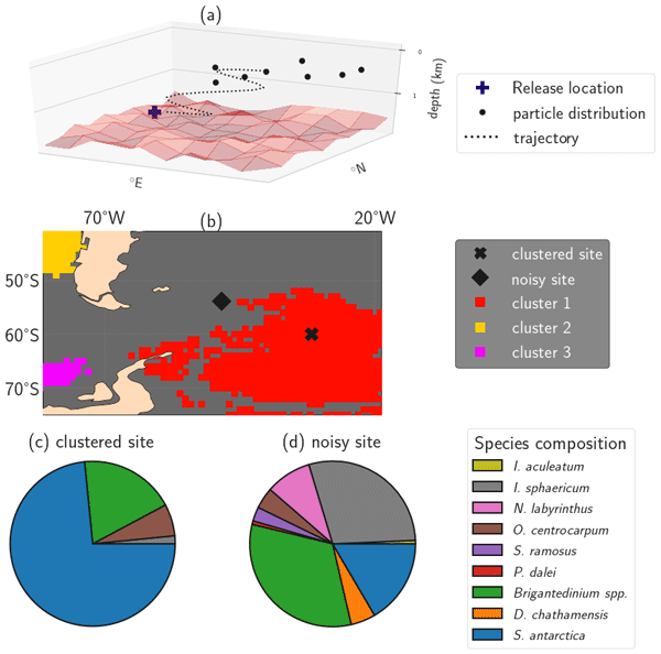
Peter D. Nooteboom, Peter K. Bijl, Christian Kehl, Erik van Sebille, Martin Ziegler, Anna S. von der Heydt, and Henk A. Dijkstra
Earth Syst. Dynam., 13, 357–371, https://doi.org/10.5194/esd-13-357-2022, https://doi.org/10.5194/esd-13-357-2022, 2022
Short summary
Short summary
Having descended through the water column, microplankton in ocean sediments represents the ocean surface environment and is used as an archive of past and present surface oceanographic conditions. However, this microplankton is advected by turbulent ocean currents during its sinking journey. We use simulations of sinking particles to define ocean bottom provinces and detect these provinces in datasets of sedimentary microplankton, which has implications for palaeoclimate reconstructions.
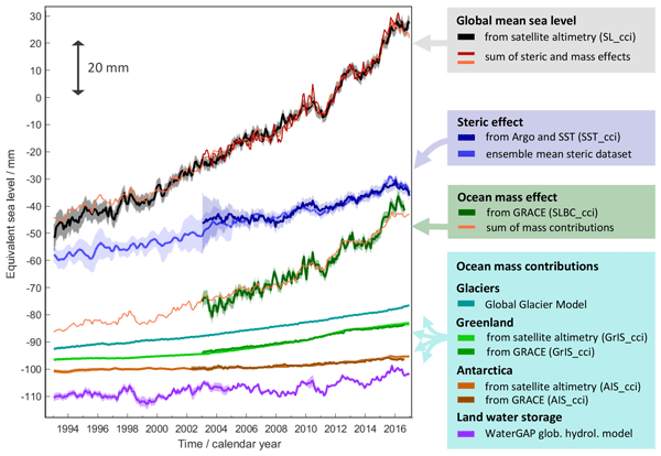
Martin Horwath, Benjamin D. Gutknecht, Anny Cazenave, Hindumathi Kulaiappan Palanisamy, Florence Marti, Ben Marzeion, Frank Paul, Raymond Le Bris, Anna E. Hogg, Inès Otosaka, Andrew Shepherd, Petra Döll, Denise Cáceres, Hannes Müller Schmied, Johnny A. Johannessen, Jan Even Øie Nilsen, Roshin P. Raj, René Forsberg, Louise Sandberg Sørensen, Valentina R. Barletta, Sebastian B. Simonsen, Per Knudsen, Ole Baltazar Andersen, Heidi Ranndal, Stine K. Rose, Christopher J. Merchant, Claire R. Macintosh, Karina von Schuckmann, Kristin Novotny, Andreas Groh, Marco Restano, and Jérôme Benveniste
Earth Syst. Sci. Data, 14, 411–447, https://doi.org/10.5194/essd-14-411-2022, https://doi.org/10.5194/essd-14-411-2022, 2022
Short summary
Short summary
Global mean sea-level change observed from 1993 to 2016 (mean rate of 3.05 mm yr−1) matches the combined effect of changes in water density (thermal expansion) and ocean mass. Ocean-mass change has been assessed through the contributions from glaciers, ice sheets, and land water storage or directly from satellite data since 2003. Our budget assessments of linear trends and monthly anomalies utilise new datasets and uncertainty characterisations developed within ESA's Climate Change Initiative.
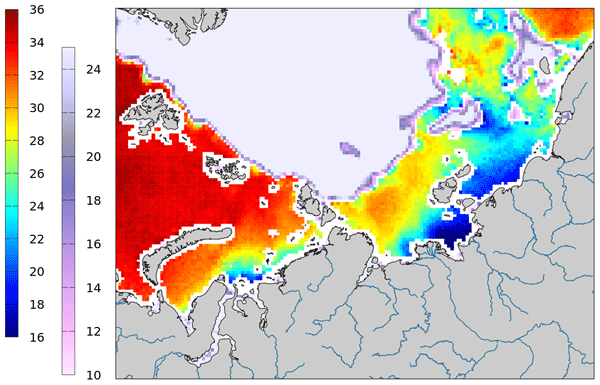
Justino Martínez, Carolina Gabarró, Antonio Turiel, Verónica González-Gambau, Marta Umbert, Nina Hoareau, Cristina González-Haro, Estrella Olmedo, Manuel Arias, Rafael Catany, Laurent Bertino, Roshin P. Raj, Jiping Xie, Roberto Sabia, and Diego Fernández
Earth Syst. Sci. Data, 14, 307–323, https://doi.org/10.5194/essd-14-307-2022, https://doi.org/10.5194/essd-14-307-2022, 2022
Short summary
Short summary
Measuring salinity from space is challenging since the sensitivity of the brightness temperature to sea surface salinity is low, but the retrieval of SSS in cold waters is even more challenging. In 2019, the ESA launched a specific initiative called Arctic+Salinity to produce an enhanced Arctic SSS product with better quality and resolution than the available products. This paper presents the methodologies used to produce the new enhanced Arctic SMOS SSS product.
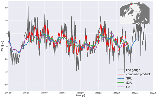
Pierre Prandi, Jean-Christophe Poisson, Yannice Faugère, Amandine Guillot, and Gérald Dibarboure
Earth Syst. Sci. Data, 13, 5469–5482, https://doi.org/10.5194/essd-13-5469-2021, https://doi.org/10.5194/essd-13-5469-2021, 2021
Short summary
Short summary
We investigate how mapping sea level in the Arctic Ocean can benefit from combining data from three satellite radar altimeters: CryoSat-2, Sentinel-3A and SARAL/AltiKa. A dedicated processing for SARAL/AltiKa provides a baseline for the cross-referencing of CryoSat-2 and Sentinel-3A before mapping. We show that by combining measurements coming from three missions, we are able to increase the resolution of gridded sea level fields in the ice-covered Arctic Ocean.

Amy Solomon, Céline Heuzé, Benjamin Rabe, Sheldon Bacon, Laurent Bertino, Patrick Heimbach, Jun Inoue, Doroteaciro Iovino, Ruth Mottram, Xiangdong Zhang, Yevgeny Aksenov, Ronan McAdam, An Nguyen, Roshin P. Raj, and Han Tang
Ocean Sci., 17, 1081–1102, https://doi.org/10.5194/os-17-1081-2021, https://doi.org/10.5194/os-17-1081-2021, 2021
Short summary
Short summary
Freshwater in the Arctic Ocean plays a critical role in the global climate system by impacting ocean circulations, stratification, mixing, and emergent regimes. In this review paper we assess how Arctic Ocean freshwater changed in the 2010s relative to the 2000s. Estimates from observations and reanalyses show a qualitative stabilization in the 2010s due to a compensation between a freshening of the Beaufort Gyre and a reduction in freshwater in the Amerasian and Eurasian basins.
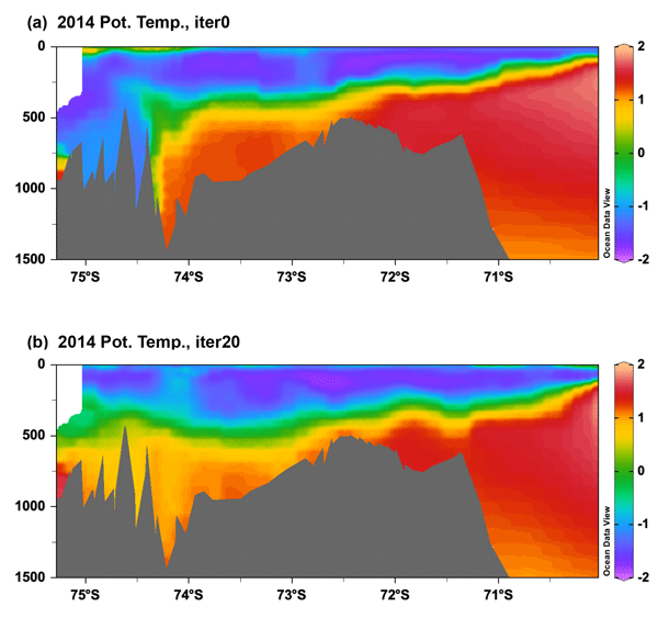
Yoshihiro Nakayama, Dimitris Menemenlis, Ou Wang, Hong Zhang, Ian Fenty, and An T. Nguyen
Geosci. Model Dev., 14, 4909–4924, https://doi.org/10.5194/gmd-14-4909-2021, https://doi.org/10.5194/gmd-14-4909-2021, 2021
Short summary
Short summary
High ice shelf melting in the Amundsen Sea has attracted many observational campaigns in the past decade. One method to combine observations with numerical models is the adjoint method. After 20 iterations, the cost function, defined as a sum of the weighted model–data difference, is reduced by 65 % by adjusting initial conditions, atmospheric forcing, and vertical diffusivity. This study demonstrates adjoint-method optimization with explicit representation of ice shelf cavity circulation.
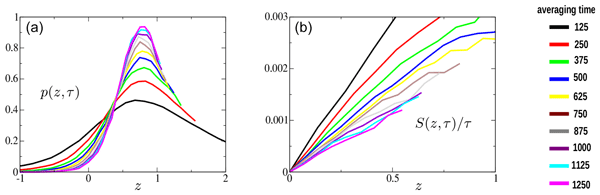
Achim Wirth and Bertrand Chapron
Nonlin. Processes Geophys., 28, 371–378, https://doi.org/10.5194/npg-28-371-2021, https://doi.org/10.5194/npg-28-371-2021, 2021
Short summary
Short summary
In non-equilibrium statistical mechanics, which describes forced-dissipative systems such as air–sea interaction, there is no universal probability density function (pdf). Some such systems have recently been demonstrated to exhibit a symmetry called a fluctuation theorem (FT), which strongly constrains the shape of the pdf. Using satellite data, the mechanical power input to the ocean by air–sea interaction following or not a FT is questioned. A FT is found to apply over specific ocean regions.
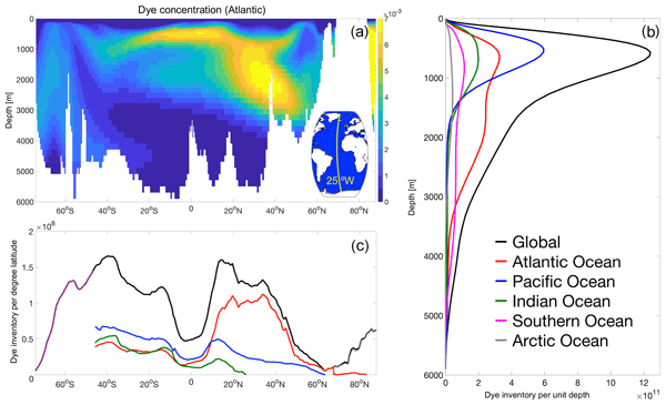
Alice Marzocchi, A. J. George Nurser, Louis Clément, and Elaine L. McDonagh
Ocean Sci., 17, 935–952, https://doi.org/10.5194/os-17-935-2021, https://doi.org/10.5194/os-17-935-2021, 2021
Short summary
Short summary
The ocean absorbs a large proportion of the excess heat and anthropogenic carbon in the climate system. This uptake is modulated by air–sea fluxes and by the processes that transport water from the surface into the ocean’s interior. We performed numerical simulations with interannually varying passive tracers and identified the key role of surface atmospheric forcing in setting the longer-term variability in the distribution of the tracers after they are transported below the ocean’s surface.
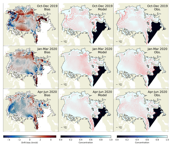
Timothy Williams, Anton Korosov, Pierre Rampal, and Einar Ólason
The Cryosphere, 15, 3207–3227, https://doi.org/10.5194/tc-15-3207-2021, https://doi.org/10.5194/tc-15-3207-2021, 2021
Short summary
Short summary
neXtSIM (neXt-generation Sea Ice Model) includes a novel and extremely realistic way of modelling sea ice dynamics – i.e. how the sea ice moves and deforms in response to the drag from winds and ocean currents. It has been developed over the last few years for a variety of applications, but this paper represents its first demonstration in a forecast context. We present results for the time period from November 2018 to June 2020 and show that it agrees well with satellite observations.
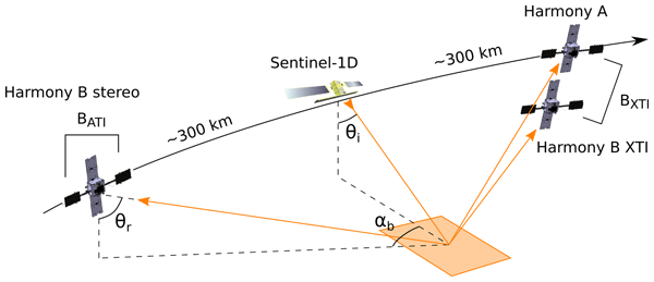
Marcel Kleinherenbrink, Anton Korosov, Thomas Newman, Andreas Theodosiou, Alexander S. Komarov, Yuanhao Li, Gert Mulder, Pierre Rampal, Julienne Stroeve, and Paco Lopez-Dekker
The Cryosphere, 15, 3101–3118, https://doi.org/10.5194/tc-15-3101-2021, https://doi.org/10.5194/tc-15-3101-2021, 2021
Short summary
Short summary
Harmony is one of the Earth Explorer 10 candidates that has the chance of being selected for launch in 2028. The mission consists of two satellites that fly in formation with Sentinel-1D, which carries a side-looking radar system. By receiving Sentinel-1's signals reflected from the surface, Harmony is able to observe instantaneous elevation and two-dimensional velocity at the surface. As such, Harmony's data allow the retrieval of sea-ice drift and wave spectra in sea-ice-covered regions.
Cited articles
Aksenov, Y., Popova, E. E., Yool, A., Nurser, A. G., Williams, T. D., Bertino, L., and Bergh, J.: On the future navigability of Arctic sea routes: High-resolution projections of the Arctic Ocean and sea ice, Marine Policy, 75, 300–317, https://doi.org/10.1016/j.marpol.2015.12.027, 2017.
Ardhuin, F., Marié, L., Rascle, N., Forget, P., and Roland, A.: Observation and estimation of Lagrangian, Stokes and Eulerian currents induced by wind and waves at the sea surface, J. Phys. Oceanogr., 39, 2820–2838, https://doi.org/10.1175/2009JPO4169.1, 2009.
Ardhuin, F., Chapron, B., Collard, F., Smith, M., Stopa, J., Thomson, J., Doble, M., Wadhams, P., Blomquist, B., Persson, O., and Collins III, C. O.: Measuring ocean waves in sea ice using SAR imagery: A quasi-deterministic approach evaluated with Sentinel-1 and in situ data, Remote Sens. Environ., 189, 211–222, https://doi.org/10.1016/j.rse.2016.11.024, 2017a.
Ardhuin, F., Rascle, N., Chapron, B., Gula, J., Molemaker, J., Gille, S. T., Menemenlis, D., and Rocha, C.: Small scale currents have large effects on wind wave heights, J. Geophys. Res., 122, 4500–4517, https://doi.org/10.1002/2016JC012413, 2017b.
Barrick, D. E.: First order theory and analysis of MF/HF/VHF scatter from the sea, IEEE T. Antennas Propagat., AP-20, 2–10, 1972.
Bonjean, F. and Lagerloef, G. S. E.: Diagnostic Model and Analysis of the Surface Currents in the Tropical Pacific Ocean, J. Phys. Oceanogr., 32, 2938–2954, https://doi.org/10.1175/1520-0485(2002)032<2938:DMAAOT>2.0.CO;2, 2002.
Bourassa, M. A., Rodriguez, E., and Chelton, D.: Winds and current mission: Ability to observe mesoscale air/sea coupling, in: Proceedings of IEEE International Geoscience and Remote Sensing Symposium (IGARSS), Beijing, China, 7392–7395, https://doi.org/10.1109/IGARSS.2016.7730928, 2016.
Buck, C.: An extension to the wide swath ocean altimeter concept, in: vol. 8, Proceedings of the IEEE International Geoscience and Remote Sensing Symposium (IGARSS), Seoul, Korea, 543–5439, https://doi.org/10.1109/IGARSS.2005.1525970, 2005.
Cardinali, C., Pezzulli, S., and Andersson, E.: Influence-matrix diagnostic of a data assimilation system, Q. J. Roy. Meteorol. Soc., 130, 2767–2786, 2004.
Caudal, G., Hauser, D., Valentin, R., and Gac, C. L.: KuROS: A New Airborne Ku-Band Doppler Radar for Observation of Surfaces, J. Atmos. Ocean Tech., 31, 2023–2245, https://doi.org/10.1175/JTECH-D-14-00013.1, 2014.
Chapron, B., Collard, F., and Ardhuin, F.: Direct measurements of ocean surface velocity from space: interpretation and validation, J. Geophys. Res., 110, C07008, https://doi.org/10.1029/2004JC002809, 2005.
Collard, F., Mouche, A., Chapron, B., Danilo, C., and Johannessen, J.: Routine High Resolution Observation Of Selected Major Surface Currents From Space, in: Proceedings of SEASAR 2008, SP-656, ESA, ESA – ESRIN, Frascati, Italy, http://earth.esa.int/workshops/seasar2008/participants/287/pres_287_Collard.pdf (last access: 12 April 2018), 2008.
Cravatte, S., Kessler, W. S., Smith, N., Wijffels, S. E., and Contributing Authors: First Report of TPOS 2020, GOOS-215, 200 pp., http://tpos2020.org/first-report/ (last access: 12 April 2018), 2016.
Elfouhaily, T., Chapron, B., Katsaros, K., and Vandemark, D.: A unified directional spectrum for long and short wind-driven waves, J. Geophys. Res., 102, 15781–15796, 1997.
Elipot, S., Lumpkin, R., Perez, R. C., Lilly, J. M., Early, J. J., and Sykulski, A. M.: A global surface drifter data set at hourly resolution, J. Geophys. Res., 121, 2937–2966, https://doi.org/10.1002/2016JC011716, 2016.
Forget, P., Saillard, M., and Broche, P.: Observations of the sea surface by coherent L band radar at low grazing angles in a nearshore environment, J. Geophys. Res., 111, C09015, https://doi.org/10.1029/2005JC002900, 2006.
Forget, P., Saillard, M., Guérin, C.-A., Testud, J., and Bouar, E. L.: On the Use of X-Band Weather Radar for Wind Field Retrieval in Coastal Zone, J. Atmos. Ocean Tech., 82, 899–917, https://doi.org/10.1175/JTECH-D-15-0206.1, 2016.
Fu, L.-L. and Ubelmann, C.: On the Transition from Profile Altimeter to Swath Altimeter for Observing Global Ocean Surface Topography, J. Atmos. Ocean Tech., 31, 560–568, 2014.
Gille, S. T. and Hughes, C. W.: Aliasing of high-frequency variability by altimetry: Evaluation from bottom pressure recorders, Geophys. Res. Lett., 28, 1755–1758, https://doi.org/10.1029/1999GL011263, 2001.
Goldstein, R. M. and Zebker, H. A.: Interferometric radar measurement of ocean surface current, Nature, 328, 707–709, 1987.
Górski, K. M., Hivon, E., Banday, A. J., Wandelt, B. D., Hansen, F. K., Reinecke, M., and Bartelmann, M.: HEALPix: A Framework for High-Resolution Discretization and Fast Analysis of Data Distributed on the Sphere, Astrophys. J., 622, 759–771, https://doi.org/10.1086/427976, 2005.
Gula, J., Molemaker, M. J., and Mcwilliams, J. C.: Gulf Stream Dynamics along the Southeastern U.S. Seaboard, J. Phys. Oceanogr., 45, 690–715, 2015.
Hauser, D., Tison, C., Amiot, T., Delaye, L., Corcoral, N., and Castillan, P.: SWIM: The First Spaceborne Wave Scatterometer, IEEE T. Geosci. Remote, 55, 3000–3014, 2017.
Horvat, C., Tziperman, E., and Campin, J.-M.: Interaction of sea ice floe size, ocean eddies and sea ice melting, Geophys. Res. Lett., 43, 8083–8090, https://doi.org/10.1002/2016GL069742, 2016.
Isern-Fontanet, J., Ballabrera-Poy, J., Turiel, A., and García-Ladona, E.: Remote sensing of ocean surface currents: a review of what is being observed and what is being assimilated, Nonlin. Processes Geophys., 24, 613–643, https://doi.org/10.5194/npg-24-613-2017, 2017.
Jackson, F. C., Walton, W. T., and Peng, C. Y.: A comparison of in situ and airborne radar observations of ocean wave directionality, J. Geophys. Res., 90, 1005–1018, 1985.
Jenkins, A. D.: The use of a wave prediction model for driving a near-surface current model, Deut. Hydrogr. Z., 42, 133–149, 1989.
Johannessen, O. M., Johannessen, J. A., Morison, J., Farrelly, B. A., and Svendsen, E. A. S.: OceanographicC onditionsi n the Marginal Ice Zone North of Svalbard in Early Fall 1979 With an Emphasis on Mesoscale Processes, J. Geophys. Res., 88, 2755–2769, 1983.
Kenyon, K. E.: Stokes drift for random gravity waves, J. Geophys. Res., 74, 6991–6994, 1969.
Kim, S. Y. and Kosro, P. M.: Observations of near-inertial surface currents off Oregon: Decorrelation time and length scales, J. Geophys. Res., 118, 3723–3736, https://doi.org/10.1002/jgrc.20235, 2013.
Kim, S. Y., Terrill, E. J., and Cornuelle, B. D.: Mapping surface currents from HF radar radial velocity measurements using optimal interpolation, J. Geophys. Res., 113, C10023, https://doi.org/10.1029/2007JC004244, 2008.
Kirby, J. T. and Chen, T.-M.: Surface waves on vertically sheared flows: approximate dispersion relations, J. Geophys. Res., 94, 1013–1027, 1989.
Korosov, A. A. and Rampal, P.: A Combination of Feature Tracking and Pattern Matching with Optimal Parametrization for Sea Ice Drift Retrieval from SAR Data, Remote Sensing, 9, 258, https://doi.org/10.3390/rs9030258, 2017.
Kuik, A. J., van Vledder, G. P., and Holthuijsen, L. H.: A method for the routine analysis of pitch-and-roll buoy wave data, J. Phys. Oceanogr., 18, 1020–1034, https://doi.org/10.1175/1520-0485(1988)018<1020:amftra>2.0.co;2, 1988.
Lipa, B. J. and Barrick, D. E.: Least-squares methods for the extraction of surface currents from CODAR crossed-loop data: Application at ARSLOE, IEEE J. Ocean. Eng., 8, 226–253, 1983.
Martin, A. C. H., Gommenginger, C., Marquez, J., Doody, S., Navarro, V., and Buck, C.: Wind-wave-induced velocity in ATI SAR ocean surface currents: First experimental evidence from an airborne campaign, J. Geophys. Res., 121, 1640–1653, https://doi.org/10.1002/2015JC011459, 2016.
Mouche, A. A., Chapron, B., and Reul, N.: Predicted Doppler shifts induced by ocean surface wave displacements using asymptotic electromagnetic wave scattering theories, Waves Random Complex Media, 18, 185–196, https://doi.org/10.1080/17455030701564644, 2008.
Nouguier, F., Chapron, B., Collard, F., Mouche, A., Rascle, N., Ardhuin, F., and Wu, X.: Sea surface kinematics from near-nadir radar measurements, IEEE T. Geosci. Remote, http://tiny.cc/SKIMonRG_NOUG, in press, 2018.
Peureux, C., Benetazzo, A., and Ardhuin, F.: Note on the directional properties of meter-scale gravity waves, Ocean Sci., 14, 41–52, https://doi.org/10.5194/os-14-41-2018, 2018.
Ponte, A. L., Klein, P., Dunphy, M., and Le Gentil, S.: Low-mode internal tides and balanced dynamics disentanglement in altimetric observations: Synergy with surface density observations, J. Geophys. Res., 122, 2143–2155, https://doi.org/10.1002/2016JC012214, 2017.
Poulain, P.-M., Bussani, A., Gerin, R., Jungwirth, R., Mauri, E., Menna, M., and Notarstefano, G.: Mediterranean surface currents measured with drifters: From basin to subinertial scales, Oceanography, 26, 38–47, https://doi.org/10.5670/oceanog.2013.03, 2016.
Raney, R. K.: Doppler properties of radars in circular orbits, Int. J. Remote Sens., 7, 1153–1162, 1986.
Rascle, N. and Ardhuin, F.: A global wave parameter database for geophysical applications. Part 2: model validation with improved source term parameterization, Ocean Model., 70, 174–188, https://doi.org/10.1016/j.ocemod.2012.12.001, 2013.
Rio, M.-H., Mulet, S., and Picot, N.: Beyond GOCE for the ocean circulation estimate: Synergetic use of altimetry, gravimetry, and in situ data provides new insight into geostrophic and Ekman currents, Geophys. Res. Lett., 41, 8918–8925, https://doi.org/10.1002/2014GL061773, 2014.
Rocha, C. B., Chereskin, T. K., and Gille, S. T.: Mesoscale to Submesoscale Wavenumber Spectra in Drake Passage, J. Phys. Oceanogr., 46, 601–620, https://doi.org/10.1175/JPO-D-15-0087.1, 2016.
Roland, A. and Ardhuin, F.: On the developments of spectral wave models: numerics and parameterizations for the coastal ocean, Ocean Dynam., 64, 833–846, https://doi.org/10.1007/s10236-014-0711-z, 2014.
Romeiser, R., Runge, H., Suchandt, S., Kahle, R., Rossi, C., and Bell, P.: Quality Assessment of Surface Current Fields From TerraSAR-X and TanDEM-X Along-Track Interferometry and Doppler Centroid Analysis, IEEE T. Geosci. Remote, 52, 2759–2772, https://doi.org/10.1109/TGRS.2013.2265659, 2014.
Rouault, M. J., Mouche, A., Collard, F., Johannessen, J. A., and Chapron, B.: Mapping the Agulhas Current from space: An assessment of ASAR surface current velocities, J. Geophys. Res., 41, C10026, https://doi.org/10.1029/2009JC006050, 2010.
Sakov, P., Counillon, F., Bertino, L., Lisæter, K. A., Oke, P. R., and Korablev, A.: TOPAZ4: an ocean-sea ice data assimilation system for the North Atlantic and Arctic, Ocean Sci., 8, 633–656, https://doi.org/10.5194/os-8-633-2012, 2012.
Shrira, V. I., Ivonin, D. V., Broche, P., and de Maistre, J. C.: On remote sensing of vertical shear of ocean surface currents by means of a single-frequency VHF radar, Geophys. Res. Lett., 28, 3955–3958, 2001.
SKIM Team: Sea surface KInematics Multiscale monitoring, full proposal for ESA EE9, Tech. rep., Laboratoire d'Océanographie Physique et Spatiale, Brest, France, prepared for European Space Agency, 192 pp., https://doi.org/10.13140/RG.2.2.18902.86084/1, 2017.
Stammer, D., Wunsch, C., and Ponte, R. M.: De-aliasing of global high frequency barotropic motions in altimeter observations, Geophys. Res. Lett., 27, 1175–1176, https://doi.org/10.1029/1999GL011263, 2000.
Stokes, G. G.: On the theory of oscillatory waves, Trans. Camb. Philos. Soc., 8, 441–455, 1849.
Sudre, J., Maes, C., and Garçon, V.: On the global estimates of geostrophic and Ekman surface currents, Limnol. Oceanogr., 3, 1–20, https://doi.org/10.1215/21573689-2071927, 2013.
Sutherland, P. and Gascard, J. C.: Airborne remote sensing of ocean wave directional wavenumber spectra in the marginal ice zone, Geophys. Res. Lett., 43, 4659–4664, https://doi.org/10.1002/grl.53444, 2016.
Thomson, J., D'Asaro, E. A., Cronin, M. F., Rogers, W. E., Harcourt, R. R., and Shcherbina, A.: Waves and the equilibrium range at Ocean Weather Station P, J. Geophys. Res., 118, 595–5962, https://doi.org/10.1002/2013JC008837, 2013.
Ubelmann, C., Cornuelle, B., and Fu, L.-L.: Dynamic Mapping of Along-Track Ocean Altimetry: Method and Performance from Observing System Simulation Experiments, J. Atmos. Ocean Tech., 33, 1691–1699, https://doi.org/10.1175/JTECH-D-15-0163.1, 2016.
van Sebille, E., Wilcox, C., Lebreton, L., Maximenko, N., Hardesty, B. D., van Franeker, J. A., Eriksen, M., Siegel, D., Galgani, F., and Law, K. L.: A global inventory of small floating plastic debris, Environ. Res. Lett., 10, 124006, https://doi.org/10.1088/1748-9326/10/12/124006, 2015.
Wollstadt, S., López-Dekker, P., De Zan, F., and Younis, M.: Design Principles and Considerations for Spaceborne ATI SAR-Based Observations of Ocean Surface Velocity Vectors, IEEE T. Geosci. Remote, 99, 1–20, https://doi.org/10.1109/TGRS.2017.2692880, 2016.
Xie, J., Bertino, L., Counillon, F., Lisæter, K. A., and Sakov, P.: Quality assessment of the TOPAZ4 reanalysis in the Arctic over the period 1991–2013, Ocean Sci., 13, 123–144, https://doi.org/10.5194/os-13-123-2017, 2017.
Yurovsky, Y. Y., Kudryavtsev, V. N., Chapron, B., and Grodsky, S. A.: Sea surface kinematics from near-nadir radar measurements, IEEE T. Geosci. Remote, https://doi.org/10.1109/TGRS.2017.2787459, in press, 2018.
Zrnic, D. S.: Spectral Moment Estimates from Correlated Pulse Pairs, IEEE T. Aero. Elect. Syst., 13, 344–354, https://doi.org/10.1109/TAES.1977.308467, 1977.
Short summary
The Sea surface KInematics Multiscale (SKIM) monitoring mission is a proposal for a future satellite that is designed to measure ocean currents and waves. Using a Doppler radar, the accurate measurement of currents requires the removal of the mean velocity due to ocean wave motions. This paper describes the main processing steps needed to produce currents and wave data from the radar measurements. With this technique, SKIM can provide unprecedented coverage and resolution, over the global ocean.
The Sea surface KInematics Multiscale (SKIM) monitoring mission is a proposal for a future...


