
Articles | Volume 22, issue 5
https://doi.org/10.5194/os-22-2863-2026
© Author(s) 2026. This work is distributed under
the Creative Commons Attribution 4.0 License.
the Creative Commons Attribution 4.0 License.
Special issue:
https://doi.org/10.5194/os-22-2863-2026
© Author(s) 2026. This work is distributed under
the Creative Commons Attribution 4.0 License.
the Creative Commons Attribution 4.0 License.
Research article
| 
24 Sep 2026
Research article |
| 24 Sep 2026
| 24 Sep 2026
Quantitative evaluation of mesoscale eddies in the North Atlantic using satellite altimetry and ocean reanalyses

Institute of Marine Sciences, National Research Council of Italy, Rome, Italy
Department of Physics “E.R. Caianiello”, University of Salerno, Fisciano, Italy
Gregory C. Smith
Meteorological Research Division, Environment and Climate Change Canada (ECCC), Dorval, Canada
Andrea Storto
Institute of Marine Sciences, National Research Council of Italy, Rome, Italy
Chunxue Yang
Institute of Marine Sciences, National Research Council of Italy, Rome, Italy
Related authors
No articles found.
Vincenzo de Toma, Andrea Storto, Ronan McAdam, Antonietta Capotondi, and Chunxue Yang
EGUsphere, https://doi.org/10.5194/egusphere-2026-5747, https://doi.org/10.5194/egusphere-2026-5747, 2026
This preprint is open for discussion and under review for Ocean Science (OS).
Short summary
Short summary
Marine heatwaves, prolonged spells of unusually warm seawater, can harm marine life and the people who depend on it, yet we know little about what happens beneath the surface. We compared three reconstructions of past ocean conditions and found they reliably capture famous surface events seen by satellites. Warm water often extends 100 to 150 metres down, and events reaching deeper last longer. Our results show that combining several products adds value to the results.
Zhe Song, Anny Cazenave, William Llovel, Andrea Storto, and Marie Bouih
Ocean Sci., 22, 2903–2914, https://doi.org/10.5194/os-22-2903-2026, https://doi.org/10.5194/os-22-2903-2026, 2026
Short summary
Short summary
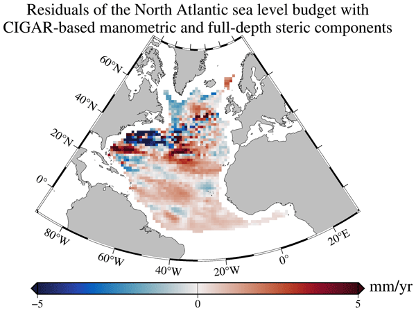
The objective of this study is to understand why the North Atlantic sea level budget is not closed over the Argo and Gravity Recovery and Climate Experiment (GRACE) era. We show that using an ocean reanalysis for the ocean mass component instead of GRACE, and accounting for deep ocean warming allows quasi-closure of the North Atlantic sea level budget within data uncertainties.
Susanna Winkelbauer, Gaël Forget, Michael Mayer, Romain Bourdalle-Badie, Andrea Cipollone, Leopold Haimberger, Keith Haines, Satoshi Osafune, Yuanyuan Song, Andrea Storto, Chunxue Yang, and Hao Zuo
EGUsphere, https://doi.org/10.5194/egusphere-2026-5435, https://doi.org/10.5194/egusphere-2026-5435, 2026
This preprint is open for discussion and under review for Ocean Science (OS).
Short summary
Short summary
Ocean currents carry vast amounts of heat through the Atlantic and strongly influence climate. We compared estimates from 17 global ocean reanalyses with observations to assess how well they reproduce this heat transport and its changes over time. Most reanalyses capture the main patterns and variations, but important differences remain. The reanalyses also suggest a decrease in northward heat transport since the early 1990s, although its magnitude remains uncertain.
Andrea Storto, Vincenzo de Toma, and Chunxue Yang
Ocean Sci., 22, 2809–2834, https://doi.org/10.5194/os-22-2809-2026, https://doi.org/10.5194/os-22-2809-2026, 2026
Short summary
Short summary
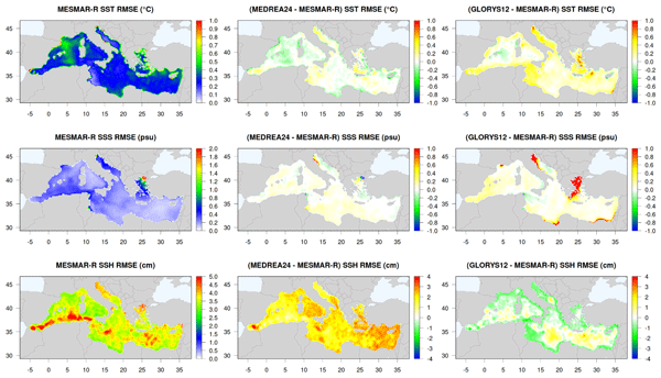
The Mediterranean region is one of the fastest-warming areas on Earth, and understanding its changes is thus crucial. We produced a new reconstruction of the Mediterranean climate for the 1993–2024 period, using a modelling system that combines weather, ocean, and hydrology information with observations. This new reanalysis offers a clearer picture of how the region has been warming, drying, and changing over the past 30 years, supporting better studies of extreme events and climate impacts.
Yushi Morioka, Doroteaciro Iovino, Andrea Cipollone, Andrea Storto, Takeshi Doi, Masami Nonaka, and Swadhin K. Behera
EGUsphere, https://doi.org/10.5194/egusphere-2026-5070, https://doi.org/10.5194/egusphere-2026-5070, 2026
This preprint is open for discussion and under review for The Cryosphere (TC).
Short summary
Short summary
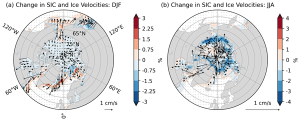
Arctic sea ice has been shrinking for the last four decades. As global warming continues, predicting summer sea ice is becoming more important. Here we create a seasonal forecast system using the SINTEX-F3 model. Results show that summer sea ice in the Barents-Kara Sea is best predicted when accurate sea ice and snow conditions are provided from spring. It is found that initial sea ice thickness acts as a memory for the climate system, enabling accurate summer sea ice prediction from spring.
Kristian Strommen, Michael Mayer, Andrea Storto, Jonas Spaeth, and Steffen Tietsche
Weather Clim. Dynam., 7, 1593–1618, https://doi.org/10.5194/wcd-7-1593-2026, https://doi.org/10.5194/wcd-7-1593-2026, 2026
Short summary
Short summary
Numerical weather forecasts of sea ice are unreliable, exhibiting an overly narrow range of plausible sea ice evolutions. Stochastic perturbations introduce randomness to the forecast in order to alleviate this by representing uncertainties in the representation of sea ice physics. We show that including such perturbations in a forecast model improves the reliability of sea ice forecasts, and furthermore results in improved seasonal forecasts of the northern European winter circulation.
Alejandro Blazquez, Benoit Meyssignac, Robin Fraudeau, Michael Ablain, Jonathan Bamber, Antonio Bonaduce, Marie Bouih, Anny Cazenave, Thorben Döhne, Ines Dussaillant, Ramiro Ferrari, Martin Horwath, Nicolas Kolodziejczyk, Hugo Lecomte, Stephanie Leroux, William Llovel, Daniele Melini, Erwan Oulhen, Thierry Penduff, Roshin P. Raj, Giorgio Spada, Marius Schlaak, Papasarafianou Stamatia, Andrea Storto, Chunxue Yang, and Sarah Connors
Earth Syst. Sci. Data Discuss., https://doi.org/10.5194/essd-2026-627, https://doi.org/10.5194/essd-2026-627, 2026
Preprint under review for ESSD
Short summary
Short summary
Closing the sea‑level budget on annual and longer time scales is a cornerstone of physical oceanography because sea‑level rise is one of the best indicators of climate change, and a closed budget shows we have identified and quantified all major drivers. We examined it from 1993 to 2022, finding an accelerated rise that matched ice melt and warm water until 2015. Afterwards an unexplained gap appears. Better deep‑ocean observations and refined gravity processing are needed to close the budget.
Louis Kern, Thomas Vaujour, Julia Pfeffer, Andrea Storto, Camille Szczypta, Gilles Garric, Claire Sirere, Gilles Larnicol, Chunxue Yang, Romain Bourdalle-Badie, and Stéphanie Guinehut
EGUsphere, https://doi.org/10.5194/egusphere-2025-6351, https://doi.org/10.5194/egusphere-2025-6351, 2026
Short summary
Short summary
Freshwater fluxes, despite their importance, are often poorly represented in ocean models. The impact of river discharge is evaluated from the Water Mass Balance approach, combining gravimetry and atmospheric reanalyses data. These estimates are assessed against river gauges, highlighting good agreement over South American rivers. Compared to climatological data, when used as inputs for ocean model simulations, this technique improves salinity and upper ocean circulation representation.
Alexis Barge, Julien Le Sommer, Andrea Storto, and Sophie Valcke
EGUsphere, https://doi.org/10.5194/egusphere-2026-854, https://doi.org/10.5194/egusphere-2026-854, 2026
Short summary
Short summary
Scientists use programs, called Earth System Models, to study and predict climate. These models are based on physical theories but can be completed with AI tools. However, combining these tools with traditional models is difficult due to their different nature. Our research introduces a new method that connects these AI tools with existing climate models. We tested this method by integrating it with an ocean model. This work should help scientists explore new ways of making climate predictions.
Haohao Zhang, Andrea Storto, Xuezhi Bai, and Chunxue Yang
The Cryosphere, 19, 6807–6826, https://doi.org/10.5194/tc-19-6807-2025, https://doi.org/10.5194/tc-19-6807-2025, 2025
Short summary
Short summary
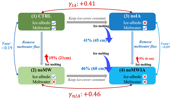
Using a 1D coupled ice-ocean model, we quantified the effects of meltwater and ice-albedo feedback independently. The meltwater reduces melting by 19 % through thermal isolation, while ice-albedo feedback increases melting by 41 %, with nonlinear coupling between them. In winter, meltwater protects ice in weakly stratified areas by blocking Atlantic heat. Our study provides new insights into the relative importance of different components in the Arctic ice-ocean system.
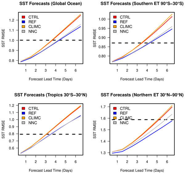
Andrea Storto, Sergey Frolov, Laura Slivinski, and Chunxue Yang
Geosci. Model Dev., 18, 4789–4804, https://doi.org/10.5194/gmd-18-4789-2025, https://doi.org/10.5194/gmd-18-4789-2025, 2025
Short summary
Short summary
Inaccuracies in air–sea heat fluxes severely degrade the accuracy of ocean numerical simulations. Here, we use artificial neural networks to correct air–sea heat fluxes as a function of oceanic and atmospheric state predictors. The correction successfully improves surface and subsurface ocean temperatures beyond the training period and in prediction experiments.
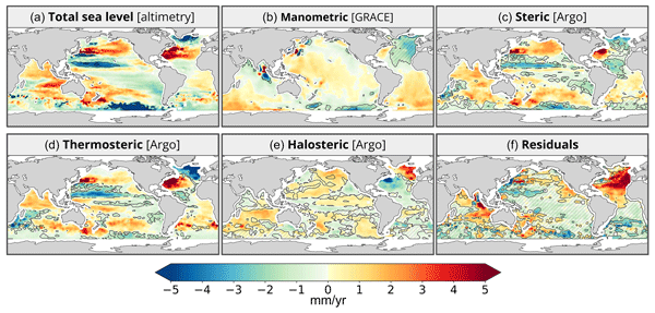
Marie Bouih, Anne Barnoud, Chunxue Yang, Andrea Storto, Alejandro Blazquez, William Llovel, Robin Fraudeau, and Anny Cazenave
Ocean Sci., 21, 1425–1440, https://doi.org/10.5194/os-21-1425-2025, https://doi.org/10.5194/os-21-1425-2025, 2025
Short summary
Short summary
Present-day sea level rise is not uniform regionally. For better understanding of regional sea level variations, a classical approach is to compare the observed sea level trend patterns with those of the sum of the contributions. If the regional sea level trend budget is not closed, this allows the detection of errors in the observing systems. Our study shows that the trend budget is not closed in the North Atlantic Ocean and identifies errors in Argo-based salinity data as the main suspect.
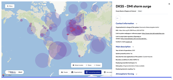
Mauro Cirano, Enrique Alvarez-Fanjul, Arthur Capet, Stefania Ciliberti, Emanuela Clementi, Boris Dewitte, Matias Dinápoli, Ghada El Serafy, Patrick Hogan, Sudheer Joseph, Yasumasa Miyazawa, Ivonne Montes, Diego A. Narvaez, Heather Regan, Claudia G. Simionato, Gregory C. Smith, Joanna Staneva, Clemente A. S. Tanajura, Pramod Thupaki, Claudia Urbano-Latorre, Jennifer Veitch, and Jorge Zavala Hidalgo
State Planet, 5-opsr, 5, https://doi.org/10.5194/sp-5-opsr-5-2025, https://doi.org/10.5194/sp-5-opsr-5-2025, 2025
Short summary
Short summary
Operational ocean forecasting systems (OOFSs) are crucial for human activities, environmental monitoring, and policymaking. An assessment across eight key regions highlights strengths and gaps, particularly in coastal and biogeochemical forecasting. AI offers improvements, but collaboration, knowledge sharing, and initiatives like the OceanPrediction Decade Collaborative Centre (DCC) are key to enhancing accuracy, accessibility, and global forecasting capabilities.
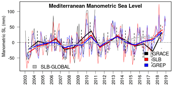
Andrea Storto, Giulia Chierici, Julia Pfeffer, Anne Barnoud, Romain Bourdalle-Badie, Alejandro Blazquez, Davide Cavaliere, Noémie Lalau, Benjamin Coupry, Marie Drevillon, Sebastien Fourest, Gilles Larnicol, and Chunxue Yang
State Planet, 4-osr8, 12, https://doi.org/10.5194/sp-4-osr8-12-2024, https://doi.org/10.5194/sp-4-osr8-12-2024, 2024
Short summary
Short summary
The variability in the manometric sea level (i.e. the sea level mass component) in three ocean basins is investigated in this study using three different methods (reanalyses, gravimetry, and altimetry in combination with in situ observations). We identify the emerging long-term signals, the consistency of the datasets, and the influence of large-scale climate modes on the regional manometric sea level variations at both seasonal and interannual timescales.
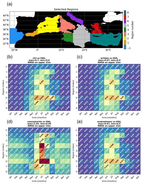
Vincenzo de Toma, Daniele Ciani, Yassmin Hesham Essa, Chunxue Yang, Vincenzo Artale, Andrea Pisano, Davide Cavaliere, Rosalia Santoleri, and Andrea Storto
Geosci. Model Dev., 17, 5145–5165, https://doi.org/10.5194/gmd-17-5145-2024, https://doi.org/10.5194/gmd-17-5145-2024, 2024
Short summary
Short summary
This study explores methods to reconstruct diurnal variations in skin sea surface temperature in a model of the Mediterranean Sea. Our new approach, considering chlorophyll concentration, enhances spatial and temporal variations in the warm layer. Comparative analysis shows context-dependent improvements. The proposed "chlorophyll-interactive" method brings the surface net total heat flux closer to zero annually, despite a net heat loss from the ocean to the atmosphere.
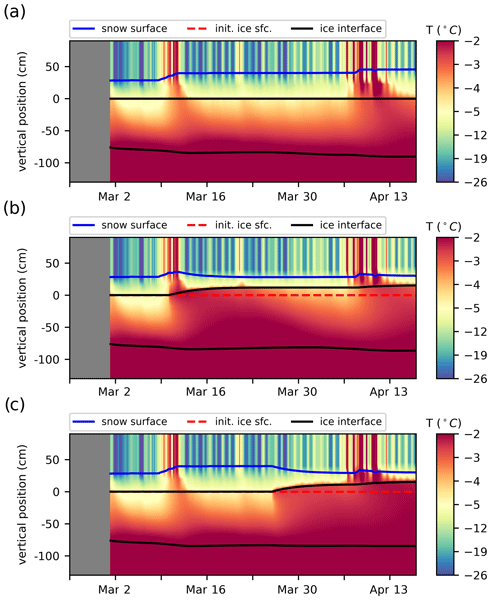
Mathieu Plante, Jean-François Lemieux, L. Bruno Tremblay, Adrienne Tivy, Joey Angnatok, François Roy, Gregory Smith, Frédéric Dupont, and Adrian K. Turner
The Cryosphere, 18, 1685–1708, https://doi.org/10.5194/tc-18-1685-2024, https://doi.org/10.5194/tc-18-1685-2024, 2024
Short summary
Short summary
We use a sea ice model to reproduce ice growth observations from two buoys deployed on coastal sea ice and analyze the improvements brought by new physics that represent the presence of saline liquid water in the ice interior. We find that the new physics with default parameters degrade the model performance, with overly rapid ice growth and overly early snow flooding on top of the ice. The performance is largely improved by simple modifications to the ice growth and snow-flooding algorithms.
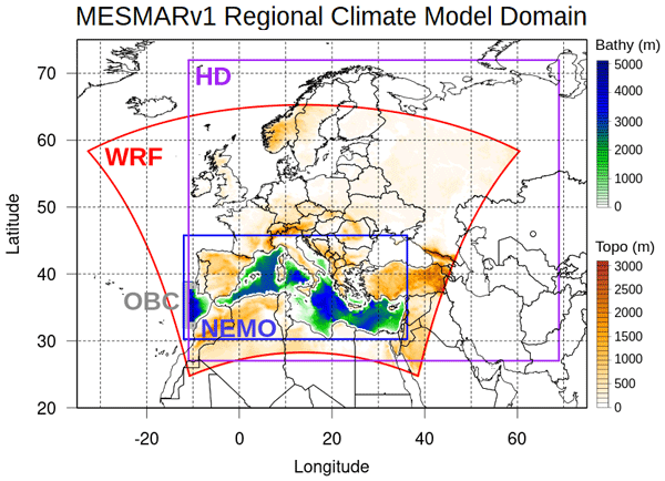
Andrea Storto, Yassmin Hesham Essa, Vincenzo de Toma, Alessandro Anav, Gianmaria Sannino, Rosalia Santoleri, and Chunxue Yang
Geosci. Model Dev., 16, 4811–4833, https://doi.org/10.5194/gmd-16-4811-2023, https://doi.org/10.5194/gmd-16-4811-2023, 2023
Short summary
Short summary
Regional climate models are a fundamental tool for a very large number of applications and are being increasingly used within climate services, together with other complementary approaches. Here, we introduce a new regional coupled model, intended to be later extended to a full Earth system model, for climate investigations within the Mediterranean region, coupled data assimilation experiments, and several downscaling exercises (reanalyses and long-range predictions).
Jean-Philippe Paquin, François Roy, Gregory C. Smith, Sarah MacDermid, Ji Lei, Frédéric Dupont, Youyu Lu, Stephanne Taylor, Simon St-Onge-Drouin, Hauke Blanken, Michael Dunphy, and Nancy Soontiens
EGUsphere, https://doi.org/10.5194/egusphere-2023-42, https://doi.org/10.5194/egusphere-2023-42, 2023
Preprint withdrawn
Short summary
Short summary
This paper present the Coastal Ice-Ocean Prediction System implemented operationally at Environment and climate change Canada. The objective is to enhance the numerical guidance in coastal areas to support electronic navigation and response to environmental emergencies in the aquatic environment. Model evaluation against observations shows improvements for most surface ocean variables in the coastal system compared to current coarser-resolution operational systems.
Cited articles
Abernathey, R. and Haller, G.: Transport by Lagrangian vortices in the eastern Pacific, J. Phys. Oceanogr., 48, 667–685, https://doi.org/10.1175/JPO-D-17-0102.1, 2018.
Amores, A., Jordà, G., Arsouze, T., and Le Sommer, J.: Up to what extent can we characterize ocean eddies using present-day gridded altimetric products?, J. Geophys. Res.-Oceans, 123, 7220–7236, https://doi.org/10.1029/2018JC014140, 2018.
Ballarotta, M., Ubelmann, C., Pujol, M.-I., Taburet, G., Fournier, F., Legeais, J.-F., Faugère, Y., Delepoulle, A., Chelton, D., Dibarboure, G., and Picot, N.: On the resolutions of ocean altimetry maps, Ocean Sci., 15, 1091–1109, https://doi.org/10.5194/os-15-1091-2019, 2019.
Ballarotta, M., Ubelmann, C., Bellemin-Laponnaz, V., Le Guillou, F., Meda, G., Anadon, C., Laloue, A., Delepoulle, A., Faugère, Y., Pujol, M.-I., Fablet, R., and Dibarboure, G.: Integrating wide-swath altimetry data into Level-4 multi-mission maps, Ocean Sci., 21, 63–80, https://doi.org/10.5194/os-21-63-2025, 2025.
Beauchamp, M., Febvre, Q., Georgenthum, H., and Fablet, R.: 4DVarNet-SSH: end-to-end learning of variational interpolation schemes for nadir and wide-swath satellite altimetry, Geosci. Model Dev., 16, 2119–2147, https://doi.org/10.5194/gmd-16-2119-2023, 2023.
Bonaduce, A., Cipollone, A., Johannessen, J. A., Staneva, J., Raj, R. P., and Aydogdu, A.: Ocean mesoscale variability: a case study on the Mediterranean Sea from a re-analysis perspective, Front. Earth Sci., 9, 724879, https://doi.org/10.3389/feart.2021.724879, 2021.
Cabanes, C., Grouazel, A., von Schuckmann, K., Hamon, M., Turpin, V., Coatanoan, C., Paris, F., Guinehut, S., Boone, C., Ferry, N., de Boyer Montégut, C., Carval, T., Reverdin, G., Pouliquen, S., and Le Traon, P.-Y.: The CORA dataset: validation and diagnostics of in-situ ocean temperature and salinity measurements, Ocean Sci., 9, 1–18, https://doi.org/10.5194/os-9-1-2013, 2013.
Ciani, D., Santoleri, R., Liberti, G. L., Prigent, C., Donlon, C., and Buongiorno Nardelli, B.: Copernicus Imaging Microwave Radiometer (CIMR) benefits for the Copernicus Level 4 sea-surface salinity processing chain, Remote Sens., 11, 1818, https://doi.org/10.3390/rs11151818, 2019.
Ciani, D., Fanelli, C., and Buongiorno Nardelli, B.: Estimating ocean currents from the joint reconstruction of absolute dynamic topography and sea surface temperature through deep learning algorithms, Ocean Sci., 21, 199–216, https://doi.org/10.5194/os-21-199-2025, 2025.
Chelton, D. B., Gaube, P., Schlax, M. G., Early, J. J., and Samelson, R. M.: The influence of nonlinear mesoscale eddies on near-surface oceanic chlorophyll, Science, 334, 328–332, https://doi.org/10.1126/science.1208897, 2011a.
Chelton, D. B., Schlax, M. G., and Samelson, R. M.: Global observations of nonlinear mesoscale eddies, Prog. Oceanogr., 91, 167–216, https://doi.org/10.1016/j.pocean.2011.01.002, 2011b.
Chenillat, F., Franks, P. J. S., and Combes, V.: Biogeochemical properties of eddies in the California Current System, Geophys. Res. Lett., 43, 5812–5820, https://doi.org/10.1002/2016GL068945, 2016.
Cullen, V. L.: Columbus Iselin and oceanographic research in the western North Atlantic, Oceanography, 18, 30–33, 2005.
CLS: Global Ocean Gridded L4 Sea Surface Heights and Derived Variables Reprocessed 1993–Ongoing (SEALEVEL_GLO_PHY_L4_MY_008_047), E.U. Copernicus Marine Service Information, Marine Data Store [AVISO DUACS] [data set], https://doi.org/10.48670/moi-00148 (last access: 31 October 2025), 2018.
CLS and CNES: DUACS Experimental Products Handbook: SSALTO/DUACS Level-4 Sea Surface Height and Derived Variables Gridded Products – Including SWOT MIOST Science, Version 1.2, https://www.aviso.altimetry.fr/fileadmin/documents/data/tools/hdbk_duacs_experimental.pdf (last access: April 2025), 2025.
CNES and CLS: Experimental Multimission Gridded (MIOST with SWOT) Level-4 Sea Surface Heights and Velocities, version 2.0.1, CNES/AVISO [SWOT MIOST Science] [data set], https://doi.org/10.24400/527896/A01-2025.001 (last access: 1 November 2025), 2025.
Conti, D., Orfila, A., Mason, E., Sayol, J. M., Simarro, G., and Balle, S.: An eddy tracking algorithm based on dynamical systems theory, Ocean Dynam., 66, 1415–1427, https://doi.org/10.1007/s10236-016-0990-7, 2016.
Copernicus Marine Service: CMEMS-GLO-QUID-001-030: Quality Information Document for Global Ocean Reanalysis Product GLORYS12V1, Mercator Ocean International, https://documentation.marine.copernicus.eu/QUID/CMEMS-GLO-QUID-001-030.pdf (last access: 1 November 2025), 2023.
Copernicus Marine Service: Product User Manual for Sea Level L4 NRT and MY products, CMEMS-SL-PUM-008-046-047-060-068, Issue 1.0, https://documentation.marine.copernicus.eu/PUM/CMEMS-SL-PUM-008-046-047-060-068.pdf (last access: 1 November 2025), 2025a.
Copernicus Marine Service: QUID for Sea Level TAC DUACS products, CMEMS-SL-QUID-008-032-068, Issue 13.0, https://documentation.marine.copernicus.eu/QUID/CMEMS-SL-QUID-008-032-068.pdf (last access: 1 November 2025), 2025b.
Copernicus Marine Service: Synthesis Quality Overview Document for Sea Level Products, CMEMS-SL-SQO-008-033-068, Issue 15.0, https://documentation.marine.copernicus.eu/SQO/CMEMS-SL-SQO-008-033-068.pdf (last access: 21 September 2026), 2026.
Delepoulle, A. and Mason, E.: py-eddy-tracker documentation, https://py-eddy-tracker.readthedocs.io/ (last access: 25 August 2026), 2026.
de Vos, M., Backeberg, B., and Counillon, F.: Using an eddy-tracking algorithm to understand the impact of assimilating altimetry data on the eddy characteristics of the Agulhas system, Ocean Dynam., 68, 1071–1091, https://doi.org/10.1007/s10236-018-1174-4, 2018.
Droghei, R., Buongiorno Nardelli, B., and Santoleri, R.: A new global sea surface salinity and density dataset from multivariate observations (1993–2016), Front. Mar. Sci., 5, 84, https://doi.org/10.3389/fmars.2018.00084, 2018.
EO Portal: SWOT (Surface Water and Ocean Topography) Satellite Mission, https://www.eoportal.org/satellite-missions/swot (last access: 15 April 2026), 2024.
Ezraty, R., Girard-Ardhuin, F., Piollé, J.-F., Kaleschke, L., and Heygster, G.: Arctic and Antarctic sea ice concentration and Arctic sea ice drift estimated from Special Sensor Microwave data, User's manual, Version 2.1, Département d'Océanographie Physique et Spatiale, IFREMER, Brest, France, and Institute of Environmental Physics, University of Bremen, Bremen, Germany, 2007.
Fablet, R., Chapron, B., Drumetz, L., Mémin, E., Pannekoucke, O., and Rousseau, F.: Learning variational data assimilation models and solvers, J. Adv. Model. Earth Sy., 13, e2021MS002572, https://doi.org/10.1029/2021MS002572, 2021.
Faghmous, J. H., Frenger, I., Yao, Y., Warmka, R., Lindell, A., and Kumar, V.: A daily global mesoscale ocean eddy dataset from satellite altimetry, Sci. Data, 2, 150028, https://doi.org/10.1038/sdata.2015.28, 2015.
Fouchet, E., Benkiran, M., Le Traon, P.-Y., and Remy, E.: Comparison of a global high-resolution ocean data assimilation system with SWOT observations, Front. Mar. Sci., 12, 1563934, https://doi.org/10.3389/fmars.2025.1563934, 2025.
Fu, L.-L. and Ubelmann, C.: On the transition from profile altimeter to swath altimeter for observing global ocean surface topography, J. Atmos. Ocean. Tech., 31, 560–568, https://doi.org/10.1175/JTECH-D-13-00109.1, 2014.
Le Guillou, F., Metref, S., Cosme, E., Ubelmann, C., Ballarotta, M., Le Sommer, J., and Verron, J.: Mapping altimetry in the forthcoming SWOT era by back-and-forth nudging a one-layer quasigeostrophic model, J. Atmos. Ocean. Tech., 38, 697–710, https://doi.org/10.1175/JTECH-D-20-0104.1, 2021.
Lellouche, J.-M., Le Galloudec, O., Drévillon, M., Régnier, C., Greiner, E., Garric, G., Ferry, N., Desportes, C., Testut, C.-E., Bricaud, C., Bourdallé-Badie, R., Tranchant, B., Benkiran, M., Drillet, Y., Daudin, A., and De Nicola, C.: Evaluation of global monitoring and forecasting systems at Mercator Océan, Ocean Sci., 9, 57–81, https://doi.org/10.5194/os-9-57-2013, 2013.
Lellouche, J.-M., Greiner, E., Le Galloudec, O., Garric, G., Regnier, C., Drevillon, M., Benkiran, M., Testut, C.-E., Bourdalle-Badie, R., Gasparin, F., Hernandez, O., Levier, B., Drillet, Y., Remy, E., and Le Traon, P.-Y.: Recent updates to the Copernicus Marine Service global ocean monitoring and forecasting real-time 1∕12° high-resolution system, Ocean Sci., 14, 1093–1126, https://doi.org/10.5194/os-14-1093-2018, 2018.
Lellouche, J.-M., Greiner, E., Bourdallé-Badie, R., Garric, G., Melet, A., Drévillon, M., Bricaud, C., Hamon, M., Le Galloudec, O., Regnier, C., Candela, T., Testut, C.-E., Gasparin, F., Ruggiero, G., Benkiran, M., Drillet, Y., and Le Traon, P.-Y.: The Copernicus global
Leroux, S., Brankart, J.-M., Albert, A., Brodeau, L., Molines, J.-M., Jamet, Q., Le Sommer, J., Penduff, T., and Brasseur, P.: Ensemble quantification of short-term predictability of the ocean dynamics at a kilometric-scale resolution: a Western Mediterranean test case, Ocean Sci., 18, 1619–1644, https://doi.org/10.5194/os-18-1619-2022, 2022.
Le Traon, P.-Y. and Morrow, R.: Ocean currents and eddies, in: Satellite Altimetry and Earth Sciences: A Handbook for Techniques and Applications, International Geophysics, 69, edited by: Fu, L.-L. and Cazenave, A., Academic Press, 171–215, https://doi.org/10.1016/S0074-6142(01)80148-0, 2001.
López-Álzate, M. E., Sayol, J.-M., Hernández-Carrasco, I., Osorio, A. F., Mason, E., and Orfila, A.: Mesoscale eddy variability in the Caribbean Sea, Ocean Dynam., 72, 679–693, https://doi.org/10.1007/s10236-022-01525-9, 2022.
Ma, C., Guo, X., Zhang, H., Di, J., and Chen, G.: An investigation of the influences of SWOT sampling and errors on ocean eddy observation, Remote Sens., 12, 2682, https://doi.org/10.3390/rs12172682, 2020.
Madec, G. and Imbard, M.: A global ocean mesh to overcome the North Pole singularity, Clim. Dynam., 12, 381–388, https://doi.org/10.1007/BF00211684, 1996.
Madec, G. and the NEMO System Team: NEMO Ocean Engine Reference Manual, Zenodo [code], https://doi.org/10.5281/zenodo.1464816, 2024.
Martin, M. J., Hoteit, I., Bertino, L., and Moore, A. M.: Data assimilation schemes for ocean forecasting: state of the art, in: Ocean prediction: present status and state of the art (OPSR), edited by: Álvarez Fanjul, E., Ciliberti, S. A., Pearlman, J., Wilmer-Becker, K., and Behera, S., Copernicus Publications, State Planet, 5-opsr, 9, https://doi.org/10.5194/sp-5-opsr-9-2025, 2025.
Mason, E., Pascual, A., and McWilliams, J. C.: A new sea surface height–based code for oceanic mesoscale eddy tracking, J. Atmos. Ocean. Tech., 31, 1181–1188, https://doi.org/10.1175/JTECH-D-14-00019.1, 2014.
Mason, E., Pascual, A., Gaube, P., Ruiz, S., Pelegrí, J. L., and Delepoulle, A.: Subregional characterization of mesoscale eddies across the Brazil-Malvinas Confluence, J. Geophys. Res.-Oceans, 122, 3329–3357, https://doi.org/10.1002/2016JC012611, 2017.
Mason, E., Ruiz, S., Bourdalle-Badie, R., Reffray, G., García-Sotillo, M., and Pascual, A.: New insight into 3-D mesoscale eddy properties from CMEMS operational models in the western Mediterranean, Ocean Sci., 15, 1111–1131, https://doi.org/10.5194/os-15-1111-2019, 2019.
Mauriello, P., Smith, G. C., Storto, A., and Yang, C.: Quantitative evaluation of mesoscale eddies in the North Atlantic: custom analysis scripts, Zenodo [code], https://doi.org/10.5281/zenodo.22814699, 2026.
Mercator Ocean International: Global Ocean Physics Reanalysis (GLOBAL_MULTIYEAR_PHY_001_030), E.U. Copernicus Marine Service Information, Marine Data Store [GLORYS12V1] [data set], https://doi.org/10.48670/moi-00021 (last access: 1 November 2025), 2023.
Mercator Ocean International: Global Ocean Ensemble Physics Reanalysis (GLOBAL_MULTIYEAR_PHY_ENS_001_031), E.U. Copernicus Marine Service Information, Marine Data Store [GLORYS2V4] [data set], https://doi.org/10.48670/moi-00024 (last access: 1 November 2025), 2024.
Morrow, R., Fu, L.-L., Ardhuin, F., Benkiran, M., Chapron, B., Cosme, E., d'Ovidio, F., Farrar, J. T., Gille, S. T., Lapeyre, G., Le Traon, P.-Y., Pascual, A., Ponte, A., Qiu, B., Rascle, N., Ubelmann, C., Wang, J., and Zaron, E. D.: Global observations of fine-scale ocean surface topography with the Surface Water and Ocean Topography (SWOT) mission, Front. Mar. Sci., 6, 232, https://doi.org/10.3389/fmars.2019.00232, 2019.
Mulet, S., Rio, M.-H., Etienne, H., Artana, C., Cancet, M., Dibarboure, G., Feng, H., Husson, R., Picot, N., Provost, C., and Strub, P. T.: The new CNES-CLS18 global mean dynamic topography, Ocean Sci., 17, 789–808, https://doi.org/10.5194/os-17-789-2021, 2021.
Pegliasco, C., Chaigneau, A., Morrow, R., and Dumas, F.: Detection and tracking of mesoscale eddies in the Mediterranean Sea: A comparison between the Sea Level Anomaly and the Absolute Dynamic Topography fields, Adv. Space Res., 68, 401–419, https://doi.org/10.1016/j.asr.2020.03.039, 2021.
Pegliasco, C., Delepoulle, A., Mason, E., Morrow, R., Faugère, Y., and Dibarboure, G.: META3.1exp: a new global mesoscale eddy trajectory atlas derived from altimetry, Earth Syst. Sci. Data, 14, 1087–1107, https://doi.org/10.5194/essd-14-1087-2022, 2022.
Rhines, P. B. and Young, W. R.: Homogenization of potential vorticity in planetary gyres, J. Fluid Mech., 122, 347–367, https://doi.org/10.1017/S0022112082002250, 1982.
Richardson, P. L.: Eddy kinetic energy in the North Atlantic from surface drifters, J. Geophys. Res.-Oceans, 88, 4355–4367, https://doi.org/10.1029/JC088iC07p04355, 1983.
Rogé, M., Morrow, R., Ubelmann, C., and Dibarboure, G.: Using a dynamical advection to reconstruct a part of the SSH evolution in the context of SWOT, application to the Mediterranean Sea, Ocean Dynam., 67, 1047–1066, https://doi.org/10.1007/s10236-017-1073-0, 2017.
Sangrà, P., Pascual, A., Rodríguez-Santana, Á., Machín, F., Mason, E., McWilliams, J. C., Pelegrí, J. L., Dong, C., Rubio, A., Arístegui, J., Marrero-Díaz, Á., Hernández-Guerra, A., Martínez-Marrero, A., and Auladell, M.: The Canary Eddy Corridor: A major pathway for long-lived eddies in the subtropical North Atlantic, Deep-Sea Res. Pt. I, 56, 2100–2114, https://doi.org/10.1016/j.dsr.2009.08.008, 2009.
Souza, J. M. A. C., de Boyer Montégut, C., and Le Traon, P. Y.: Comparison between three implementations of automatic identification algorithms for the quantification and characterization of mesoscale eddies in the South Atlantic Ocean, Ocean Sci., 7, 317–334, https://doi.org/10.5194/os-7-317-2011, 2011.
Smith, G. C. and Fortin, A.-S.: Verification of eddy properties in operational oceanographic analysis systems, Ocean Model., 172, 101982, https://doi.org/10.1016/j.ocemod.2022.101982, 2022.
SWOT Science Team: SWOT Science Data Products User Handbook, NASA/JPL, https://www.earthdata.nasa.gov/s3fs-public/2024-06/D-109532_SWOT_UserHandbook_20240502.pdf (last access: 1 November 2025), 2024.
Szekely, T., Gourrion, J., Pouliquen, S., and Reverdin, G.: CORA, Coriolis Ocean Dataset for Reanalysis, SEANOE [data set], https://doi.org/10.17882/46219, 2019.
Taburet, G., Sanchez-Roman, A., Ballarotta, M., Pujol, M.-I., Legeais, J.-F., Fournier, F., Faugere, Y., and Dibarboure, G.: DUACS DT2018: 25 years of reprocessed sea level altimetry products, Ocean Sci., 15, 1207–1224, https://doi.org/10.5194/os-15-1207-2019, 2019.
Thoppil, P. G., Frolov, S., Rowley, C. D., Reynolds, C. A., Jacobs, G. A., Metzger, E. J., Hogan, P. J., Barton, N., Wallcraft, A. J., Smedstad, O. M., and Shriver, J. F.: Ensemble forecasting greatly expands the prediction horizon for ocean mesoscale variability, Commun. Earth Environ., 2, 89, https://doi.org/10.1038/s43247-021-00151-5, 2021.
Ubelmann, C., Klein, P., and Fu, L.-L.: Dynamic interpolation of sea surface height and potential applications for future high-resolution altimetry mapping, J. Atmos. Ocean. Tech., 32, 177–184, https://doi.org/10.1175/JTECH-D-14-00152.1, 2015.
Ubelmann, C., Cornuelle, B., and Fu, L.-L.: Dynamic mapping of along-track ocean altimetry: Method and performance from observing system simulation experiments, J. Atmos. Ocean. Tech., 33, 1691–1699, https://doi.org/10.1175/JTECH-D-15-0163.1, 2016.
Ubelmann, C., Dibarboure, G., Gaultier, L., Ponte, A., Ardhuin, F., Ballarotta, M., and Faugère, Y.: Reconstructing ocean surface current combining altimetry and future spaceborne Doppler data, J. Geophys. Res.-Oceans, 126, e2020JC016560, https://doi.org/10.1029/2020JC016560, 2021.
Walsh, K.: Objective detection of tropical cyclones in high-resolution analyses, Mon. Weather Rev., 125, 1767–1779, https://doi.org/10.1175/1520-0493(1997)125<1767:ODOTCI>2.0.CO;2, 1997.
Wang, G., Zhao, B., Qiao, F., and Zhao, C.: Rapid intensification of Super Typhoon Haiyan: the important role of a warm-core ocean eddy, Ocean Dynam., 68, 1649–1661, https://doi.org/10.1007/s10236-018-1217-x, 2018.
Wu, C., Lee, C., and Lin, I.: The effect of the ocean eddy on tropical cyclone intensity, J. Atmos. Sci., 64, 3562–3578, https://doi.org/10.1175/JAS4051.1, 2007.
Xie, J., de Vos, M., Bertino, L., Zhu, J., and Counillon, F.: Impact of assimilating altimeter data on eddy characteristics in the South China Sea, Ocean Model., 155, 101704, https://doi.org/10.1016/j.ocemod.2020.101704, 2020.
Xu, X., McClean, J. L., and Moore, A. M.: Assessing the predictability of mesoscale eddies in the Southern California Current System using an ensemble of regional ocean model simulations, Ocean Model., 122, 35–50, https://doi.org/10.1016/j.ocemod.2017.12.005, 2018.
Yang, C., Bricaud, C., Drévillon, M., Storto, A., Bellucci, A., and Santoleri, R.: The role of eddies in the North Atlantic decadal variability, Front. Mar. Sci., 9, 781788, https://doi.org/10.3389/fmars.2022.781788, 2022.
Yang, C., Bourdallé-Badie, R., Drevillon, M., Amaya, D., Aouf, L., Aydogdu, A., Barton, B., Bell, M., Boyer, T., Blauw, A., Carton, J., Candela, T., Cossarini, G., Dabrowski, T., de Boisseson, E., de Mora, L., Fablet, R., Forget, G., Fujii, Y., Garric, G., Giunta, V., Salamon, P., Hersbach, H., Juza, M., Le Sommer, J., Martin, M., McAdam, R., Menendez Garcia, M., Morim, J., Nicolì, D., Reppucci, A., Samuelsen, A., Sauzède, R., Slivinski, L., Specq, D., Storto, A., Tuomi, L., Vandenbulcke, L., Aznar, R., Beuvier, J., Cipollone, A., Clementi, E., Di Biagio, V., Escudier, R., Giesen, R., Greiner, E., Guihou, K., Korabel, V., Lamouroux, J., Law Chune, S., Lellouche, J.-M., Levier, B., Lima, L., Mangin, A., Mayer, M., Melet, A., Miraglio, P., Oikonomou, C., Pfeffer, J., Renshaw, R., Ringgaard, I., Thual, S., Titaud, O., Tonani, M., van Gennip, S., von Schuckmann, K., Drillet, Y., and Le Traon, P.-Y.: Gathering users and developers to shape together the next-generation ocean reanalyses, B. Am. Meteorol. Soc., 106, E419–E429, https://doi.org/10.1175/BAMS-D-24-0034.1, 2025.
Yang, C., Bourdallé-Badie, R., and Drévillon, M.: The Marine Environment Reanalyses Evaluation Project MER-EP: towards an improved knowledge of the global ocean environment of the past decades, to support ocean applications and ocean prediction, EGU General Assembly 2026, Vienna, Austria, 3–8 May 2026, EGU26-9403, https://doi.org/10.5194/egusphere-egu26-9403, 2026.
Zadra, A., McTaggart-Cowan, R., Vaillancourt, P. A., Roch, M., Bélair, S., and Leduc, A.-M.: Evaluation of tropical cyclones in the Canadian global modeling system: Sensitivity to moist process parameterization, Mon. Weather Rev., 142, 1197–1220, https://doi.org/10.1175/MWR-D-13-00124.1, 2014.
Zhang, Z., Wang, W., and Qiu, B.: Oceanic mass transport by mesoscale eddies, Science, 345, 322–324, https://doi.org/10.1126/science.1252418, 2014.
Short summary
This article evaluates two ocean reanalyses with spatial resolutions of 1/4° and 1/12° by comparing them with two satellite observation products, both at 1/8° resolution. The results show the added value of higher model resolution for representing mesoscale eddies and highlight the value of wide-swath satellite altimetry for model verification in the North Atlantic.
This article evaluates two ocean reanalyses with spatial resolutions of 1/4° and 1/12° by...


Special issue