the Creative Commons Attribution 4.0 License.
the Creative Commons Attribution 4.0 License.
 | 14 Jul 2025
Satellite altimetry and operational oceanography: from Jason-1 to SWOT
Pierre-Yves Le Traon
Gérald Dibarboure
Jean-Michel Lellouche
Marie-Isabelle Pujol
Mounir Benkiran
Marie Drevillon
Yann Drillet
Yannice Faugère
Elisabeth Remy
The development and evolution of satellite altimetry and operational oceanography are very closely linked. By providing all weather, global, and real-time observations of sea level, a key variable to constrain ocean analysis and forecasting systems, satellite altimetry has had a profound influence on the advancement of operational oceanography. Over the past 20 years, satellite altimetry has been providing a continuous observation of the ocean in near-real time. From the launch of Jason-1 in 2001 to the launch of SWOT in 2022, satellite altimetry capabilities have been regularly improved through refinements of geophysical corrections and processing algorithms, including real-time processing, as well as through the evolution of altimeter radar technology (synthetic aperture radar (SAR) mode, swath altimetry). Resolution has also improved through the use of multiple altimeters and, now, swath altimetry. In parallel, major improvements in ocean prediction systems have occurred, from the Global Data Assimilation Experiment (GODAE) demonstration in the 2000s to the fully operational systems now serving a large range of applications in the 2020s. This paper provides an overview of the development and evolution of satellite altimetry and operational oceanography over the past 20 years in the context of the Mercator Ocean prediction centre, DUACS (data unification and altimeter combination system), and the EU Copernicus Marine Service. The impact of altimetry on the performances of ocean prediction systems (based on observing-system evaluations (OSEs) and observing-system simulation experiments (OSSEs)) is reviewed. The future contribution of swath altimetry to ocean prediction is also discussed. Prospects for the next decade are addressed as part of our conclusions.
- Article
(3254 KB) - Full-text XML
- BibTeX
- EndNote


The launch of TOPEX/Poseidon (T/P) in 1992 was a breakthrough in the development of satellite altimetry. Thanks to a fully optimized altimeter mission, the large-scale sea level and ocean circulation variations were observed for the first time from space. This led to many discoveries (see Fu and Cazenave, 2001). The ERS-1 and ERS-2 missions flew together with T/P and provided complementary sampling required to monitor the mesoscale circulation. The harmonization, intercalibration, and combination of the T/P with ERS-1 and ERS-2 (Ducet et al., 2000) constituted a major step towards developing the use of satellite altimetry in models (see Le Traon, 2013). The launch of Jason-1 in 2001 was subsequently a major milestone, starting a series of highly precise long-term reference missions (following T/P) with near-real-time processing capabilities. Since then, the ocean has been continuously monitored through multiple altimeter missions (Fig. 1).
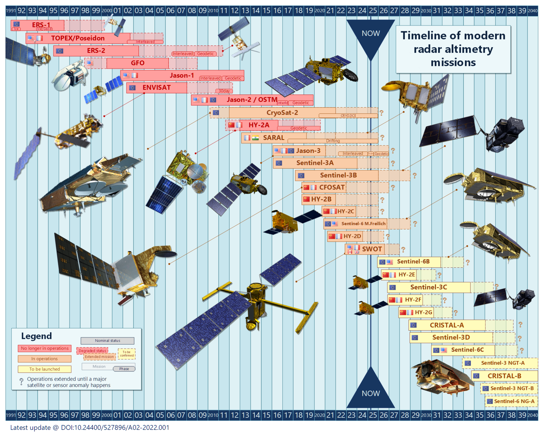
Figure 1Timeline of modern radar altimetry missions. Adapted from Aviso+ (2022). Timeline of modern altimetry. See https://doi.org/10.24400/527896/A02-2022.001, version 03/2024.
The development of global operational oceanography started with the Global Data Assimilation Experiment (GODAE) (Smith and Lefebvre, 1997) and its operational demonstration in the early 2000s (Le Traon et al., 2001; Bell et al., 2009). The demonstration was phased in with the Jason-1 and ENVISAT altimeter missions that provided the required real-time observations of the global ocean. The start of Argo, the global array of profiling floats, was required to provide the essential complementary observations of the ocean interior (Roemmich et al., 2001). Following GODAE, operational oceanography systems have been developed from global to regional and coastal scales (e.g. Bell et al., 2015; Metzger et al., 2014; Chassignet et al., 2018; Hirose et al., 2019). There have been major advancements in operational oceanography systems. The resolution of global ocean analysis and forecasting systems has increased by a factor of at least 3 – from 1/4 to 1/12° – or more now (e.g. Lellouche et al., 2018). Regional systems have reached a resolution of a few kilometres (e.g. Francis et al., 2020; Ciliberti et al., 2022). Models now use high-frequency atmospheric forcing (<3 h), tidal forcing, and improved ocean–wave–atmosphere coupling. More advanced data assimilation techniques have been developed, with better characterization of model error covariances, including the use of ensemble approaches. All of these improvements have led to better use of altimeter data in models.
The development of the altimeter constellation has been an important driver for the evolution of the operational oceanography systems. Satellite altimetry plays a prominent role in constraining ocean models through data assimilation (e.g. Le Traon et al., 2017). It provides global, real-time, all-weather sea level measurements with high spatial and temporal resolutions. Sea level is an integral aspect of the ocean interior properties (sea level is related to depth-integrated density perturbations and barotropic motions) and is a strong constraint for inferring the 4D ocean circulation through data assimilation. Only altimetry can constrain the 4D mesoscale circulation in ocean models, which is required for most operational oceanography applications. The use of multiple altimeter missions has been a common feature of all operational oceanography systems (see Le Traon et al., 2017). Major progress has been made with regard to ensuring the homogenization, intercalibration, and real-time and/or delayed-mode processing of altimeter missions before data are assimilated into models in either forecast or reanalysis mode (e.g. Dibarboure et al., 2011; Pujol et al., 2016). Assimilation of altimeter data into models requires precise mean dynamic topographies (MDTs) to reference the altimeter sea level anomaly (SLA) observations. MDTs have been greatly improved thanks to the use of GOCE and GRACE geoid data and in situ observations (e.g. Rio et al., 2014; Mulet et al., 2021).
This paper reviews the joint development of satellite altimetry and operational oceanography over the past 20 years. It is organized as follows. Section 2 provides an overview of the development and evolution of satellite altimetry and operational oceanography from the perspectives of DUACS (data unification and altimeter combination system), Mercator Ocean, and the EU Copernicus Marine Service. The impact of altimetry on the performances of ocean prediction systems (based on observing-system evaluations (OSEs) and observing-system simulation experiments (OSSEs)) is reviewed in Sect. 3. Section 4 discusses the future contribution of swath altimetry to ocean prediction. Prospects for the next decade are presented in Sect. 5.
An overview of the development of the altimeter constellation, altimeter data processing systems, and operational oceanography is given in the next sections. This overview extends previous syntheses given in Dibarboure et al. (2011) and Le Traon et al. (2017). It focuses on capabilities developed in the framework of the EU Copernicus Marine Service, DUACS, and the Mercator Ocean prediction centre.
2.1 Altimeter constellation
The minimum requirement for operational oceanography is three to four missions, sometimes more if one takes into account the inevitable data outages and anomalies that happen during the lifetimes of all satellites (Le Traon et al., 2017). Dibarboure and Lambin (2015) explain that constellation efficiency is not just related to the number of altimeters. Indeed, one needs to consider the time needed before an altimeter becomes operational (also known as the commissioning phase or calibration–validation phase), as well as satellite sampling redundancy (Dibarboure and Morrow, 2016): two altimeters operating on similar orbits might provide duplicate measurements (e.g. tandem phase of Jason-3 and Sentinel-6MF). Moreover, some altimeter missions are not optimized for operational oceanography because, for example, they use geodetic orbits, have non-optimal payloads for orbit determination, or lack a microwave radiometer or dual-frequency system. Some satellites “of opportunity” can provide sea surface height but with a larger error budget or degraded coverage with respect to operational missions.
In that context, there have been considerable changes in the radar altimeter constellation over the past 15 years in terms of both the number of satellites and the technology. From 2010 to 2015, the altimeter constellation was in a very fragile state, and operational oceanography relied primarily on non-operational altimeters. In 2012, altimeters from the first couple of modern generations had been decommissioned, and only Jason-2 remained. Thanks to the coordinated efforts of space agencies and operational oceanography, the critical number of three to four satellites (Le Traon et al., 2017) was secured with CRYOSAT-2 (a cryosphere-oriented altimeter mission) and Haiyang-2A (China's first technology demonstrator) and then with SARAL (the first Ka-band altimeter technology demonstrator from France and India). Despite periodic data outages (Fig. 2), the constellation proved to be sufficiently robust to maintain decent observational quality for the operational models.
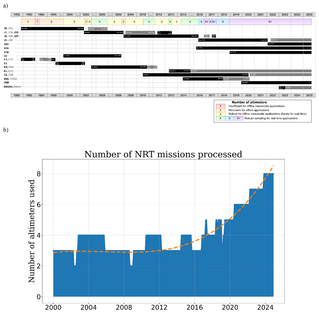
Figure 2Evolution of the number of altimeter missions injected into the Copernicus Sea Level Thematic Assembly Centre (also known as DUACS). Panel (a) is for the offline and/or reprocessed products, and panel (b) is for the monthly availability used for the near-real-time product. Adapted from Ballarotta et al. (2025b).
From 2014 onwards, the subsequent generation of operational missions progressively strengthened the constellation. By the late 2010s, Jason-3 and Sentinel-3A provided the critical core observation in addition to the aforementioned satellites “of opportunity”, and new additions replaced ageing satellites (e.g. Haiyang-2B replaced its predecessor). About six or seven satellites were always active (Fig. 2a), although one or two were kept as backup in operational systems (on standby, qualified for service, with known limitations or complexity). In the early 2020s, the numbers went up again as older satellites were still working nominally while the following generation joined the constellation (Haiyang-2B and Haiyang-2C, Jason-CS/Sentinel-6 Michael Freilich, and SWOT). At the time of writing this paper, there were 11 altimeters in operation: one-third were from the operational Copernicus programme in Europe, one-third were from the Haiyang programme from China, and the others were technology demonstrators.
In the coming years, the constellation should remain very solid as new satellites are about to be launched to replace older missions (Sentinel-3C, Sentinel-6B, Haiyang-2E) until the next generation of missions takes over (CRISTAL, Sentinel-3NG, Sentinel-6NG) within the next 10 years. In that context, ocean prediction systems can expect to obtain not only the minimum coverage needed to carry out their mission but also denser observational coverage able to resolve scales that are finer in space or in time (Ballarotta et al., 2019; Pujol et al., 2023), as well as backup missions ready to be activated if some satellites were to die unexpectedly.
The past decade has also been transformational for satellite altimetry in terms of technology. The CRYOSAT-2 satellite demonstrated that delay–Doppler (synthetic aperture radar mode or SARM) was beneficial over the ocean and not just the cryosphere. It also allowed the research community to explore the benefits of cross-track interferometry in a very narrow swath. The demonstration carried out with CRYOSAT-2 culminated in the activation of synthetic aperture radar (SAR) mode for the global ocean with Sentinel-3A and Sentinel-3B. As Doppler altimetry processors were improving (e.g. Moreau et al., 2021), delay–Doppler altimetry made another leap with Sentinel-6MF and its so-called “interleaved” mode (e.g. concurrent Jason-class and SARM products, fully focused SAR for coastal applications). In parallel, the Ka band was successfully validated with the SARAL mission. Verron et al. (2021) report a smaller footprint and less noise. SARAL paved the way for the CRISTAL missions combining the Ku band and Ka band, as well as for SWOT's Ka-band radar interferometer (KaRIn).
Furthermore, in comparison with these incremental improvements (better performance and better resolution), the most impactful change happened in 2023 with SWOT's first large-swath altimeter (Morrow et al., 2019; Fu et al., 2024). It demonstrated not only a major gain in coverage (equivalent to 50-altimeters-worth of pixels) but also an order of magnitude gained in terms of precision with respect to nadir altimetry. This new technology proved to be directly useful for ocean prediction (e.g. Tchonang et al., 2021; Benkiran et al., 2025), as well as indirectly beneficial with regard to research: new mean sea surface models, new bathymetry (e.g. Yu et al., 2024), better understanding of internal tides (e.g. Tchilibou et al., 2025), better coverage for new barotropic tides, and small-scale and sub-mesoscale processes. This impactful change comes with a series of challenges ranging from the validation of this new type of measurement to the blending of very different technologies in a consistent system (Dibarboure et al., 2025). To that extent, SWOT is expected to unlock various improvements that will be beneficial to older nadir altimeters (e.g. reprocessing with better tide model or mean sea surface models). At the time of writing this paper, swath altimetry was also the main candidate technology for the next generation of Sentinel-3 missions (S3NG) from the Copernicus programme, while Doppler and the Ka band are the baselines for other operational missions.
2.2 Evolution of the DUACS altimeter data processing system
Since the early 2000s, DUACS (data unification and altimeter combination system) has served as the primary multi-mission altimeter data centre providing high-quality, near-real-time, and delayed-mode global and regional altimeter products to the scientific community and operational oceanography. The main processing steps are product homogenization, data editing, orbit error correction, reduction of long-wavelength errors, and production of along-track and maps of sea level anomalies (SLA) and absolute dynamic topographies. A comprehensive description of DUACS is given in Dibarboure et al. (2011) and Pujol et al. (2016). Since 2014, the Copernicus Marine Sea Level and Wave Thematic Assembly Centres have been part of the DUACS altimeter data processing system.
The DUACS sea level system has been designed to address three primary objectives: the provision of L3 products dedicated to assimilation into numerical models and the restitution of mesoscale signals, notably for the Copernicus Marine Service (CMEMS), and the restitution of climatic scales, notably for the Copernicus Climate Change Service (C3S).
Several factors contribute to the quality and relevance of the products: the number of altimeters considered, the choice of retracking standards, the various geophysical and environmental corrections applied to the altimeter measurements, the choice of L3 and L4 processing algorithms (e.g. improved selection of valid data, denoising, new mapping methods, addition of variables of interest), and the physical content of the products. The main evolution of processing capabilities and the level-2, level-3, and level-4 data products that are relevant to operational oceanography and its applications are summarized below.
Over the years, several iterations of reprocessing of L2 input products have been carried out to take into account new retracking, instrumental corrections, or new geophysical and environmental correction solutions. Similarly, a complete reprocessing of the L3 and L4 series has been carried out. A detailed analysis of the new products and standards available is carried out to select those that will best meet the objectives of the Copernicus Marine and Climate Change services (e.g. Kocha et al., 2024). Similarly, the L3 and L4 processing algorithms are reviewed and adjusted for each reprocessing, particularly with regard to parameter evolution and data interpolation methods. Four versions of the reprocessed series have been delivered since 2010. They are identified as “DT-2014” (Pujol et al., 2016), “DT-2108” (Taburet et al., 2019), “DT-2021” (Faugère et al., 2022), and “DT-2024” (Pujol et al., 2024a). These were followed by an upgrade of near-real-time (NRT) production to bring it in line with the same standards and treatments. The various product versions have SLA errors that are reduced in the L4 mesoscale product (wavelengths between 65 and 500 km) by 35 % in areas of high variability, compared with the previous version (DT-2010) (Pujol et al., 2024b). Improvements to ocean tide models (Carrere et al., 2016, 2023) and representations of mean sea surface (MSS) (e.g. Schaeffer et al., 2012, 2023; Pujol et al., 2018; Laloue et al., 2025) represent an important part of the improvement in data quality, particularly in coastal areas (Kocha et al., 2024, 2025). Another area of improvement is the refinement of the mapping processing, with the initial evolution of the optimal-interpolation (OI) parameters at global and regional scales (Pujol et al., 2016; Taburet et al., 2019; Faugère et al., 2022) and, subsequently, the implementation of a new Multiscale Inversion of Ocean Surface Topography (MIOST) mapping process (MIOST; Ubelmann et al., 2021; Ballarotta et al., 2023) that allows for the definition of covariances associated with various surface dynamical processes (rather than the single-scale covariance function used in the OI methodology). In the current version of the L4 product (i.e. DT-2024), the average spatial resolution of the global gridded SLA is around 180 km at mid-latitudes, with larger values near the Equator (∼500 km) and finer values at the poles (∼100 km). Compared with the previous version of DT-2014 (discussed in Ballarotta et al., 2019), the effective spatial resolution has been improved by almost 10 % at mid-latitudes, with the bulk of the improvements being made by changes in the DT-2024 version, with a significant improvement induced by the MIOST mapping method. Note that, as mapping methods are designed to map anomalies relative to a zero mean, data selected for a given grid point estimation are re-centred before the L4 mapping. Mean bias is then reinjected into the solution. The integrity of large-scale spatial and temporal signals (e.g. ocean level trends) is thus ensured.
By exploiting the tandem phases between two successive reference missions, it is possible to correct the sea level biases observed between two missions on a regional scale. This correction, essential for sea level rise monitoring, has been re-estimated and refined over the years (Kocha et al., 2024, 2025; Cadier et al., 2025). In parallel, certain measurement anomalies, which have a substantial impact on sea level rise monitoring, are corrected at the L3 level. One of the main corrections consists of an empirical correction of the TOPEX-A measurement drift, estimated by comparison with in situ measurements (Ablain et al., 2017). Wave-dependent biases in Sentinel-6A high-resolution (HR) and long-resolution (LR) measurements have also been empirically estimated for correction at L3, while the origin of these anomalies is now corrected at L2 (Kocha et al., 2024). Finally, the levels of uncertainty in the estimation of the mean sea level trend on a global and regional scale are regularly reviewed (Ablain et al., 2009, 2019; Prandi et al., 2021a; Guérou et al., 2023). All of these processes help to reduce uncertainty levels and better highlight the acceleration of sea level rise, as discussed, for example, in von Schuckmann et al. (2024).
L3 sea level products used for data assimilation have evolved over the years. Since 2015, the L3 product has included several variables required for optimum assimilation into ocean prediction systems. The L3 product now contains not only the sea level anomalies and absolute dynamic heights but also the various geophysical corrections applied to the data (like ocean tide, dynamic atmospheric correction, and long-wavelength errors). This allows modellers to re-inject this signal into the assimilated data to better match its physical content to that of the model and, thus, to better constrain their model (see Sect. 3).
Since November 2023, a major milestone in the evolution of DUACS products has also been reached, with an increase in product resolution. The NRT sea level system now takes the 20 Hz initial resolution data as input rather than the 1 Hz resolution data previously used. This was made possible by the advances in altimeter techniques and processing, such as the synthetic aperture radar (SAR) measurement mode, which allows for a significant reduction in measurement noise (e.g. by about 30 %, as underlined by Raynal et al., 2018). Additionally, specific empirical noise mitigation corrections enable the reduction of measurement noise in conventional low-resolution-mode (LRM) measurements (Tran et al., 2021). This improves the ability to observe coastal and small mesoscale signals (Pujol et al., 2023). Unlike the historical 1 Hz processing, the 20 Hz noise-filtering processing is reviewed to optimally filter the measurements at the regional scale, taking into account the specific observing capability of each mission (up to 40 km for Sentinel-6A, i.e. locally up to one-third compared with the conventional 1 Hz product). The L3 product defined with 5 Hz sampling, i.e. slightly more than 1 km between two consecutive measurements, is a good compromise between the sampling needs and observing capabilities. The development of this product was motivated by the necessity of addressing the increasing resolution of ocean models (see the discussions in Sects. 2.4 and 3 and in Pujol et al., 2023).
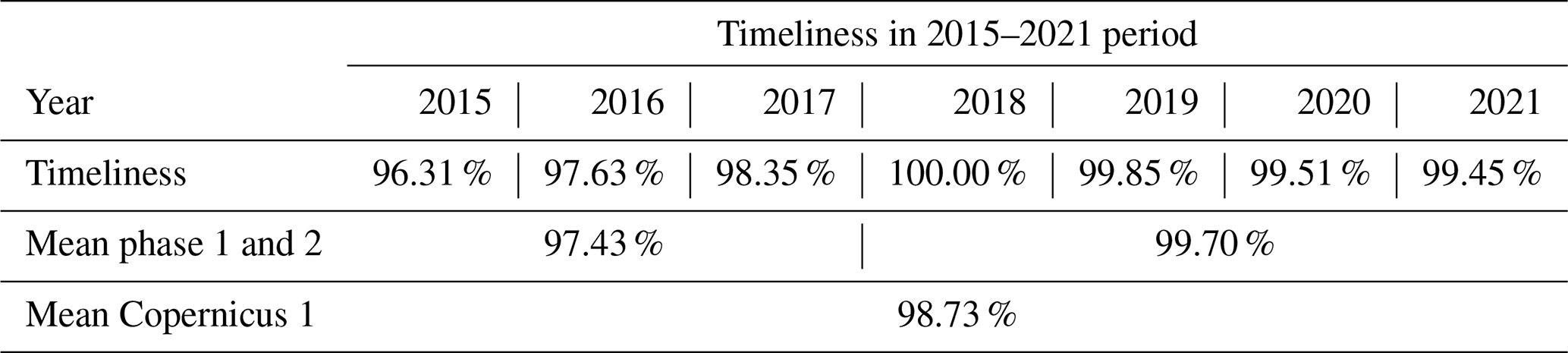
DUACS has also been improved to reduce real-time data availability timeliness. In 2009, modifications were implemented in the production of L3 DUACS data to account for the mesoscale content of fast-delivery upstream L2 products (OGDR/NTR). The availability of these data is limited to a few hours after measurement, yet they enable operational applications to retrieve useful information on the last day or two of measurement, depending on the mission. This enhancement has been demonstrated to reduce errors in multi-mission products by 20 % (Dibarboure et al., 2009). Secondly, the system has undergone continuous upgrades to facilitate the rapid processing of all data. Despite the increase in the number of altimetry missions to be processed (three to four missions in 2015 compared with eight in 2024) and the augmented data volume associated with the enhanced resolution, the optimal data availability time was nearly 96 % in 2015. It has persisted above 99 % since 2018 (Table 1).
Table 1Copernicus Marine Sea Level Thematic Assembly Centre product timeliness over the 2015–2021 period. The timeliness criterion represents the percentage of availability of the daily production over a quarter. The mean timeliness values for Copernicus 1 phase 1 (2015–2017), Copernicus 1 phase 2 (2018–2021), and Copernicus 1 (2015–2021) are also given.
Future sea level products
The increased resolution of the products, with data processed directly at 20 Hz, also enables us to prepare for future DUACS products, particularly in polar and coastal regions where the altimeter signal and the geophysical corrections applied to it are contaminated by the presence of ice and/or land. Since the 2010s, several studies have highlighted the need to specifically process data from ice fracture zones to extract surface level measurements in these areas while ensuring signal continuity with the open ocean (e.g. Prandi et al., 2021b). These treatments have recently been taken into account by space agencies for the generation of future L2 products. More recently, several studies have demonstrated the feasibility of multi-mission L3 and L4 treatments in polar zones (Prandi et al., 2021b; Auger et al., 2022; Veillard et al., 2024). Such products are likely to become part of the Copernicus Marine Service catalogue in the coming years. Similarly, the quality of altimetry measurements in coastal areas requires the application of specifically selected corrections (e.g. Birol et al., 2025) and is greatly enhanced by the use of innovative techniques such as SAR (Vignudelli et al., 2011).
Finally, the launch of SWOT-KaRIn in December 2022 (see above), with its exceptional spatial sampling and its ability to improve the various fields involved in processing altimetry measurements, should greatly enhance all DUACS sea level products in the near future. First-demonstration L3 and L4 products are already available (Dibarboure et al., 2025; Ballarotta et al., 2025a).
2.3 Evolution of mean dynamic topography
One fundamental requirement for assimilating SLA into ocean models is accurate knowledge of the mean dynamic topography (MDT) (Le Traon et al., 2017). MDT is the difference between the mean sea surface (MSS) and the Earth geoid, and, as such, it constitutes, to within a constant and with some remaining uncertainties, the missing link between the observed sea level anomalies and the modelled sea surface heights. Thanks to more than 30 years of altimetry observations and dedicated geodetic phases and/or geodetic missions, the MSS is known with centimetre accuracy at spatial scales down to a few kilometres (see Schaeffer et al., 2023, for a recent update). Thanks to the GOCE and GRACE gravity missions, knowledge of the geoid at scales of 100–150 km has greatly improved (Flechtner et al., 2014), such that the ocean MDT is now resolved at those scales with centimetre accuracy. However, the true ocean MDT contains scales shorter than 100–150 km. To compute higher-resolution MDT, gravity mission data can be combined with altimetry and in situ measurements such as temperature and salinity profiles from the Argo array and velocity measurements from drifting buoys (e.g. Rio and Hernandez, 2004). Over the past years, a series of new MDTs has been produced from global to regional scales. They all benefit from improved input data, such as a better-quality geoid (e.g from EGM96 (Lemoine et al., 1998) to GOCO06S (Kvas et al., 2021)) and MSS data (e.g from MSS CNES_CLS_01 (Hernandez and Schaeffer, 2002) to MSS_CNES_CLS_2022 (Schaeffer et al., 2023)), the availability of more in situ data accumulated over time, and the evolution of processing methods. The main changes are as follows: the inclusion of T–S (temperature–salinity) profile data at different reference depths, the estimation of mean currents in the equatorial band (MDT CNES_CLS_2009; Rio et al., 2011), improved drifter data processing (MDT CNES_CLS_2013; Rio et al., 2014), changing the altimeter reference period to centre the MDT in the 20-year period of [1993, 2012] (MDT CNES_CLS_2013), and using surface current measurements from high-frequency radars (MDT CNES_CLS_2022) (Caballero et al., 2020; Jousset et al., 2023).
The Mercator Ocean analysis and forecasting systems use “hybrid” MDTs (e.g. Hamon et al., 2019; Lellouche et al., 2021) where iterative corrections of the first guess of an MDT derived from gravimetry and in situ observations are performed using high-resolution reanalysis system outputs, updates to the GOCE geoid, and an improved post-glacial rebound (also called glacial isostatic adjustment). The main advantage is the reduction of MDT errors in coastal and high-latitude regions (close to sea ice), the ability to ensure the consistency of the MDT with model dynamics, and the obtainment of an MDT at the model resolution.
2.4 Operational oceanography and ocean prediction
Major improvements in ocean prediction systems have occurred in the period from the GODAE (Global Data Assimilation Experiment) demonstration (Smith and Lefebvre, 1997) in the 2000s to the fully operational systems that now serve a large range of applications in the 2020s. Ocean modelling and data assimilation systems operationally assimilate in situ and satellite data to provide regular and systematic reference information on the physical state, variability, and dynamics of the ocean and marine biogeochemistry from global to coastal scales (e.g. Chassignet et al., 2018; Le Traon et al., 2019; Heimbach et al., 2019; Fennel et al., 2019). Products serve a wide range of applications and downstream services (e.g. Bell et al., 2015; Le Traon et al., 2019, 2021; Schiller et al., 2019).
The French contribution to GODAE began in the late 1990s with the development of the Mercator Ocean centre, the Coriolis partnership for the in situ component (including Argo), and the development of the Jason series with CNES (the French space agency). Mercator Ocean issued its first operational bulletin of the Atlantic in 2001. The year 2005 was a major milestone, with the start of the first global ocean prediction system at a 1/4° resolution (Drévillon et al., 2008). Since then, Mercator Ocean analysis and forecasting global systems have continuously evolved (Lellouche et al., 2013, 2018, 2023) in the framework of the MyOcean European research projects and the Copernicus Marine Service (Fig. 3).
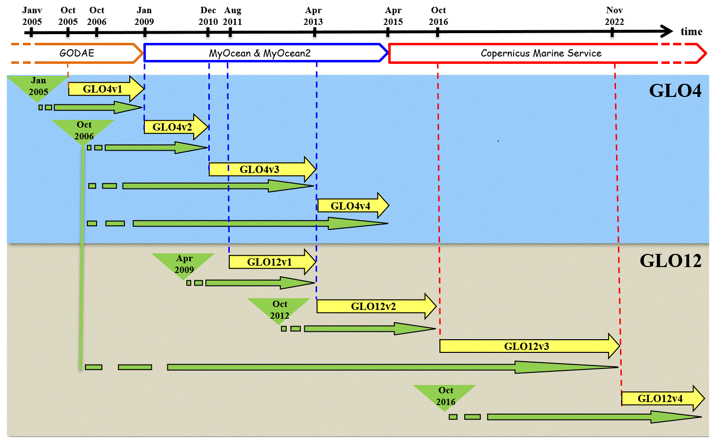
Figure 3Timeline of the Mercator Ocean global analysis and forecasting systems for the various milestones in the past: GODAE, MyOcean projects, and the current Copernicus Marine Service. Real-time productions are in yellow, with the reference being the Mercator Ocean system. Available Mercator Ocean simulations are in green, including the catchup to real time. Global systems at 1/4° (1/12°) are referred to as GLO4 (GLO12).
Since its creation, Mercator Ocean has adopted a strategy of incremental improvement of its assimilation schemes. The initial version consisted of a reduced-order optimal interpolation scheme which had proved its efficiency for the assimilation of altimetry data (Ferry et al., 2007). The SLA increment was split into baroclinic and barotropic contributions using statistical information from the system. The barotropic component was then converted into an increment of the horizontal velocity and barotropic stream function of the model, while the baroclinic part was converted into vertical corrections of temperature and salinity by lifting or lowering of the isopycnals with a method derived from Cooper and Haines (1996), which were then converted into geostrophic current increments. This scheme was then improved to be able to assimilate satellite observations (altimetry and surface temperature) together with in situ observations (expendable bathythermograph – XBT – profilers) in a multivariate and/or multi-data version for regional or basin-scale operational systems. The second generation of the Mercator Assimilation System is based on a SEEK (singular evolutive extended Kalman filter) analysis kernel (Brasseur and Verron, 2006). Compared with the previous version, its main feature is its improved representation of the background error by means of a 3D multivariate error subspace, which has helped to overcome some of the limitations identified in the previous scheme, such as its unsuitability for shallow areas and tropical oceans and the difficulty of optimally controlling the surface layer. The formulation of the SEEK analysis kernel is also characterized by its greater efficiency in processing large quantities of observations. The first version of this tool also included two major parameterizations, specifically a local approach for the analysis and an adaptive scheme for the background variance, improving the consistency of the error statistics for the filter input. The initial version of this assimilation scheme was deployed progressively from 2007 onwards on all Mercator Ocean forecasting and reanalysis systems. It was updated significantly in 2010–2011 (Lellouche et al., 2013) and now forms the main data assimilation tool of the current Mercator Ocean systems.
Mercator Ocean now operates a global real-time monitoring and forecasting system at 1/12°, hereafter referred to as GLO12v4 (Lellouche et al., 2023), and regularly produces and upgrades a global ocean reanalysis at 1/12°, hereafter referred to as GLORYS12 (Lellouche et al., 2021). Both systems are based on a NEMO model configuration and assimilate along-track altimetry observations from the Copernicus Marine Sea Level Thematic Assembly Centre (TAC), satellite sea surface temperature, in situ temperature, and salinity vertical profiles and satellite sea ice concentration. A regional system (IBI (real time) and IBIRYS (reanalysis)) that includes tidal forcing covers the northeastern Atlantic with a higher (1/36°) resolution. All these integrating systems use a 7 d assimilation window, and the forecasting systems deliver daily 10 d forecasts. The increments coming from the analysis are applied progressively using the incremental analysis update (IAU) method (Benkiran and Greiner, 2008), which makes it possible to avoid model shock every week due to the imbalance between the analysis increments and the model physics and results in an optimal and continuous model trajectory. Moreover, all of these system evolutions have required a very significant increase in the computing and storage capacities needed to carry out the developments and to produce real-time forecasts and reanalyses. Computing and storage capacities remain a major challenge but allow for an increase in resolution and for the development of ensemble approaches for the global system (see Sect. 5).
The main evolution of Mercator Ocean global operational ocean prediction systems from 2005 to 2024 is summarized in Table 2. The evolution of the performance of the global system at 1/12° (from v1 to v4) (Fig. 4) shows a gradual improvement from one version to the next. This highlights the system advances in terms of error reduction compared to altimetric observations.
Table 2Evolution of the Mercator Ocean global ocean prediction systems at 1/4° (GLO4) and 1/12° (GLO12) since 2005. In bold are the major upgrades with respect to the previous version. Available and operational production periods are described in Fig. 3.
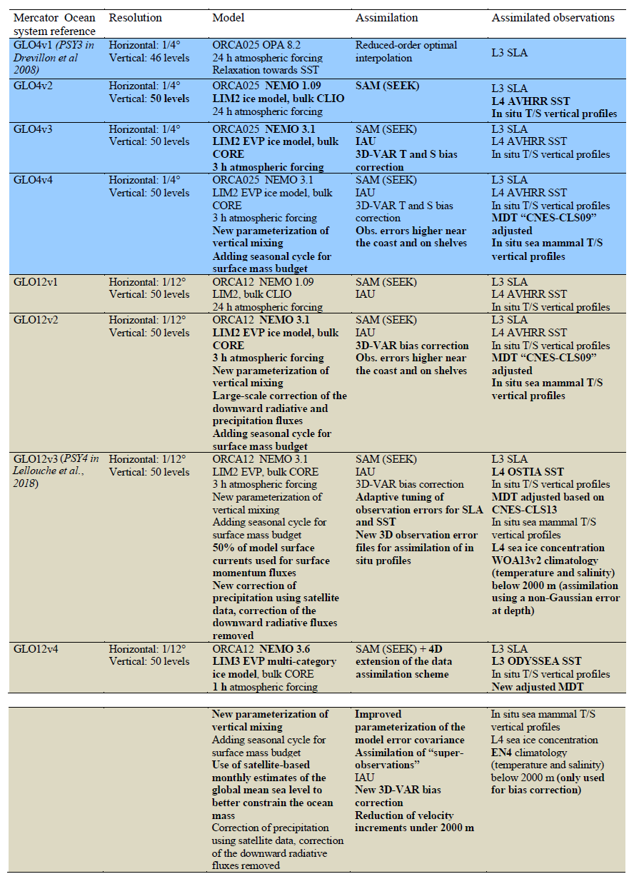
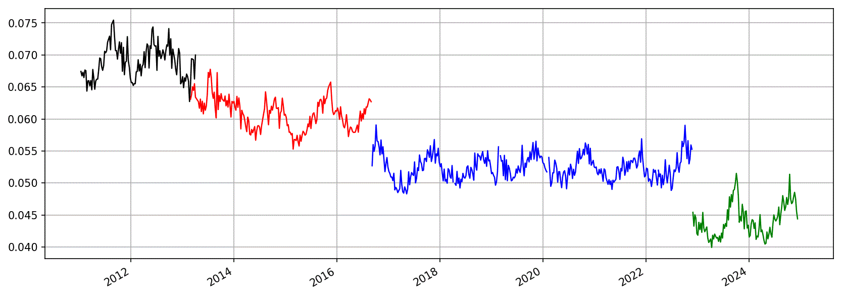
Figure 4Evolution of the performance of the global Mercator Ocean high-resolution prediction system since 2011 (root mean square (rms) of the difference between sea level modelled fields and altimeter observations for the four versions of the Mercator Ocean 1/12° system). The colour indicates the version of the system (GLO12v1 in black, GLO12v2 in red, GLO12v3 in blue, and GLO12v4 in green), and units are metres. From Pinardi et al. (2024).
From 2005, most of the ocean prediction developments, including the ones of Mercator Ocean, have been carried out in Europe in the framework of the Copernicus Marine Service and its precursor R&D projects (Mersea and MyOcean) (e.g. Johannessen et al., 2006; Le Traon et al., 2019). The Copernicus Marine Service (see Le Traon et al., 2021, for a review of past achievements) now provides the EU with a world-leading, reference operational oceanography service on the physical and biogeochemical ocean and sea ice state of the world ocean and EU regional seas. All Copernicus Marine Monitoring and Forecasting Centres (MFCs) provide quality-controlled reanalyses, analyses, and 10 d forecasts and assimilate altimeter data (sea level and significant wave height) from the Copernicus Marine Sea Level and Wave Thematic Assembly Centres. Copernicus Marine contributes directly to the EU's marine and maritime-related policies and supports applications dealing with maritime safety, sustainable use of marine resources, healthy waters, coastal and marine hazard services, ocean climate services, and protection of marine biodiversity (see https://marine.copernicus.eu/services/use-cases, last access: 2 December 2024). More than 90 000 expert services and users worldwide are connected to the service.
3.1 Methods to assess the impact of altimetry for ocean prediction
The monitoring of the impact of observations is a central function of an ocean prediction centre. This is done through observing-system evaluations (OSEs) and observing-system simulation experiments (OSSEs) (e.g. Fujii et al., 2019; Tchonang et al., 2021). OSEs allow for the assessment of the impact of an existing data set on the performances of an ocean prediction system (by withholding observations). OSSEs provide a comprehensive virtual framework to help in designing new observing systems, evaluating their different configurations, and performing preparatory data assimilation work. Alternative and complementary approaches (e.g. computation of forecast sensitivity-based observation impacts) (see Fujii et al., 2019) also exist but are less commonly used in operational oceanography, mostly because they require an adjoint or an ensemble data assimilation scheme (e.g. Drake et al., 2023).
From OSEs and OSSEs, different metrics are used to compare assimilation results (analyses and forecasts) with a reference (e.g. a truth run for OSSEs, independent or non-assimilated data sets or a reference run for OSEs). This includes calculating error variances for full fields (e.g. sea surface height, currents, temperature, salinity) or for special spectral bands, F/W spectra of errors (for OSSEs), normalized spectra, coherence analysis, resolved scales, and/or Lagrangian analyses (e.g. D'Addezio et al., 2019; Jacobs et al., 2021; Tchonang et al., 2021). In addition to verifying the efficiency of the assimilation scheme in reducing the misfit to the assimilated observations, those diagnostics highlight how different unobserved regions and variables and which spatial and temporal scales are improved thanks to the additional information in terms of observations (e.g. Gasparin et al., 2023). Lagrangian analyses provide more insights into the benefits for applications related to the drifts of tracers such as pollutants or plastic debris.
3.2 Main results and findings
A high resolution from multiple altimeters is required to adequately represent ocean eddies and associated currents in models. Both observing-system evaluations (OSEs) (e.g. Hamon et al., 2019) and observing-system simulation experiments (OSSEs) (e.g. Verrier et al., 2017) demonstrate the major contribution of altimetry. The new generation of nadir altimeters now provides enhanced capability thanks to a synthetic aperture radar (SAR) mode that reduces measurement noise. Verrier et al. (2018) demonstrated that the use of multiple SAR altimeter missions with high-resolution models will improve the capability of ocean analysis and forecasting systems. Gasparin at al. (2023) highlighted the complementary role of satellites and in situ observations in constraining the large-scale and mesoscale variability and the need for high-resolution altimeter observations to constrain the mesoscale.
At least four altimeters are required to constrain modelling and data assimilation systems. This is particularly true with high-resolution data assimilation systems. As an illustration, Fig. 5 shows the impact of the assimilation of a fourth altimeter's (S3-A) data into the GLO12v3 system (International Altimetry Team, 2021). Two runs were performed over a 1-month period (May 2017) (International Altimetry Team, 2021): one with the assimilation of Jason-3, SARAL/AltiKa, and CryoSat-2 and one with the assimilation of S3A, Jason-3, SARAL/AltiKa, and CryoSat-2. Adding a fourth altimeter allowed for a reduction in the variance of 7 d forecast errors by about 10 %. Forecast errors are reduced by up to 7 cm in terms of the root mean square (rms) in western boundary currents. Adding more altimeters always has a positive effect on system performance, although the effect decreases as more altimeters are added. For example, analysis error variances (estimated by comparison with a non-assimilated nadir altimeter) are typically reduced by 10 %–15 % when moving from three to six altimeters.
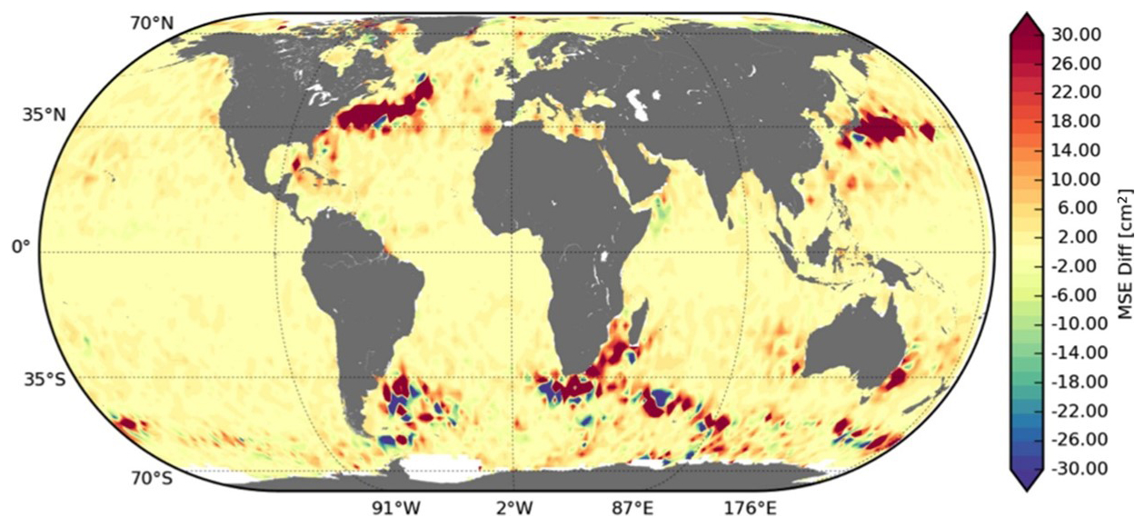
Figure 5Forecast error reduction due to the assimilation of Sentinel-3A data, in addition to Jason-3, SARAL/AltiKa, and CryoSat-2, into the Mercator Ocean 1/12° global system.
Accurate knowledge of the mean dynamic topography (MDT) is a fundamental element for assimilation into ocean models. Hamon et al. (2019) showed that, in terms of impact on sea level, assimilating an updated release of the MDT is comparable to assimilating a fourth altimeter. Gasparin et al. (2021) documented the impact of MDT errors on equatorial dynamics and biogeochemical (BGC) models. Thanks to new and improved altimetric, in situ, and gravimetric (GRACE and GOCE satellite missions) data, MDTs are regularly updated, leading to considerable improvements in both forecasts and analyses (see Sect. 2).
The 1 Hz L3 along-track SLA Copernicus Marine Sea Level product has recently been updated with a new 5 Hz L3 product (see Sect. 2.2). To highlight the impact of these 5 Hz (L3) altimeter data on the global forecast system, an OSE was carried out with the GLO12v4 system. Two simulations were carried out over a period of 5 months, one with 1 Hz SLA data and the other with the 5 Hz data. The assimilation of SLA data at 5 Hz, with improved filtering approaches, was shown to provide a significant improvement in the analyses and forecasts (reduction in variance errors by a few percent). This will be implemented in the operational production by the end of 2025.
Today, seven altimeters are assimilated routinely into the current Mercator Ocean 1/12° operational system GLO12v4. Figure 6 shows the time evolution over the 2017–2024 period of the SLA innovations (differences between observations and background model first trajectory) for the different assimilated altimeters. This misfit is consistent in time and across different altimeters. The mean (over the global ocean) innovation shows that the system is lower than the observations by around 1 to 2 mm on average and that the global rms difference rarely exceeds 5.5 cm. The seasonal cycle in the innovation rms is also observed in the SLA variability and is most likely to be related to the evolution of the altimeter coverage due to the ice cover in the Arctic.
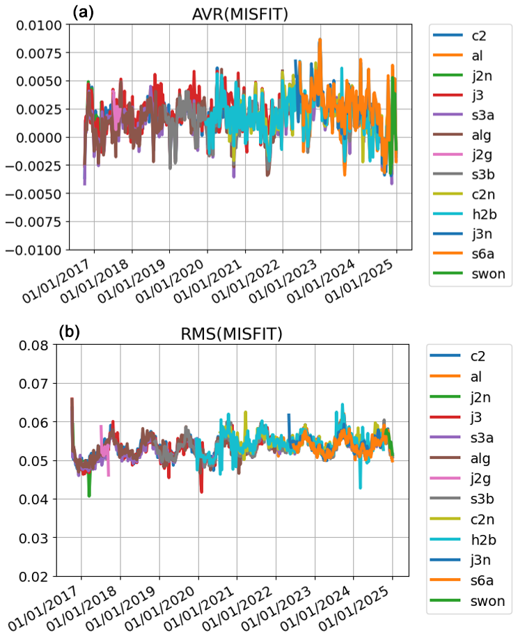
Figure 6Temporal evolution of the global mean SLA innovation (observation − background model first trajectory) (a) and rms of this misfit (b) for the different altimeter data sets assimilated in GLO12v4: c2 (Cryosat-2), al (Alti-Ka), j2n (Jason-2 tandem phase), j3 (Jason-3), s3a (Sentinel 3a), alg (Alti-Ka geodetic phase), j2g (Jason-2 geodetic phase), s3b (Sentinel 3b), c2n (Cryosat-2), h2b (Hy 2b), j3n (Jason-3 tandem phase), s6a (sentinel 6a), and swon (SWOT nadir). Units are metres.
Operational oceanography requirements (three altimeters in addition to a reference altimeter mission in optimized orbits) for satellite altimetry were defined almost 20 years ago (e.g. Johannessen et al., 2006). Since then, the ocean analysis and forecasting systems have evolved strongly, and so has our understanding of the impact of altimeter observations on models. A constellation of four altimeters cannot resolve wavelengths below 150–200 km and timescales of 10 to 20 d. As discussed in Jacobs et al. (2021) and Jacobs et al. (2023), observing systems resolve a range of scales that are larger than the scales models represent. Small-scale model features (e.g. small mesoscale and submesoscale eddies and frontal instabilities) are unconstrained and are not in the correct location, leading to a double-penalty effect (Jacobs et al., 2021). As observation resolution increases, the separation between constrained and unconstrained scales should move to smaller scales.
Much higher spatial and temporal resolutions are needed in the post-2030 period due to the increase in global and regional model resolutions. Beyond 2028, the resolution of Mercator Ocean and Copernicus Marine models is expected to increase by a factor of 3 (e.g. global 1/36°, regional 1/108°). The resolution of current altimeter products is not able to constrain the smallest scales of such high-resolution models. This limitation is emphasized in coastal regions, where the combined effects of the mesoscale, wind, bathymetry, and tides can generate very complex small-scale and high-frequency effects.
The primary focus of an altimeter constellation for operational oceanography should be the observation of ocean dynamics from large scales to the mesoscale as well as the enhancement of the representation of the coastal ocean. The objective proposed for the Copernicus Marine Service (MOi, 2024) would be to resolve wavelengths larger than 50 km every 5 d. Model simulations and in situ data indicate that the scale where balanced and unbalanced motions have the same influence on sea level generally ranges from 30 to 80 km, with seasonal and geographical variability (e.g. Qiu et al., 2018). Given their spatial and temporal scales, these motions are unlikely to be assimilated and propagated into ocean models. To that extent, it is relevant to limit the main requirement to wavelengths of 50 km and 5 d. This limit is already quite challenging but credible from an implementation point of view and consistent with the effective resolution of global and regional models (5 to 10 times larger than the model grid; see Soufflet et al., 2016). The coverage and revisit requirements can be guaranteed with several swath altimeters and an altimeter nadir constellation.
The development of swath altimetry demonstrated with the SWOT mission opens up very promising perspectives with regard to improving our ability to monitor and forecast smaller spatial and temporal scales (e.g. D'Addezio et al., 2019; Tchonang et al., 2021). Through a series of OSSEs, Tchonang et al. (2021) demonstrated that SWOT data could be readily assimilated into a global high-resolution (1/12°) analysis and forecasting system, with a positive impact everywhere and very good performance. Adding SWOT observations to those of three nadir altimeters globally reduced the variance in sea level and surface velocity analyses and forecasts by about 30 % and 20 %, respectively. Assimilation of real SWOT data into the Mercator Ocean global 1/12° model shows promising initial results (Benkiran al., 2025). Compared to results from three nadir altimeters, the addition of SWOT improves the analyses and forecasts by 15 % to 20 %. Future improvements in the data assimilation system (model and observation error characterization, scale separation) should lead to better results. The main limitation of SWOT is, however, related to its 21 d repeat period. In the long run, flying a constellation of several swath altimeters and nadir altimeters would thus be highly beneficial with regard to further improving performance, particularly for the small spatial and temporal scales (e.g. Benkiran et al., 2021, 2024).
Prospects for the joint development of satellite altimetry and operational oceanography for the next decade look promising. The altimeter constellation will be expanded (e.g. CRISTAL, S3C and S3D, S6B and S6C, S6 NG, S3NG, and HY2) (see Fig. 1). The continuation of the reference mission with S6B, S6C, and S6 NG is essential to ensure the homogenization of the constellation and the monitoring of climate signals. Polar regions will be better observed thanks to the CRISTAL missions. From 2032, the S3NG swath altimetry two-satellite constellation will play a major role in constraining the future high-resolution ocean prediction systems.
DUACS and Copernicus Marine Sea Level TAC altimeter products will continue to be improved (see Sect. 2) to optimize their use and impact for operational oceanography: new geophysical corrections (e.g. barotropic and internal tides), better resolution, improved retracking and filtering or noise reduction approaches, improved quality for coastal areas, new products in sea ice regions, and reduced timeliness for data delivery (e.g. <3 h). Developments to improve the quality and resolution of MDTs from global to coastal scales will be carried out.
Ocean prediction systems will evolve from global to coastal scales, with resolution ranging from a few kilometres at the global scale to hundreds of metres at coastal scales, with improved data assimilation schemes, inclusion of new processes, improved coupling (wave–atmosphere), the development of ensemble approaches, and increased use of artificial intelligence (AI). AI is a rapidly evolving field and has major potential for ocean and sea ice forecasting and for improving analysis and forecasting systems (e.g. model emulation, subgrid-scale parameterization, calibration, and bias correction) (e.g. Heimbach et al., 2024). By providing dynamic and interactive cloud-based platforms to model and predict the ocean, explore various scenarios, and assess the impacts on making informed decisions, ocean digital twins are also transformative technologies that will offer new perspectives for the development of operational oceanography.
As far as Copernicus Marine Service or MOi systems are concerned, an ensemble-based analysis and forecasting global system at 1/4° (with 1/12° nested domains using the AGRIF (adaptive grid refinement in Fortran) tool in high-eddy-energy regions) to complement the deterministic system at 1/12° will be put into operation in the coming years. This system will include tidal and atmospheric pressure forcings and will provide uncertainty estimates for the higher-resolution deterministic system and longer-term forecasts up to 28 d. In parallel, the 1/12° prediction system will benefit from an explicit scale separation in the data assimilation scheme to better exploit the observational information available for all scales. A global AI-based forecast system (El Aouni et al., 2024) will also be put into operation. In the long run (post-2028), a higher-resolution global system at 1/36° with improved numerical schemes and parameterizations should be put into operation. One of the priorities will be to introduce new wave–ocean and atmospheric boundary layer (ABL) couplings. The northeastern Atlantic model will include zooms at 1/108° to better represent dynamics in coastal areas.
The evolution of ocean prediction systems depends on the implementation of an adequate ocean observing system. While satellite altimetry has played and will continue to play a prominent role in ocean prediction, improving the altimeter constellation as discussed in Sect. 4 is obviously not sufficient. It is imperative to enhance the integrated satellite and in situ observing system as a whole to ensure that ocean prediction capabilities evolve to best meet societal needs.
No data sets were used in this article.
PYLT led the study and wrote and structured the paper. GD wrote Sect. 2.1. MIP wrote Sect. 2.2. JML contributed to Sect. 2.4 and prepared Table 2. All of the other authors provided comments on and corrections to an initial version of the paper.
The contact author has declared that none of the authors has any competing interests.
Publisher's note: Copernicus Publications remains neutral with regard to jurisdictional claims made in the text, published maps, institutional affiliations, or any other geographical representation in this paper. While Copernicus Publications makes every effort to include appropriate place names, the final responsibility lies with the authors.
This article is part of the special issue “Ocean Science Jubilee: reviews and perspectives”. It is not associated with a conference.
The Copernicus Marine Service is implemented by Mercator Ocean International through a contributing agreement with the European Commission. The long-term support of CNES in the development of DUACS and its links with Mercator Ocean International forecasting systems are greatly acknowledged.
This paper was edited by Karen J. Heywood and reviewed by Sarah Gille and one anonymous referee.
Ablain, M., Cazenave, A., Valladeau, G., and Guinehut, S.: A new assessment of the error budget of global mean sea level rate estimated by satellite altimetry over 1993–2008, Ocean Sci., 5, 193–201, https://doi.org/10.5194/os-5-193-2009, 2009.
Ablain, M., Jugier, R., Zawadki, L., and Taburet, N.: The TOPEX-A Drift and Impacts on GMSL Time Series; Ocean Surface Topography Science Team meeting, https://meetings.aviso.altimetry.fr/fileadmin/user_upload/tx_ausyclsseminar/files/Poster_OSTST17_GMSL_Drift_TOPEX-A.pdf (last access: 10 July 2025), 2017.
Ablain, M., Meyssignac, B., Zawadzki, L., Jugier, R., Ribes, A., Spada, G., Benveniste, J., Cazenave, A., and Picot, N.: Uncertainty in satellite estimates of global mean sea-level changes, trend and acceleration, Earth Syst. Sci. Data, 11, 1189–1202, https://doi.org/10.5194/essd-11-1189-2019, 2019.
Auger, M., Prandi, P., and Sallée, J. B.: Southern Ocean sea level anomaly in the sea ice-covered sector from multimission satellite observations, Sci. Data, 9., 70, https://doi.org/10.1038/s41597-022-01166-z, 2022.
Aviso+: Timeline of modern radar altimetry missions, version 03/2024, https://doi.org/10.24400/527896/A02-2022.001, 2022.
Ballarotta, M., Ubelmann, C., Pujol, M. I., Taburet, G., Fournier, F., Legeais, J. F., Faugère, Y., Delepoulle, A., Chelton, D., Dibarboure, G., and Picot, N.: On the resolutions of ocean altimetry maps, Ocean Sci., 15, 1091–1109, https://doi.org/10.5194/os-15-1091-2019, 2019.
Ballarotta, M., Ubelmann, C., Veillard, P., Prandi, P., Etienne, H., Mulet, S., Faugère, Y., Dibarboure, G., Morrow, R., and Picot, N.: Improved global sea surface height and current maps from remote sensing and in situ observations, Earth Syst. Sci. Data, 15, 295–315, https://doi.org/10.5194/essd-15-295-2023, 2023.
Ballarotta, M., Ubelmann, C., Bellemin-Laponnaz, V., Le Guillou, F., Meda, G., Anadon, C., Laloue, A., Delepoulle, A., Faugère, Y., Pujol, M.-I., Fablet, R., and Dibarboure, G.: Integrating wide-swath altimetry data into Level-4 multi-mission maps, Ocean Sci., 21, 63–80, https://doi.org/10.5194/os-21-63-2025, 2025a.
Ballarotta, M., Pujol, M.-I., and SL-TAC team: Quality Information Document for Sea Level TAC – DUACS products, Issue 13.0, https://documentation.marine.copernicus.eu/QUID/CMEMS-SL-QUID-008-032-068.pdf (last access: 8 July 2025), 2025b.
Bell, M. J., Lefebvre, M., Le Traon, P. Y., Smith, N., and Wilmer-Becker, K.: The Global Ocean Data Assimilation Experiment, Oceanography, 22, 14–21, 2009.
Bell, M. J., Schiller, A., Le Traon, P. Y., Smith, N. R., Dombrowsky, E., and Wilmer-Becker, K.: An introduction to GODAE OceanView, J. Operat. Oceanogr., 8, s2–s11, https://doi.org/10.1080/1755876X.2015.1022041, 2015.
Benkiran, M. and Greiner, E.: Impact of the Incremental Analysis Updates on a Real-Time System of the North Atlantic Ocean, J. Atmos. Ocean. Tech., 25, 2055–2073, 2008.
Benkiran, M., Ruggiero, G., Greiner, E., Le Traon, P. Y., Remy, E., Lellouche, J. M., Bourdallé-Badie, R., Drillet Y., and Tchonang, B.: Assessing the Impact of the Assimilation of SWOT Observations in a Global High-Resolution Analysis and Forecasting System Part 1: Methods, Front. Mar. Sci., 8, 691955, https://doi.org/10.3389/fmars.2021.691955, 2021.
Benkiran, M., Le Traon, P. Y., Remy, E., and Drillet, Y.: Impact of two high resolution altimetry mission concepts on ocean forecasting, Front. Mar. Sci., 11, 1465065, https://doi.org/10.3389/fmars.2024.1465065, 2024.
Benkiran, M., Fouchet, E., Le Traon, P. Y., Remy, E., and Drillet, Y.: SWOT and swath altimetry: a breakthrough for global ocean prediction, Geophys. Res. Lett., in review, 2025.
Birol, F., Bignalet-Cazalet, F., Cancet, M., Daguze, J.-A., Fkaier, W., Fouchet, E., Léger, F., Maraldi, C., Niño, F., Pujol, M.-I., and Tran, N.: Understanding uncertainties in the satellite altimeter measurement of coastal sea level: insights from a round-robin analysis, Ocean Sci., 21, 133–150, https://doi.org/10.5194/os-21-133-2025, 2025.
Brasseur, P. and Verron, J.: The SEEK filter method for data assimilation in oceanography: a synthesis, J. Ocean Dynam., 56, 650– 661, https://doi.org/10.1007/s10236-006-0080-3, 2006.
Caballero, A., Mulet, S., Ayoub, N., Manso-Narvarte, I., Davila, X., Boone, C., Toublanc, F., and Rubio, A.: Integration of HF Radar Observations for an Enhanced Coastal Mean Dynamic Topography, Front. Mar. Sci., 7, 588713, https://doi.org/10.3389/fmars.2020.588713, 2020.
Cadier, E., Courcol, B., Prandi, P., Quet, V., Moreau, T., Maraldi, C., Bignalet-Cazalet, F., Dinardo, S., Martin-Puig, C., and Donlon, C.: Assessment of Sentinel-6MF low resolution numerical retracker over ocean: Continuity on reference orbit and improvements, Adv. Space Rese., 75, 30–52, https://doi.org/10.1016/j.asr.2024.11.045, 2025.
Carrere, L., Lyard, F., Allain, D., Cancet, M., Picot, N., Guillot, A., Faugère, Y., Dupuy, S., and Baghi, R.: Final version of the FES2014 global ocean tidal model, which includes a new loading tide solution, OSTST, La Rochelle, France, https://ostst.aviso.altimetry.fr/fileadmin/user_upload/tx_ausyclsseminar/files/Poster_FES2014b_OSTST_2016.pdf (last access: 10 July 2025), 2016.
Carrere, L., Lyard, F., Cancet, M., Allain, D., Dabat, M.-L., Fouchet, E., Sahuc, E., Faugere, Y., Dibarboure, G., and Picot, N.: A new barotropic model for global ocean : FES2022. OSTST, https://ostst.aviso.altimetry.fr/programs/abstracts-details.html?tx_ausyclsseminar_pi2%5bobjAbstracte%5d=3287&cHash=X (last access: 10 July 2025), 2023.
Chassignet, E. P., Pascual, A., Tintoré, J., and Verron, J. (Eds.): New Frontiers in Operational Oceanography, GODAE OceanView, 815 pp., https://doi.org/10.17125/gov2018, 2018.
Ciliberti, S. A., Jansen, E., Coppini, G., Peneva, E., Azevedo, D., Causio, S., Stefanizzi, L., Creti', S., Lecci, R., Lima, L., Ilicak, M., Pinardi, N., and Palazov, A.: The Black Sea Physics Analysis and Forecasting System within the Framework of the Copernicus Marine Service, J. Mar. Sci. Eng., 10, 48, https://doi.org/10.3390/jmse10010048, 2022.
Cooper, M. and Haines, K.: Data assimilation with water property conservation, J. Geophys. Res., 101, 1059–1077, 1996.
D'Addezio, J. M., Smith, S., Jacobs, G. A., Helber, R. W., Rowley, C., Souopgui, I., and Carrier, M. J.: Quantifying wavelengths constrained by simulated SWOT observations in a submesoscale resolving ocean analysis/forecasting system, Ocean Model., 135, 40–55, https://doi.org/10.1016/j.ocemod.2019.02.001, 2019.
Dibarboure, G. and Lambin, J.: Monitoring the ocean surface topography virtual constellation: Lessons learned from the contribution of SARAL/AltiKa, Mar. Geod., 38, 684–703, 2015.
Dibarboure, G. and Morrow, R.: Value of the Jason-1 geodetic phase to study rapid oceanic changes and importance for defining a Jason-2 geodetic orbit, J. Atmos. Ocean. Tech., 33, 1913–1930, 2016.
Dibarboure, G., Pujol, M. I., Pascual, A., and Bronner, E. : Using short scale content of OGDR data improve the Near Real Time products of SSALTO/DUACS, OSTST 2009, https://www.aviso.altimetry.fr/fileadmin/documents/OSTST/2009/oral/Dibarboure.pdf (last access: 20 January 2025), 2009.
Dibarboure, G., Pujol, M. I., Briol, F., Le Traon, P. Y., Larnicol, G., Picot, N., Mertz, F., and Ablain, M.: Jason-2 in DUACS: Updated System Description, First Tandem Results and Impact on Processing and Products, Mar. Geod., 34, 214–241, 2011.
Dibarboure, G., Anadon, C., Briol, F., Cadier, E., Chevrier, R., Delepoulle, A., Faugère, Y., Laloue, A., Morrow, R., Picot, N., Prandi, P., Pujol, M.-I., Raynal, M., Tréboutte, A., and Ubelmann, C.: Blending 2D topography images from the Surface Water and Ocean Topography (SWOT) mission into the altimeter constellation with the Level-3 multi-mission Data Unification and Altimeter Combination System (UACS), Ocean Sci., 21, 283–323, https://doi.org/10.5194/os-21-283-2025, 2025.
Drake, P., Edwards, C. A., Arango, H. G., Wilkin, J., TajalliBakhsh, T., Powell, B., and Moore, A. M.: Forecast Sensitivity-based Observation Impact (FSOI) in an analysis–forecast system of the California Current Circulation, Ocean Model., 182, 102159, https://doi.org/10.1016/j.ocemod.2022.102159, 2023.
Drévillon, M., Bourdallé-Badie, R., Derval, C., Lellouche, J. M., Rémy, E., Tranchant, B., Benkiran, M., Grenier, E., Guinehut, S., Verbrugge, N., Garric, G., Testut, C. E., Laborie, M., Nouel, L., Bahurel, P., Bricaud, C., Crosnier, L., Dombrowsky, E., Durand, E., Ferry, N., Hernandez, F., Le Galloudec, O., Messal, F., and Parent, L.: The GODAE/Mercator-Ocean global ocean forecasting system: results, applications and prospects, J. Oper. Oceanogr., 1, 51–57, https://doi.org/10.1080/1755876X.2008.11020095, 2008.
Ducet, N., Le Traon, P. Y., and Reverdin, G.: Global high-resolution mapping of ocean circulation from the combination of T/P and ERS-1/2, J. Geophys. Res., 105, 19477–19498, 2000.
El Aouni, A., Gaudel, Q., Regnier, C., Van Gennip, S., Drevillon, M., Drillet, Y., and Lellouche, J. M.: GLONET: Mercator's End-to-End Neural Forecasting System, arXiv [preprint], https://doi.org/10.48550/arXiv.2412.05454, 2024.
Faugère, Y., Taburet, G., Ballarotta, M., Pujol, I., Legeais, J. F., Maillard, G., Durand, C., Dagneau, Q., Lievin, M., Sanchez Roman, A., and Dibarboure, G.: DUACS DT2021: 28 years of reprocessed sea level altimetry products, EGU General Assembly 2022, Vienna, Austria, 23–27 May 2022, EGU22-7479, https://doi.org/10.5194/egusphere-egu22-7479, 2022.
Fennel, K., Gehlen, M., Brasseur, P., Brown, C. W., Ciavatta, S., Cossarini, G., Crise, A., Edwards, C. A., Ford, D., Friedrichs, M. A. M., Gregoire, M., Jones, E., Kim, H.-C., Lamouroux, J., Murtugudde, R., Perruche, C., and the GODAE OceanView Marine Ecosystem Analysis and Prediction Task Team: Advancing Marine Biogeochemical and Ecosystem Reanalyses and Forecasts as Tools for Monitoring and Managing Ecosystem Health, Front. Mar. Sci., 6, 89, https://doi.org/10.3389/fmars.2019.00089, 2019.
Ferry, N., Remy, E., Brasseur, P., and Maes, C.: The Mercator Ocean operational analysis/forecast system: assessment and validation of a 11-year reanalysis, J. Mar. Syst., 65, 540–560, https://doi.org/10.1016/j.jmarsys.2005.08.004, 2007.
Flechtner, F., Sneeuw, N., and Schuh, W. D. (Eds.): Observation of the System Earth from Space – CHAMP, GRACE, GOCE and future missions, in: Advanced Technologies in Earth Sciences, Springer, Berlin, Heidelberg, https://doi.org/10.1007/978-3-642-32135-1, 2014.
Francis, P., Jithin, A., Effy, J., Chatterjee, A., Chakraborty, K., Paul, A., Balaji, B., Shenoi, S., Biswamoy, P., Mukherjee, A., Singh, P., Deepsankar, B., Reddy, S., Vinayachandran, P., Kumar, M., Bhaskar, T., Ravichandran, M., Unnikrishnan, A., Shankar, D., Prakash, A., Aparna, S., Harikumar, R., Kaviyazhahu, K., Suprit, K., Shesu, R., Kumar, N., Rao, N., Annapurnaiah, K., Venkatesan, R., Rao, A., Rajagopal, E., Prasad, V., Gupta, M., Nair, T., Rao, E., and Satyanarayana, B.: High-Resolution Operational Ocean Forecast and Reanalysis System for the Indian Ocean, B. Am. Meteorol. Soc., 101, E1340–E1356, https://doi.org/10.1175/BAMS-D-19-0083.1, 2020.
Fu, L. L. and Cazenave, A.: Satellite Altimetry and Earth Sciences. A Handbook of Techniques and Applications. Preface, in: International Geophysics, Vol. 69, edited by: Fu, L.-L. and Cazenave, A., Academic Press, https://doi.org/10.1016/S0074-6142(01)80145-5, 2001.
Fu, L.-L., Pavelsky, T., Cretaux, J.-F., Morrow, R., Farrar, J. T., Vaze, P., Sengenes, P., Vinogradova-Shiffer, N., Sylvestre-Baron, A., Picot, N., and Dibarboure, G.: The Surface Water and Ocean Topography Mission: A breakthrough in radar remote sensing of the ocean and land surface water, Geophys. Res. Lett., 51, e2023GL107652, https://doi.org/10.1029/2023GL107652, 2024.
Fujii, Y., Rémy, E., Zuo, H., Oke, P., Halliwell, G., Gasparin, F., Benkiran, M., Loose, N., Cummings, J., Xie, J., Xue, Y., Masuda, S., Smith, G. C., Balmaseda, M., Germineaud, C., Lea, D. J., Larnicol, G., Bertino, L., Bonaduce, A., Brasseur, P., Donlon, C., Heimbach, P., Kim, Y., Kourafalou, V., Le Traon, P. Y., Martin, M., Paturi, S., Tranchant, B., and Usui, N.: Observing System Evaluation Based on Ocean Data Assimilation and Prediction Systems: On-Going Challenges and a Future Vision for Designing and Supporting Ocean Observational Networks, Front. Mar. Sci., 6, 417, https://doi.org/10.3389/fmars.2019.00417, 2019.
Gasparin, F., Cravatte, S., Greiner, E., Perruche, C., Hamon, M., Van Gennip, S., and Lellouche, J. M.: Excessive Productivity and Heat Content in Tropical Pacific Analyses: Disentangling the Effects of In Situ and Altimetry Assimilation, Ocean Model., 160, 101768, https://doi.org/10.1016/j.ocemod.2021.101768, 2021.
Gasparin, F., Lellouche, J. M., Cravatte, S., Ruggiero, G., Rohith, B., Le Traon, P. Y., and Rémy E.: On the control of spatial and temporal oceanic scales by existing and future observing systems: An observing system simulation experiment approach, Front. Mar. Sci., 10, 1021650, https://doi.org/10.3389/fmars.2023.1021650, 2023.
Guérou, A., Meyssignac, B., Prandi, P., Ablain, M., Ribes, A., and Bignalet-Cazalet, F.: Current observed global mean sea level rise and acceleration estimated from satellite altimetry and the associated measurement uncertainty, Ocean Sci., 19, 431–451, https://doi.org/10.5194/os-19-431-2023, 2023.
Hamon, M., Greiner, E., Le Traon, P. Y., and Remy, E.: Impact of multiple altimeter data and mean dynamic topography in a global analysis and forecasting system, J. Atmos. Ocean. Tech., 36, 1255–1266, https://doi.org/10.1175/JTECH-D-18-0236.1, 2019.
Heimbach, P., Fukumori, I., Hill, C. N., Ponte, R. M., Stammer, D., Wunsch, C., Campin, J. M., Cornuelle, B., Fenty, I., Forget, G., Köhl, A., Mazloff, M., Menemenlis, D., Nguyen, A. T., Piecuch, C., Trossman, D., Verdy, A., Wang, O., and Zhang, H.: Putting It All Together: Adding Value to the Global Ocean and Climate Observing Systems with Complete Self-Consistent Ocean State and Parameter Estimates, Front. Mar. Sci., 6, 55, https://doi.org/10.3389/fmars.2019.00055, 2019.
Heimbach, P., O'Donncha, F., Garcia-Valdecasas, J. M., Arnaud, A., and Wan, L.: Crafting the Future: Machine Learning for Ocean Forecasting, State Planet Discuss. [preprint], https://doi.org/10.5194/sp-2024-18, in review, 2024.
Hernandez, F. and Schaeffer, P.: Altimetric Mean Sea Surfaces and Gravity Anomaly Maps Inter-Comparisons; AVISO Tech. Rep. AVI-NT-011-5242-CLS, Centre Nationale d'Etudes Spatiales, Toulouse, France, 2002.
Hirose, N., Usui, N., Sakamoto, K., Tsujino, H., Yamanaka, G., Nakano, H., Urakawa, S., Toyoda, T., Fujii, Y., and Kohno, N.: Development of a new operational system for monitoring and forecasting coastal and open-ocean states around Japan, Ocean Dynam., 69, 1333–1357, https://doi.org/10.1007/s10236-019-01306-x, 2019.
International Altimetry Team: Altimetry for the future: Building on 25 years of progress, Adv. Space Res., 68, 319–363, 2021.
Jacobs, G., D'Addezio, J. M., Ngodock, H., and Souopgui, I.: Observation and model resolution implications to ocean prediction, Ocean Model., 159, 101760, https://doi.org/10.1016/j.ocemod.2021.101760, 2021.
Jacobs, G., D'Addezio, J. M., Bartels, B., DeHaan, C., Barron, C., Carrier, M., Shcherbina, A., and Dever, M.: Adapting constrained scales to observation resolution in ocean forecasts, Ocean Model., 186, 102252, https://doi.org/10.1016/j.ocemod.2023.102252, 2023.
Johannessen, J. A., Le Traon, P. Y., Robinson, I., Nittis, K., Bell, M. J., Pinardi, N., and Bahurel, P.: Marine Environment and Security for the European Area, B. Am. Meteorol. Soc., 87, 1081–1090, https://doi.org/10.1175/BAMS-87-8-1081, 2006.
Jousset, S., Mulet, S., Greiner, E., Wilkin, J., Vidar, L., Dibarboure, G., and Picot, N.: New Global Mean Dynamic Topography CNES-CLS-22 Combining Drifters, Hydrological Profiles and High Frequency Radar Data, Authorea Preprints, https://essopenarchive.org/doi/pdf/10.22541/essoar.170158328.85804859 (last access: September 2024), 2023.
Kocha, C., Lievin, M., Philipps, S., Pageot, Y., Rubin, C., Quet, V., Dibarboure, G., Nogueira Loddo, C., Denis, I., and Guinle, T.: 30 years of sea level multi-mission reprocessed to improve climate and mesoscale satellite data record, in: 30 Years of Progress in Radar Altimetry Symposium, Montpellier, France, https://az659834.vo.msecnd.net/eventsairwesteuprod/production-nikal-public/db505ebc90764a88911bb465efa7bb09 (last access: 27 December 2024), 2024.
Kocha, C., Lievin, M., Pageot, Y., Rubin, C., Philipps, S., Pujol, M. I., Dibarboure G., Denis, I., Nogueira Loddo, C., and Guinle, T.: 30 years of sea level multi-mission satellite dataset reprocessed to improve climate and mesoscale, in preparation, 2025.
Kvas, A., Brockmann, J. M., Krauss, S., Schubert, T., Gruber, T., Meyer, U., Mayer-Gürr, T., Schuh, W. D., Jäggi, A., and Pail, R.: GOCO06s – a Satellite-Only Global Gravity Field Model, Earth Syst. Sci. Data, 13, 99–118, https://doi.org/10.5194/essd-13-99-2021, 2021.
Laloue, A., Schaeffer, P., Pujol, M.-I., Veillard, P., Andersen, O., Sandwell, D., Delepoulle, A., Dibarboure, G., and Faugere, Y.: Merging recent Mean Sea Surface into a 2023 Hybrid model (from Scripps, DTU, CLS and CNES), Earth Space Sci., 12, e2024EA003836, https://doi.org/10.1029/2024EA003836, 2025.
Lellouche, J.-M., Le Galloudec, O., Drévillon, M., Régnier, C., Greiner, E., Garric, G., Ferry, N., Desportes, C., Testut, C.-E., Bricaud, C., Bourdallé-Badie, R., Tranchant, B., Benkiran, M., Drillet, Y., Daudin, A., and De Nicola, C.: Evaluation of global monitoring and forecasting systems at Mercator Océan, Ocean Sci., 9, 57–81, https://doi.org/10.5194/os-9-57-2013, 2013.
Lellouche, J.M., Greiner, E., Le Galloudec, O., Garric, G., Regnier, C., Drevillon, M., Benkiran, M., Testut, C.-E., Bourdalle-Badie, R., Gasparin, F., Hernandez, O., Levier, B., Drillet, Y., Remy, E., and Le Traon, P.-Y.: Recent updates to the Copernicus Marine Service global ocean monitoring and forecasting real-time 1/12° high-resolution system, Ocean Sci., 14, 1093–1126, https://doi.org/10.5194/os-14-1093-2018, 2018.
Lellouche, J. M., Greiner, E., Bourdallé-Badie, R., Garric, G., Melet, A., Drevillon, M., Bricaud, C., Hamon, M., Le Galloudec, O., Regnier, C., Candela, T., Testut, C. E., Gasparin, F., Ruggiero, G., Benkiran, M., Drillet, Y., and Le Traon, P. Y.: The Copernicus Global 1/12° Oceanic and Sea Ice GLORYS12 Reanalysis, Front. Earth Sci., 9, 698876., https://doi.org/10.3389/feart.2021.698876, 2021.
Lellouche, J. M., Greiner, E., Ruggiero, G., Bourdallé-Badie, R., Testut, C. E., Le Galloudec, O., Benkiran, M., and Garric, G.: Evolution of the Copernicus Marine Service global ocean analysis and forecasting high-resolution system: potential benefit for a wide range of users, Proceeding Eurogoos, 242–251, http://hdl.handle.net/10793/1883 (last access: 10 July 2025), 2023.
Lemoine, F. G., Kenyon, S. C., Factor, J. K., Trimmer, R. G., Pavlis, N. K., Chinn, D. S., Cox, C. M., Klosko, S. M., Luthcke, S. B., Torrence, M. H., Wang, Y. M., Williamson, R. G., Pavlis, E. C., Rapp, R. H., and Olson, T. R.: The development of the joint NASA GSFC and the National Imagery and Mapping Agency (NIMA) Geopotential Model EGM96, Rep. NASA/TP-1998-206861, NASA Goddard Space Flight Cent., Greenbelt, MD, 1998.
Le Traon, P. Y.: From satellite altimetry to Argo and operational oceanography: three revolutions in oceanography, Ocean Sci., 9, 901–915, https://doi.org/10.5194/os-9-901-2013, 2013.
Le Traon, P. Y., Rienecker, M., Smith, N., Bahurel, P., Bell, M., Hurlburt, H., and Dandin, P.: Operational oceanography and prediction – a GODAE perspective, in: Observing the Oceans in the 21st Century, edited by: Koblinsky, C. J. and Smith, N. R., ARCHIMER, http://archimer.ifremer.fr/doc/00090/20096/ (last access: 10 July 2025), 2001.
Le Traon, P. Y., Dibarboure, G., Jacobs, G., Martin, M., Remy, E., and Schiller, A.: Use of satellite altimetry for operational oceanography in Satellite Altimetry Over Oceans and Land Surfaces, CRC Press, 581–608, https://doi.org/10.1201/9781315151779-18 2017.
Le Traon, P. Y., Reppucci, A., Alvarez Fanjul, E., et al.: From Observation to Information and Users: The Copernicus Marine Service Perspective, Front. Mar. Sci., 6, 234, https://doi.org/10.3389/fmars.2019.00234, 2019.
Le Traon, P. Y., Abadie, V., Ali, A., et al.: The Copernicus Marine Service from 2015 to 2021: six years of achievements, Mercator Ocean J., 57, 220 pp., https://doi.org/10.48670/moi-cafr-n813, 2021.
Mercator Ocean International (MOi): Copernicus Marine Service requirements for the Evolution of the Copernicus Satellite Component – V2 April 2024, Copernicus Marine Space Requirements, https://marine.copernicus.eu/sites/default/files/media/pdf/2024-06/Copernicus_Marine_Space_Requirements_2024.pdf (last access: 10 July 2025), 2024.
Metzger, E. J., Smedstad, O. M., Thoppil, P. G., Hurlburt, H. E., Cummings, J. A., Wallcraft, A. J., Zamudio, L., Franklin, D. S., Posey, P. G., Phelps, M. W., Hogan, P. J., Bub, F. L., and DeHaan, C. J.: US Navy operational global ocean and Arctic ice prediction systems, Oceanography, 27, 32–43, https://doi.org/10.5670/oceanog.2014.66, 2014.
Moreau, T., Cadier, E., Boy, F., Aublanc, J., Rieu, P., Raynal, M., Labroue, S., Thibaut, P., Dibarboure, G., Picot, N., Phalippou, L., Demeestere, F., Borde, F., and Mavrocordatos, C.: High-performance altimeter Doppler processing for measuring sea level height under varying sea state conditions, Adv. Space Res., 67, 1870–1886, https://doi.org/10.1016/j.asr.2020.12.038, 2021.
Morrow, R., Fu, L. L., Ardhuin, F., Benkiran, M., Chapron, B., Cosme, E., d'Ovidio, F., Farrar, J. T., Gille, S. T., Lapeyre, G., Le Traon, P. Y., Pascual, A., Ponte, A., Qiu, B., Rascle, N., Ubelmann, C., Wang, J., and Zaron, E. D.: Global Observations of Fine-Scale Ocean Surface Topography With the Surface Water and Ocean Topography (SWOT) Mission, Front. Mar. Sci., 6, 232, https://doi.org/10.3389/fmars.2019.00232, 2019.
Mulet, S., Rio, M. H., Etienne, H., Artana, C., Cancet, M., Dibarboure, G., Feng, H., Husson, R., Picot, N., Provost, C., and Strub, P. T.: The new CNES-CLS18 global mean dynamic topography, Ocean Sci., 17, 789–808, https://doi.org/10.5194/os-17-789-2021, 2021.
Pinardi, N., Alvarez Fanjul, E., Kouroufalou, V., Tintoré, J., Heslop, E., Coppini, G., Federico I., Bahurel, P., Valentini, A., and Drillet, Y.: Assessing ocean prediction capabilities for sustainable development, State of the Ocean Report, IOC-UNESCO, Paris, 45–51, https://doi.org/10.25607/4wbg-d349, 2024.
Prandi, P., Meyssignac, B., Ablain, M., Spada, G., Ribes, A., and Benveniste, J.: Local sea level trends, accelerations and uncertainties over 1993–2019, Sci. Data, 8, 1, https://doi.org/10.1038/s41597-020-00786-7, 2021a.
Prandi, P., Poisson, J.-C., Faugère, Y., Guillot, A., and Dibarboure, G.: Arctic sea surface height maps from multi-altimeter combination, Earth Syst. Sci. Data, 13, 5469–5482, https://doi.org/10.5194/essd-13-5469-2021, 2021b.
Pujol, M. I., Faugère, Y., Taburet, G., Dupuy, S., Pelloquin, C., Ablain, M., and Picot, N.: DUACS DT2014: the new multi-mission altimeter data set reprocessed over 20 years, Ocean Sci., 12, 1067–1090, https://doi.org/10.5194/os-12-1067-2016, 2016.
Pujol, M. I., Schaeffer, P., Faugère, Y., Raynal, M., Dibarboure, G., and Picot, N.: Gauging the Improvement of Recent Mean Sea Surface Models: A New Approach for Identifying and Quantifying Their Errors, J. Geophys. Res.-Oceans, 123, 5889–5911, https://doi.org/10.1029/2017JC013503, 2018.
Pujol, M. I., Dupuy, S., Vergara, O., Sánchez Román, A., Faugère, Y., Prandi, P., Dabat, M.L., Dagneux, Q., Lievin, M., Cadier, E., Dibarboure, G., and Picot, N.: Refining the Resolution of DUACS Along-Track Level-3 Sea Level Altimetry Products, Remote Sens., 15, 793, https://doi.org/10.3390/rs15030793, 2023.
Pujol, M.-I., Ballarotta, M., Taburet, G., Delepoulle, A., Dupuy, S., Kocha, C., Jenn-Alet, M., Dagneaux, Q., Dibarboure, D., and Faugère, Y.: DUACS DT-2024: the new reprocessing of the sea level anomaly Level-3&4 altimeter products. 30 Years of Progress in Radar Altimetry Symposium, Montpellier, France, https://az659834.vo.msecnd.net/eventsairwesteuprod/production-nikal-public/28e0b1c170034be19bebd6fefa5a383d (last access: 27 December 2024), 2024a.
Pujol, M.-I., Ballarotta, M.,Taburet, G., Delepoulle, A., Dupuy, S., Vergara, O., Veillard, P., Treboutte, A., Dibarboure, G., and Faugère, Y.: 30 years of altimetry Sea Level L3/L4 products record: major improvements in recent decades. 30 Years of Progress in Radar Altimetry Symposium, Montpellier, France, https://az659834.vo.msecnd.net/eventsairwesteuprod/production-nikal-public/e9c9f65e5cca420ebfa7591efc20380f (last access: 27 December 2024), 2024b.
Qiu, B., Chen, S., Klein, P., Wang, J., Torres, H., Fu, L. L., and Menemenlis, D.: Seasonality in Transition Scale from Balanced to Unbalanced Motions in the World Ocean, J. Phys. Oceanogr., 48, 591–605, https://doi.org/10.1175/JPO-D-17-0169.1, 2018.
Raynal, M., Labroue, S., Moreau, T., Boy, F., and Picot, N.: From conventional to Delay Doppler altimetry: A demonstration of continuity and improvements with the Cryosat-2 mission, Adv. Space Res., 62, 1564–1575, https://doi.org/10.1016/j.asr.2018.01.006, 2018.
Rio, M.-H. and Hernandez, F.: A mean dynamic topography computed over the world ocean from altimetry, in situ measurements, and a geoid model, J. Geophys. Res., 109, C12032, https://doi.org/10.1029/2003JC002226, 2004.
Rio, M. H., Guinehut, S., and Larnicol, G.: New CNES-CLS09 global mean dynamic topography computed from the combination of GRACE data, altimetry, and in situ measurements, J. Geophys. Res., 116, C07018, https://doi.org/10.1029/2010JC006505, 2011.
Rio, M. H., Mulet, S., and Picot, N.: Beyond GOCE for the ocean circulation estimate: Synergetic use of altimetry, gravimetry, and in situ data provides new insight into geostrophic and Ekman currents. Geophys. Res. Lett., 41, 8918–8925, https://doi.org/10.1002/2014GL061773, 2014.
Roemmich, D., Boebel, O., Desaubies, Y., Freeland, F., Kim, K., King, B., Le Traon, P. Y., Molinari, B., Owens, B., Riser, S., Send, U., Takeuchi, K., and Wijffels, S.: Argo: The Global Array of Profiling Floats, in: Observing the Oceans in the 21st Century, edited by: Koblinsky, C. J. and Smith, N. R., GODAE Project Office, Bureau of Meteorology, 248–258, 2001.
Schaeffer P., Faugere, Y, Legeais J. F., Picot, N., and Bronner, E.: The CNES_CLS11 Global Mean Sea Surface computed from 16 years of satellite altimeter data, Mar. Geod., 35, 3–19, https://doi.org/10.1080/01490419.2012.718231, 2012.
Schaeffer, P., Pujol, M. I., Veillard, P., Faugere, Y., Dagneaux, Q., Dibarboure, G., and Picot, N.: The CNES CLS 2022 Mean Sea Surface: Short Wavelength Improvements from CryoSat-2 and SARAL/AltiKa High-Sampled Altimeter Data, Remote Sens., 15, 2910, https://doi.org/10.3390/rs15112910, 2023.
Schiller, A., Brassington, G. B., Oke, P., Cahill, M., Divakaran, P., Entel, Freeman, J., Griffin, D., Herzfeld, M., Hoeke, R., Huang, X., Jones, E., King, E., Parker, B., Pitman, T., Rosebrock, U., Sweeney, J., Taylor, A., Thatcher, M., Woodham, R., and Zhong, A.: Bluelink ocean forecasting Australia: 15 years of operational ocean service delivery with societal, economic and environmental benefits, J. Oper. Oceanogr., 13, 1–18, https://doi.org/10.1080/1755876X.2019.1685834, 2019.
Smith, N. and Lefebvre, M.: The Global Ocean Data Assimilation Experiment (GODAE), in: Monitoring the oceans in the 2000s: an integrated approach, International Symposium, 15–17 October 1997, Biarritz, 1997.
Soufflet, Y., Marchesiello, P., Lemarié, F., Jouanno, J., Capet, X., Debreu, L., and Benshila, R.: On effective resolution in ocean models, Ocean Model., 98, 36–50, https://doi.org/10.1016/j.ocemod.2015.12.004, 2016.
Taburet, G., Sanchez-Roman, A., Ballarotta, M., Pujol, M. I., Legeais, J. F., Fournier, F., Faugere, Y., and Dibarboure, G.: DUACS DT-2018: 25 years of reprocessed sea level altimeter products, Ocean Sci., 15, 1207–1224, https://doi.org/10.5194/os-15-1207-2019, 2019.
Tchilibou, M., Carrere, L., Lyard, F., Ubelmann, C., Dibarboure, G., Zaron, E. D., and Arbic, B. K.: Internal tides off the Amazon shelf in the western tropical Atlantic: analysis of SWOT Cal/Val mission data, Ocean Sci., 21, 325–342, https://doi.org/10.5194/os-21-325-2025, 2025.
Tchonang, B. C., Benkiran, M., Le Traon, P. Y., van Gennip, S. J., Lellouche, J. M., and Ruggiero, G.: Assessing the Impact of the Assimilation of SWOT Observations in a Global High-Resolution Analysis and Forecasting System – Part 2: Results, Front. Mar. Sci., 8, 687414, https://doi.org/10.3389/fmars.2021.687414, 2021.
Tran, N., Vandemark, D., Zaron, E., Thibaut, P., Dibarboure, G., and Picot, N.: Assessing the effects of sea-state related errors on the precision of high-rate Jason-3 altimeter sea level data, Adv. Space Res., 68, 963–977, https://doi.org/10.1016/j.asr.2019.11.034, 2021.
Ubelmann, C., Dibarboure, G., Gaultier, L., Ponte, A., Ardhuin, F., Ballarotta, M., and Faugère, Y.: Reconstructing ocean surface current combining altimetry and future spaceborne Doppler data, J. Geophys. Res.-Oceans, 126, e2020JC016560, https://doi.org/10.1029/2020JC016560, 2021.
Veillard, P., Prandi, P., Pujol, M. I., Daguzé, J. A., Piras, F., Dibarboure, G., and Faugère, Y.: Arctic and Southern Ocean polar sea level maps and along-tracks from multi-mission satellite altimetry from 2011 to 2021, Front. Mar. Sci., 11, 1419132, https://doi.org/10.3389/fmars.2024.1419132, 2024.
Verrier, S., Le Traon, P. Y., and Remy, E.: Assessing the impact of multiple altimeter missions and Argo in a global eddy-permitting data assimilation system, Ocean Sci., 13, 1077–1092, https://doi.org/10.5194/os-13-1077-2017, 2017.
Verrier, S., Le Traon, P. Y., Remy, E., and Lellouche, J. M.: Assessing the impact of SAR altimetry for global ocean analysis and forecasting, J. Oper. Oceanogr., 11, 82–86, https://doi.org/10.1080/1755876X.2018.1505028, 2018.
Verron, J., Bonnefond, P., Andersen, O., Ardhuin, F., Bergé-Nguyen, M., Bhowmick, S., Blumstein, D., Boy, F., Brodeau, L., Crétaux, J. F., Dabat, M. L., Dibarboure, G., Fleury, S., Garnier, F., Gourdeau, L., Marks, K., Queruel, N., Sandwell, D., Smith, W. H. F., and Zaron, E. D.: The SARAL/AltiKa mission: A step forward to the future of altimetry, Adv. Space Rese., 68, 808–828, https://doi.org/10.1016/j.asr.2020.01.030, 2021.
Vignudelli, S., Kostianoy, A. G., Cipollini, P., and Benveniste, J. (Eds.): Coastal altimetry, Springer Science & Business Media, Berlin, 565 pp., https://doi.org/10.1007/978-3-642-12796-0, 2011.
von Schuckmann, K., Moreira, L., Grégoire, M., Marcos, M., Staneva, J., Brasseur, P., Garric, G., Lionello, P., Karstensen, J., and Neukermans, G. (Eds.): 8th edition of the Copernicus Ocean State Report (OSR8), State Planet, 4-osr8, https://doi.org/10.5194/sp-4-osr8, 2024.
Yu, Y., Sandwell, D. T., and Dibarboure, G.: Abyssal marine tectonics from the SWOT mission, Science, 386, 1251–1256, 2024.
- Abstract
- Introduction
- Development and evolution of satellite altimetry and operational oceanography
- Impact of altimetry on ocean prediction systems
- The development of swath altimetry and its role in ocean prediction
- Prospects for the next decade
- Data availability
- Author contributions
- Competing interests
- Disclaimer
- Special issue statement
- Acknowledgements
- Review statement
- References