the Creative Commons Attribution 4.0 License.
the Creative Commons Attribution 4.0 License.
 | 06 Mar 2026
Tracking marine debris in Northwest Spain: assessing wind influence with a Lagrangian transport model
Martiño Rial-Osorio
Vicente Pérez-Muñuzuri
Sara Cloux
Marine debris is responsible for major problems in our oceans, causing serious environmental degradation, detrimental health effects and economic losses in sectors related to the marine environment. In this work, we examine how plastics released by the Ulla river at the estuary's extreme affect the transport, accumulation, and beaching of floating particles in the Ría de Arousa, an estuary on the northwest coast of the Iberian Peninsula, as a result of wind force. Using Lagrangian simulations of particle tracking under different wind drag coefficients (1 %, 3 % and 5 %), we evaluate the spatial and seasonal patterns of particle concentration, residence time and deposition on the coast. Our results show that wind plays a crucial role in modulating particle behavior. Low wind-driven conditions favor greater near-shore accumulation and longer residence times, especially in the northern and inner regions of the estuary. As wind influence increases, particle dispersion intensifies, leading to lower overall accumulation and weakening of correlations between river discharge and coastal deposition. Seasonal differences are also studied, with higher concentrations observed in the north during winter and in the south during summer.
- Article
(3452 KB) - Full-text XML
- BibTeX
- EndNote


In recent years, concerns about marine pollution have grown significantly, with particular emphasis on the increasing presence of plastic waste, as highlighted by Rangel-Buitrago et al. (2020). These synthetic materials, commonly referred to as plastic debris, enter the oceans primarily through rivers due to inadequate waste management systems originating from multiple sources (Jambeck et al., 2015; Vermeiren et al., 2016; Morales-Caselles et al., 2021). Studies indicate that a significant portion of the plastic waste discharged through rivers eventually returns to nearby beaches, acting primarily as a source of local pollution rather than long-distance transport agents (Cloux et al., 2024). This widespread pollution travels through rivers and coasts, eventually reaching seas and oceans, posing a serious threat to marine ecosystems and aquatic species (Williams and Rangel-Buitrago, 2019). Plastics can remain afloat in the marine environment for prolonged periods, persisting for several years, and are also distributed across ocean depths (Zhao et al., 2025). In particular, the issue extends on different scales, from macroplastics (with a diameter greater than 5 mm) to microplastics (with a diameter less than 5 mm) (Min et al., 2020; Wayman and Niemann, 2021). Microplastic particles are particularly worrying since they harm both marine habitats and human health (Akdogan and Guven, 2019; Hwang et al., 2020; Abalansa et al., 2020). As noted by Li et al. (2020) and Carretero et al. (2022), tracking these smaller particles presents significant challenges, underscoring the importance of prioritizing preventive measures to reduce macroplastic pollution.
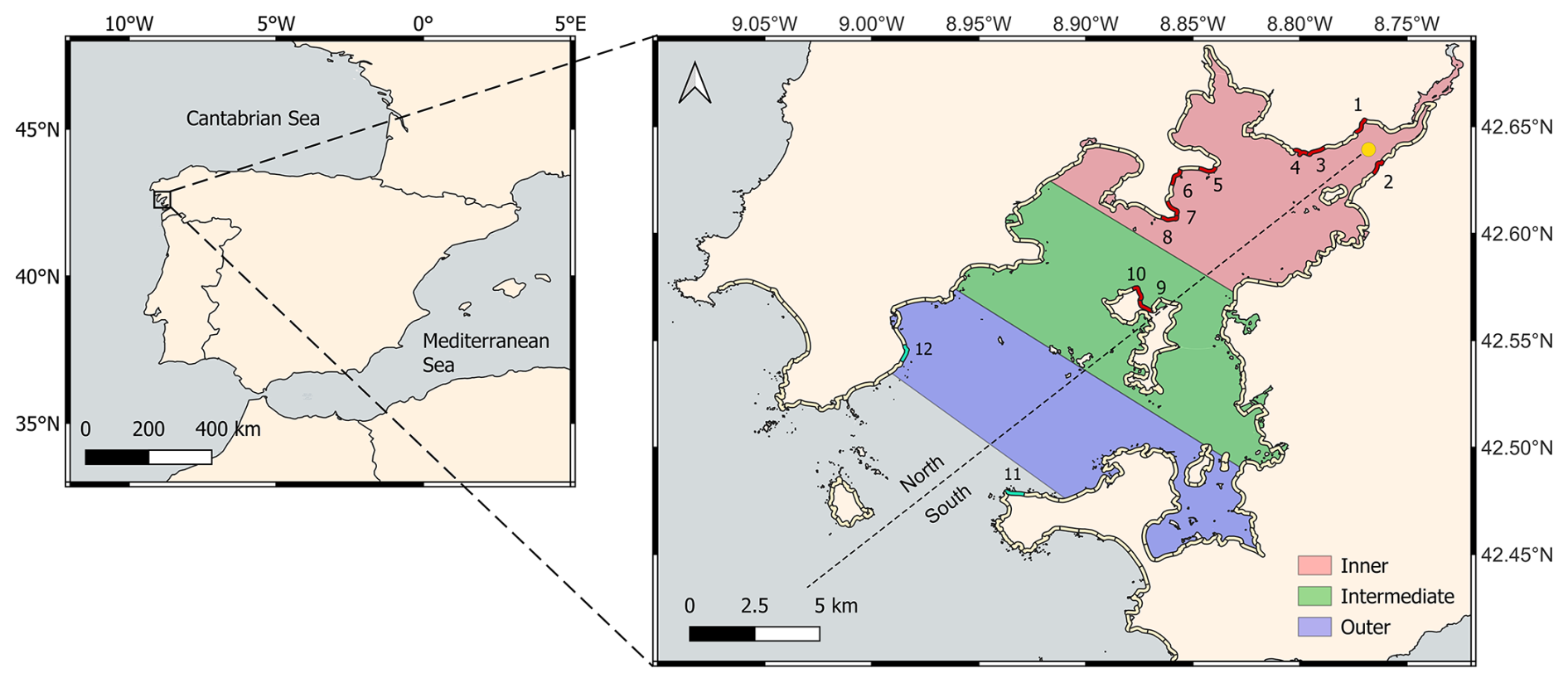
Figure 1Study region to evaluate riverine (yellow dot) debris dispersion in the Ría de Arousa (NW Spain), divided into inner, intermediate and outer zones of around 65 km2, as well as into North and South zones relative to its axis (dashed line). The coastal segments marked in red show the beaches used in the Results section and correspond to: (1) Ensenada de Rial, (2) Punta Remuiño, (3) Ensenada de Seveira, (4) Praia do Lodeiro, (5) Praia Redonda , (6) Praia de Piñeiro, (7) Praia da Ladeira, (8) O Chazo, (9) Praia do Arroás and (10) Praia do Nabal. Coastal segments marked in green are going to be taken as representatives for the external region, corresponding to (11) Praia do Carreiro and (12) Praia do Touro.
The movement of marine plastics through ocean currents remains poorly understood due to the influence of diverse spatial, temporal, and biogeochemical factors, as well as variations in plastic size and density (Cooper and Corcoran, 2012; Urbanek et al., 2018; Van Sebille et al., 2020). According to Chassignet et al. (2021), there is a pressing need for further studies to clarify these complex dynamics. Research on marine litter employs a variety of methods, including visual surveys, trawl nets, and drift traps, which capture floating debris and enable its categorization by size (Gago et al., 2019). Remote sensing tools, such as satellite imagery and drones, have also proven effective for identifying high-density litter zones (Davaasuren et al., 2018; Goddijn-Murphy and Williamson, 2019). In recent years, numerical modeling of plastic dispersion has advanced through the use of hydrodynamic models that simulate the pathways of plastics in oceans and rivers (Politikos et al., 2020; Chassignet et al., 2021; Cloux et al., 2024). Plastic transport can be modeled using passive Lagrangian tracers, which account for the rise or sinking of particles due to buoyancy and hydrodynamic forces such as Stokes drift and wind (Carlson et al., 2017; Turrell, 2020; Khoirunnisa et al., 2020; Sousa et al., 2021; Jalón-Rojas et al., 2019). Windage refers to the impact of surface winds on the parts of floating debris exposed above the ocean surface, and studies have shown that it can significantly influence the paths of large objects (Trinanes et al., 2016; Irfan et al., 2024). The impact of windage is determined by size, shape, and buoyancy of debris, with significant variability in the coupling strength between local wind conditions and the resulting windage velocity of the object (Jalón-Rojas et al., 2019).
The primary objective of this study is to investigate the influence of wind on the accumulation patterns of river-transported plastic debris in an estuarine, Ría de Arousa. Using Lagrangian particle tracking models, this study examines how wind conditions affect the distribution of floating particles, comparing accumulation along the shoreline. Additionally, the study explores the correlation between beached particles and river flow rate, as well as the residence time of debris within the estuary. By leveraging numerical simulations, this work provides insights into the key drivers of plastic retention and dispersion, contributing to a better understanding of pollutant transport and more effective mitigation strategies.
2.1 Study Area
Located in the northwestern part of Spain, Galicia features an extensive coastline measuring approximately 1498 km, according to the National Institute of Statistics. This coastal region is renowned for its diverse landscapes, with the Rías standing out as one of its most distinctive natural features. These estuarine systems are vital for the economy of the region, particularly in fishing and aquaculture, making Galicia one of the leading areas worldwide for shellfish production (Labarta et al., 2004). The Galician Rías are traditionally divided into Rías Altas and Rías Baixas, based on their location relative to Cape Finisterre, the westernmost point of the region.
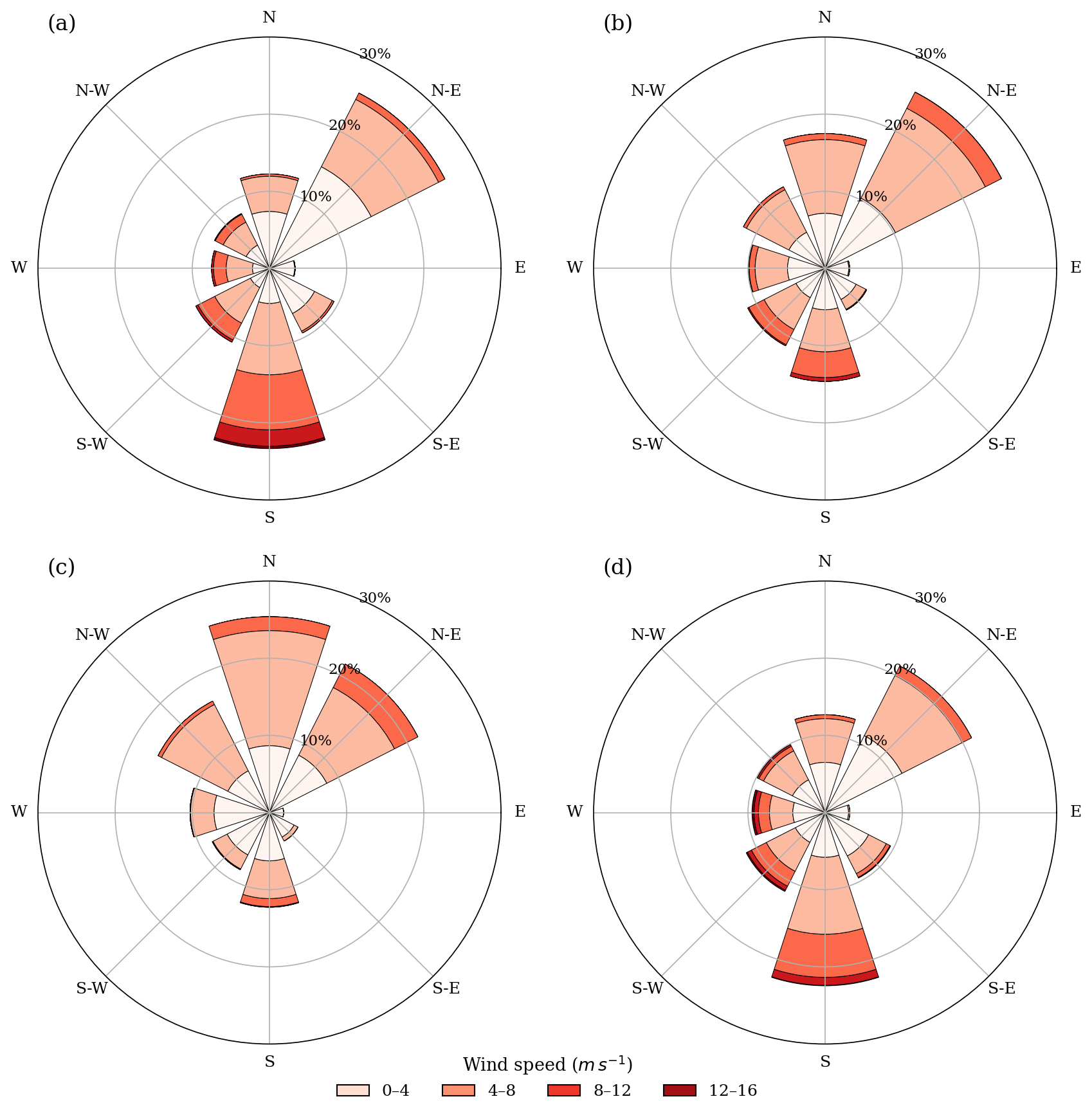
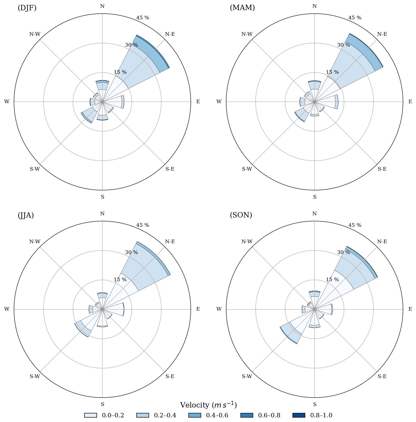
Figure 2Wind roses for the Ría de Arousa for winter DJF (a), spring MAM (b), summer JJA (c), and autumn SON (b) months.
Among the Rías Baixas, the Ría de Arousa (Fig. 1) is both the largest and deepest. According to Rosón et al. (1995), it stretches around 33 km in length, covering a surface area of approximately 230 km2, with a total volume close to 4.5 × 10⁹ m3 and a maximum depth exceeding 67 m in its central zone. The Ría de Arousa experiences a mean tidal range of about 3 m, classifying it as a mesotidal estuary. Wind patterns play a key role in influencing residual circulation both within the estuary and along the adjacent continental shelf (Rosón et al., 1995). Figure 2 shows average wind roses for a five-year period (2018–2023) in the Ría de Arousa region of Galicia, highlighting seasonal variations. In winter (Fig. 2a) and autumn (Fig. 2d), dominant winds tend to come from the northeast and south, with a noticeable frequency of stronger winds from the south. In contrast, summer winds (Fig. 2c) are predominantly from the north and northeast, with generally lower wind speeds. Spring months (Fig. 2b) show a mixed behaviour between colder and warmer months, while showing an important northeastern component. These seasonal patterns are important for understanding the effect of wind patterns on the debris transport in the Rías. Currents within the estuary are predominantly driven by the geometry of the domain, as their main directions align with the axis of the Ría as it is shown in the Appendix. The Galicia Costa hydrological district is responsible for managing water resources in this area, which consists of a complex network of coastal systems and estuaries. The Ulla River is the largest river that feeds into the Ría de Arousa, located at the extreme end of the estuary. Consistent rainfall patterns drive the perennial flow throughout the year, and it plays a crucial role in shaping the hydrological and ecological dynamics of the estuary.
2.2 Input data
Hydrodynamic and wind data have been obtained from the database of the regional meteorological service MeteoGalicia (https://www.meteogalicia.gal, last access: 25 January 2026) for the study period. The hydrodynamic data used in the simulation consist of reanalysis fields from the MOHID model, with a spatial resolution of 300 m and a temporal resolution of one hour. Only surface hydrodynamic fields were included for 2D simulations. Wind data were obtained from the operational WRF model, with a spatial resolution of 1.3 km and a temporal resolution of 1 h. Both datasets cover the period from December 2018 to December 2023. The simulation domain extends from 42.39 to 42.68° N and from 9.1 to 8.72° W.
Emissions from the Ulla River, the main source of freshwater for the Ría de Arousa, are used to represent river inflow. A single particle emission point is placed at the river's mouth (blue point marker at Fig. 1), at coordinates 42.635° N, 8.77° W. The emission rate is calculated using daily discharge data from the MeteoGalicia database's historical gauging records. Monthly averages are used when daily values are not available. Assuming that greater discharge translates into larger plastic emissions, particle emissions are scaled proportionately to river flow. To guarantee constant input to the Lagrangian model over the course of the five-year simulation period, particles were released from a fixed position at the river mouth. Six million particles over the research period were emitted, proportional to the mean daily flow rate as described in Cloux et al. (2024).
2.3 Numerical methods
In this study, the MOHID-Lagrangian model is used for computational simulations. This high-resolution tool has been widely applied to simulate the transport of marine debris and other floating objects. Developed within the MOHID modeling system (Campuzano et al., 2016), it tracks particle trajectories in the ocean using a Lagrangian approach, incorporating hydrodynamic forcing and other environmental influences, such as the wind. Its reliability has previously been assessed by comparing simulations with coastal monitoring data, demonstrating its capability to estimate the dispersion and accumulation of floating debris (Cloux et al., 2022; de Pablo et al., 2022). The model also includes a beaching parameterization, allowing users to set a shoreline interaction threshold, and define the probability of a particle becoming stranded (Cloux et al., 2024). Elevated probabilities indicate a high retention potential typical of rocky, vegetated, or geomorphologically complex shorelines (e.g., 80 %), while reduced coefficients are associated with gently sloping, sandy beaches that favor particle re-entrainment into the water (e.g., 20 %–30 %). These settings enable the simulation of different accumulation scenarios along the coastline. The particle trajectories are estimated as,
where and represent the particle's velocity from the hydrodynamic and 10 m wind fields interpolated at the particle position ri and time instant t. The term cw accounts for the windage effect on the plastic debris. The last term introduces a random component to the particle motion, allowing for the inclusion of small-scale turbulent effects that are not resolved at the current resolution of the simulation (Lebreton et al., 2012). The variable R is a randomly generated number from a continuous uniform distribution with zero mean and a standard deviation of 1. The parameter Kh = 1 m2 s−1 represents the coefficient for turbulent horizontal diffusion
To isolate the effect of wind on particle transport, we focused exclusively on surface currents and wind forcing, without explicitly including Stokes drift or other wave-related processes such as swell, which on the other hand are of small magnitude inside the Arousa estuary. Purely 2D surface simulations were performed, considering different windage forcing cw = 1 %, 3 %, 5 % (Galt, 1984; Lebreton et al., 2018; Seo and Park, 2020). This range is intended to account for the wide variety of plastic debris types found in the ocean, which differ significantly in terms of buoyancy, submersion levels, and exposure to wind. This windage coefficient is usually referred to be proportional to the ratio between surfaces of the plastic above and beneath the sea surface (Irfan et al., 2024). The coefficients were chosen to represent a variety of plastic debris of which transport was mostly governed either by wind (5 %) or ocean surface currents (1 %). The windage coefficient depends on the degree of particle exposure to air/water. Because it is challenging to simulate the full spectrum of plastic behavior in the marine environment, varying the windage parameter cw helps to approximate the transport patterns of plastics under different physical conditions. A 3 % windage is used as a reference, with 1 % and 5 % representing lower and higher sensitivity to wind, respectively
Throughout the simulation periods, Lagrangian particles have been released from the emission point according to the previously calculated emission rates at the sea surface. The shoreline interaction threshold for which beaching can occur was set at 3 m below surface. Given the nature of our study domain, having significant intertidal rocky areas, the beaching factor was set to 80 %. This high probability value was intentionally chosen to ensure that the majority of particles are retained within the domain, allowing us to focus on analyzing their behavior. In other words, we operate under a worst-case retention scenario in order to establish conservative estimates and robust statistical relationships
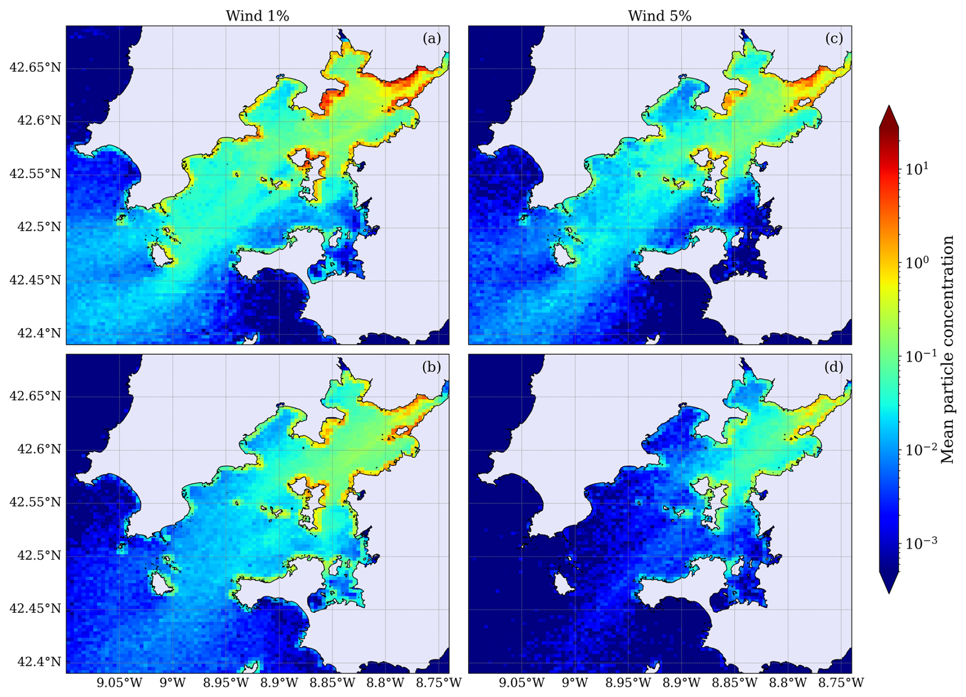
Figure 3Mean particle concentration distributions in the Ría de Arousa for winter (DJF; panels a and c) and summer (JJA; panels b and d) seasons, based on Lagrangian simulations using wind drag coefficients of 1 % (left panels) and 5 % (right panels). Color shading represents the logarithmic scale of mean particle concentration.
Simulations were run for a total period of five years, from December 2018 to December 2023. Additionally, results are analyzed seasonally, considering five winter (DJF), spring (MAM), summer (JJA), and autumn (SON) periods. An arbitrary spatial division of the Ría de Arousa was applied based on two criteria. First, as shown in Fig. 1, the estuary was segmented into three zones of similar area (around 65 km2) aligned approximately along a northeast–southwest axis: the outer zone, which is most influenced by oceanic conditions; the inner zone, which is least affected; and the intermediate zone, which lies between both. Second, the axis of the Ría was introduced, running from the river mouth to the ocean, which served as a basis to further subdivide the estuary into northern and southern sectors. Areas located above this diagonal were classified as the northern sector, while those below were classified as the southern sector. For each research period, the concentration of beached particles was estimated over a North-South distribution, based on whether they arrived to the coast above or below the axis of the Ría. The in-water concentration of particles for the whole domain is computed over a 300 m grid, by summing all particles at each grid cell over the study period, and then dividing that sum by the number of time steps in our simulation.
Residence times were computed as the time elapsed between particle arrival and exit at each subregion, provided that particles remained within the model domain. Calculations have been conducted based on the three subregions shown in Fig. 1. Particles leaving the computational domain were not included in the residence time calculation.
Figure 3 illustrates the mean accumulation patterns in the Ría de Arousa for winter (DJF) and summer (JJA) seasons, for two different wind drag coefficients: 1 % (left panels) and 5 % (right panels). For both seasons, lower wind drag (1 %) results in significantly higher nearshore and embayment accumulation, especially in the northern part of the estuary due to Coriolis force (Otto, 1975; Chase, 1975). This North–South assymetry and its modulation by wind forcing are consistent with the results of a non-stationary 2D hydrodynamic model of the Ría de Arousa, which explicitly incorporates Coriolis effects on residual circulation and demonstrates their coupling with wind and stratification (Rosón et al., 1997). Then, surface outflow of river water is stronger on the northern margin favouring beaching.
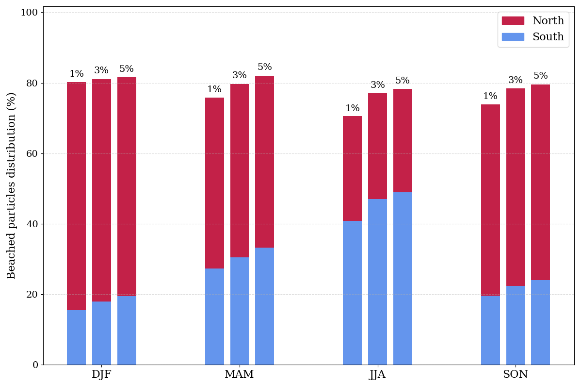
Figure 4Seasonal distribution of particle accumulation in the northern (red) and southern (blue) areas of the Ría de Arousa for three wind drag coefficients: 1 %, 3 %, and 5 %. Concentrations are grouped by season.
When the wind coefficient increases to 5 %, the overall particle concentration is reduced in the inner region and the accumulation becomes more diffuse, particularly during summer given that the north winds blow the particles out of the estuary. Particles generally drift towards southern regions with increased windage. Beached particles have not been taken into account when creating the concentration maps since they would distort the particle concentration in the sea. These results highlight the significant seasonal and geographical fluctuations in particle retention caused by wind forcing.
Beached particle distribution in the northern (red bars) and southern (blue bars) coasts of the Ría de Arousa for winter (DJF), spring (MAM), summer (JJA), and autumn (SON), for three different wind drag coefficients: 1 %, 3 %, and 5 % is shown in Fig. 4 as the percentage of beached particles out of all emitted in each season. A somewhat higher relative beaching is the result of higher wind coefficients. Throughout the winter and fall, higher populations are regularly seen along the northern coast. On the other hand, beaching along the southern coast grows and sometimes reaches the level of beaching in the north during the warmer months (JJA).
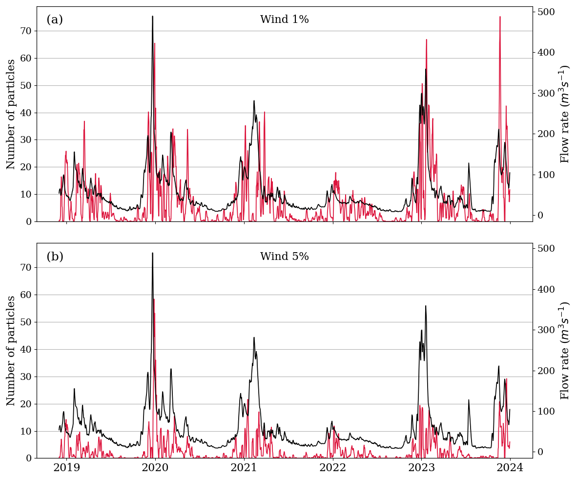
Figure 5Daily time series of number of beached particles for Ladeira beach (red) and Ulla river flow rate (black), for 1 % wind (a) and 5 % wind (b).
To further understand this dynamic, we investigate the link between beached particles and the mean flow rate of the Ulla River. Figure 5 depicts the relationship between particle beaching on one of the most contaminated beaches (Ladeira beach) in the inner region and the river outflow. Note the strong correlation between beaching and flow rate, mostly during raining seasons. For this beach, nearly no time lag was observed between flooding and beaching peaks due to its proximity to the river mouth
Table 1Correlation coefficients and the most frequent time lags (mode, in days) between river discharge and particle beaching for three windage scenarios (cw = 1 %, 3 %, 5 %), for the ten most polluted coastal segments in the study area. ID numbers correspond to locations shown in Fig. 1. For comparison two beaches located in the outer region (ID = 12) and the exterior zone (ID = 11) of the Ría were included.
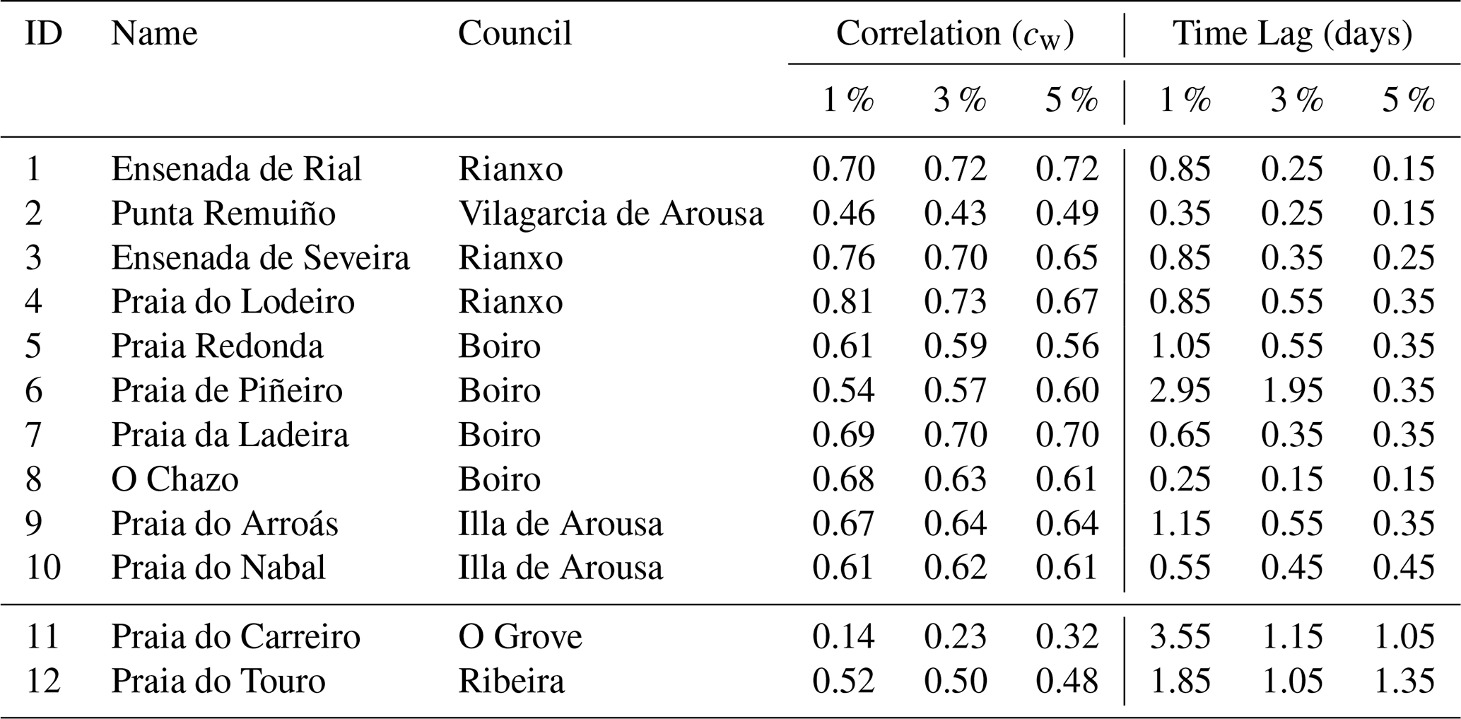
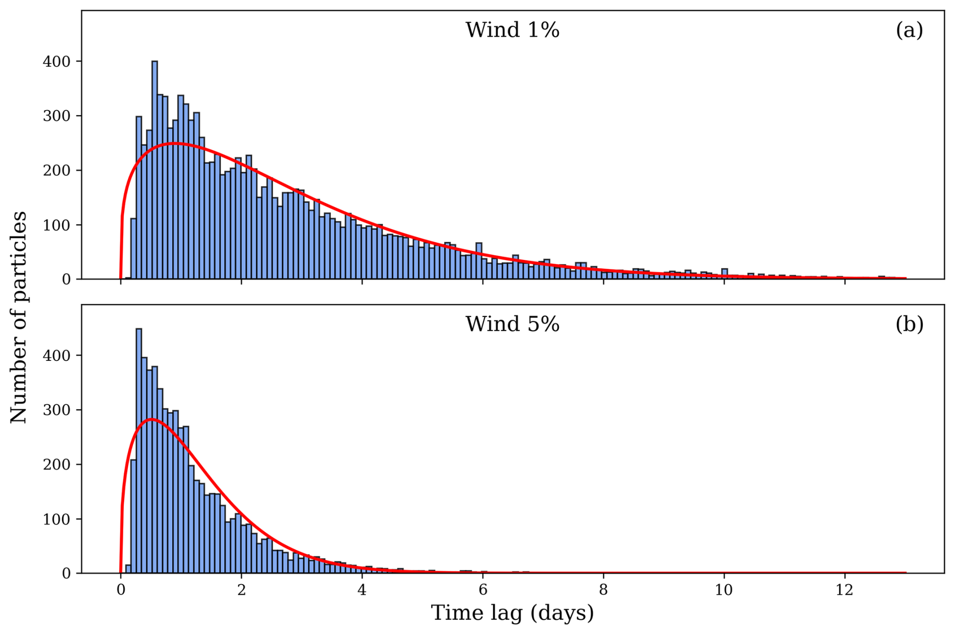
Figure 6Distribution of particle time lags beached at Ladeira beach (ID = 7) for 1 % (a) and 5 % (b) coefficient winds. Time lag data were fitted to a Weibull probability distribution (red line).
The time lag distribution of beached particles for two wind factors is displayed in Fig. 6. As anticipated for Lagrangian particles carried by wind and surface currents, the data fit a Weibull distribution quite well. As the wind coefficient decreases, the distribution gets wider. The correlation coefficient and the most common time lag between river discharge and particle beaching for three windage coefficients are displayed in Table 1. Because of the river plume effect, beaches O Chazo (ID = 8) and Nabal (ID = 10) have shorter time delays than beaches nearer the river mouth. As previously mentioned, northern beaches are more polluted during the winter and fall rainy seasons, which intensifies the river plume. The significance of geography and coastal currents is demonstrated by the fact that other beaches around those two have the biggest temporal lags. Conversely, as anticipated, time delays along the coast decrease by increased windage. Time lags for two beaches in the outside region are also displayed for comparison. Following up on our earlier statement, we should observe that while Touro Beach is situated on the northern coast and is directly affected by the river plume, its time lag (ID = 12) is lower than Carreiro Beach's (ID = 11). It is also of crucial importance to remind that the number of emitted particles is directly correlated with the riverine discharge.
Coastal segments located in the Rianxo area, situated on the northern side near the river mouth, consistently exhibit higher correlation coefficients between river discharge and particle accumulation. This behavior can be attributed to the proximity of these segments to the mouth of the river, which leads to earlier beaching of particles, reducing the extent to which they disperse throughout the estuary and thus preserving a stronger correlation with riverine input. In contrast, segments located farther from the river mouth generally show lower correlation coefficients, likely due to increased particle dispersion before reaching the shore, which weakens the direct influence of the river discharge. Overall, the northern part of the study area tends to exhibit stronger correlations. In contrast, at Punta Remuíño (ID = 2), located on the southern coast of the estuary, correlations are consistently lower. This behavior may be explained by the prevailing northeasterly winds, which tend to impede uniform particle deposition in this area.
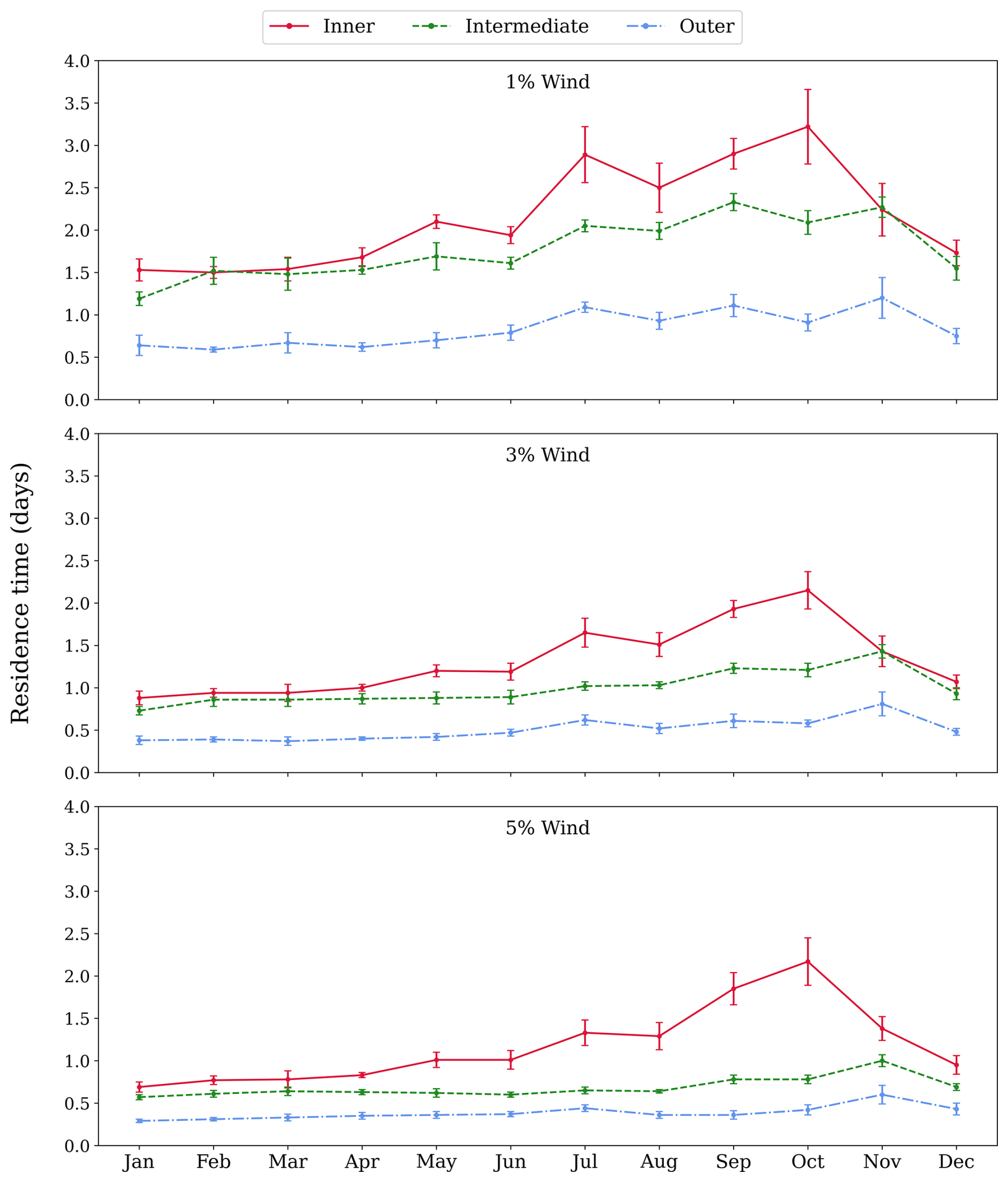
Figure 7Monthly residence times as a function of time for 1 %, 3 % and 5 % wind. Inner, intermediate, and outer regions correspond to solid red, dashed green and dot-dashed blue lines, respectively.
Residence time is an important parameter for evaluating estuary environmental water quality. Figure 7 depicts the monthly mean residence times for the three examined regions (inner, intermediate, and external) throughout time, as well as the three windage factors studied. Residence time is calculated by taking the average amount of time a particle spends in one of the defined zones. If a particle returns, after exiting, to one of these regions, a new counting is established. Similarly to what was proposed for the concentration maps in Fig. 3, beached particles have not been taken into account for this calculation, as their residence time keeps increasing after being beached. Also, particles that have exited the domain have not been considered either. This method to calculate the residence time differs from that in Huang et al. (2011); de Pablo et al. (2022) as in our case particles are continuously released from the river mouth. Increasing windage leads to a decrease of residence times as plastics are expelled faster resulting in reduced particle accumulation in all locations. A consistent residence time increase is observed in the second half of the year. This behavior can be explained by changes in the primary wind direction, as northerly breezes are gradually replaced by southwestern winds, which help to accumulate surface water in the estuary. River flow rate increases at the end of the year, when the rainy season begins, struggling with winds expelling water from the estuary. This results in the observed peak in the time series, which is delayed as the location is farther from the river mouth. The geographical nature of Ría de Arousa results in longer dwell durations in places closer to the release point. In addition to being closer to the emission source, the inner and intermediate zones experience more geographical features. The Coriolis effect causes particles from the river to enter the outer zone from the north side (see to Fig. 3) (Gilcoto et al., 2007), allowing for faster ejection from the estuary as that zone is free of geographical mishaps.
The results of this study underscore the critical role of wind forcing in modulating particle transport dynamics within semi-enclosed coastal systems such as the Ría de Arousa. One of the most significant findings is that even small increases in the wind drag coefficients (from 1 % to 5 %) result in markedly reduced particle accumulation along the coast, with both spatial extent and intensity of accumulation diminished. This clearly demonstrates that wind not only disperses particles more widely but also accelerates their removal from the estuary, effectively shortening their residence times.
The northern part of the estuary consistently shows higher particle retention, especially under low wind conditions and during colder months, suggesting a natural tendency for pollutants and floating debris to accumulate in impounded and sheltered regions. This asymmetry in distribution is further influenced by estuarine morphology and prevailing wind patterns, which may favor or hinder particle retention depending on location. In contrast to Cloux et al., 2022), who focused on large-scale coastal accumulation driven primarily by regional circulation, our results highlight the importance of local-scale processes within a semi-enclosed estuarine system. In particular, we show that the release location and estuarine morphology play a key role in shaping beaching and retention patterns, leading to markedly different outcomes even when using the same Lagrangian modeling framework.
Furthermore, the clear correlation between fluvial discharge and particle accumulation in the shore segments near the mouth reveals the dominant role of hydrological inputs when wind pressure is low. However, this correlation weakens with stronger winds, indicating a decoupling between fluvial inputs and deposition at the coast when wind becomes the main driver of transport. In this context, prevailing northeasterly winds appear to inhibit deposition at specific southern locations, such as Punta Remuíño, further highlighting the spatial complexity of wind-particle interactions. Similar results were observed in terms of beaching time lags.
The observed seasonal change, with greater accumulation in the southern part during the warmer months, implies a dynamic interaction between seasonal hydroclimatic variability and estuarine circulation patterns. This suggests that management and monitoring strategies should take into account temporal variability, especially when dealing with pollution episodes or designing cleanup measures.
Differences in particle residence times between regions reflect how geographic features, such as bathymetry, bays, and proximity to the emission source, interact with physical forcings to shape retention patterns. Inner and intermediate regions, characterized by more complex coastal geometry, retain particulate matter longer than the outer zone, reinforcing the idea that physical geography can substantially modulate the risk of exposure to pollutants.
Taken together, these results highlight the importance of incorporating realistic wind forcing into predictive models of marine debris and pollutant dispersion. They also point to the need for spatially targeted mitigation strategies, particularly in vulnerable areas with the greatest potential for accumulation.
Notwithstanding the insightful information this study offers, one of its primary drawbacks is the oversimplified beaching scheme that was used, which ignores the various coastline morphologies along the Ria. A more realistic representation of the dynamics of floating and stranded particles might be possible with a more advanced stranding model that could represent diverse coastal features in a single simulation. Moreover, wind-induced vertical mixing processes, which have been shown to significantly alter the vertical distribution of buoyant plastics (Kukulka et al., 2012), are not explicitly represented and may influence both particle availability for beaching and estimated retention patterns. This would provide us more precise estimates of retention and deposition patterns and enable us to move beyond the worst-case accumulation scenario as it was applied here. Furthermore, the study's use of plastic emissions following river flow is based on the best available assumptions, which may not correctly reflect the temporal or spatial diversity of actual discharge volumes. Even though our work does not primarily focus on quantifying plastic inputs, future research could benefit from incorporating more realistic emission estimates, perhaps using regression models or connectivity matrices that link the characteristics of watersheds to the production of pollutants. The incorporation of these data may improve the accuracy of source identification as well as our understanding of the relative contributions of different catchment regions.
On the other hand, increasing the hydrodynamic horizontal resolution and that of the wind model may resolve nearshore processes, many occurring within a few meters of the coast. Regarding dimensionality, the used model is two-dimensional and does not explicitly include vertical processes such as stratification or mixing. Although a 3D approach could refine residence times and pathways, the surface-oriented nature of the particles suggests that the main conclusions would remain qualitatively consistent.
The proposed methodology is transferable to other coastal and semi-enclosed systems – such as estuaries, bays, and rias – where circulation patterns and coastline geometry strongly influence particle accumulation. Its applicability primarily depends on the availability of sufficiently high-resolution hydrodynamic data to ensure that the beaching parameterization remains a realistic representation of coastal interactions.
Figure A1 shows the velocities, and directions of the hydrodynamic currents at the surface at a location in the inner region of the domain. Currents are predominantly driven by the geometry of the domain, as their main directions align with the axis of the Ría.
The code with the MOHID-Lagrangian model can be found in https://github.com/Mohid-Water-Modelling-System/MOHID-Lagrangian/tree/master (Garaboa-Paz and Birjukovs Canelas, 2026).
All utilized data are publicly avaliable via the THREDDS server at https://www.meteogalicia.gal/web/modelos-numericos/servidor-thredds (last access: 4 March 2026).
Conceptualization – MRO, VPM and SC. Data curation – MRO. Formal analysis – MRO, VPM. Funding acquisition – VPM. Investigation – MRO, VPM and SC. Methodology – MRO, VPM and SC. Project administration – VPM. Resources – MRO, VPM and SC. Software – MRO. Supervision – VPM and SC. Validation – MRO. Visualization – MRO, VPM and SC.Writing – MRO, VPM and SC.
The contact author has declared that none of the authors has any competing interests.
Publisher's note: Copernicus Publications remains neutral with regard to jurisdictional claims made in the text, published maps, institutional affiliations, or any other geographical representation in this paper. The authors bear the ultimate responsibility for providing appropriate place names. Views expressed in the text are those of the authors and do not necessarily reflect the views of the publisher.
We gratefully acknowledge financial support by FreeLitterAT Interreg Atlantic Project (EAPA-0009/2022), the Galicia Marine Science programme included in the Recovery, Transformation and Resilience Plan (PRTR-C17.I1), and the Xunta de Galicia (grant no. 2025-PG025).
This research has been supported by the Secretaria Xeral de Investigación e Desenvolvemento, Xunta de Galicia (grant nos. EAPA-0009/2022 and PRTR-C17.I1), FreeLitterAT Interreg Atlantic Project (grant no. EAPA-0009/2022), and Galicia Marine Science programme included in the Recovery, Transformation and Resilience Plan (grant no. PRTR-C17.I1).
This paper was edited by Damian Leonardo Arévalo-Martínez and reviewed by three anonymous referees.
Abalansa, S., El Mahrad, B., Vondolia, G. K., Icely, J., and Newton, A.: The marine plastic litter issue: A social-economic analysis, Sustainability (Switzerland), , https://doi.org/10.3390/su12208677, 2020. a
Akdogan, Z. and Guven, B.: Microplastics in the environment: A critical review of current understanding and identification of future research needs, Environmental Pollution, https://doi.org/10.1016/j.envpol.2019.113011, 2019. a
Campuzano, F., Brito, D., Juliano, M., Fernandes, R., de Pablo, H., and Neves, R.: Coupling watersheds, estuaries and regional ocean through numerical modelling for Western Iberia: a novel methodology, Ocean Dynamics, https://doi.org/10.1007/s10236-016-1005-4, 2016. a
Carlson, D. F., Suaria, G., Aliani, S., Fredj, E., Fortibuoni, T., Griffa, A., Russo, A., and Melli, V.: Combining litter observations with a regional ocean model to identify sources and sinks of floating debris in a semi-enclosed basin: The Adriatic Sea, Frontiers in Marine Science, , https://doi.org/10.3389/fmars.2017.00078, 2017. a
Carretero, O., Gago, J., Filgueiras, A. V., and Viñas, L.: The seasonal cycle of micro and meso-plastics in surface waters in a coastal environment (Ría de Vigo, NW Spain), Science of the Total Environment, https://doi.org/10.1016/j.scitotenv.2021.150021, 2022. a
Chase, J.: Wind-driven circulation in a Spanish estuary, Estuarine and Coastal Marine Science, 3, 303–310, https://doi.org/10.1016/0302-3524(75)90030-4, 1975. a
Chassignet, E. P., Xu, X., and Zavala-Romero, O.: Tracking Marine Litter With a Global Ocean Model: Where Does It Go? Where Does It Come From?, Frontiers in Marine Science, https://doi.org/10.3389/fmars.2021.667591, 2021. a, b
Cloux, S., Allen-Perkins, S., de Pablo, H., Garaboa-Paz, D., Montero, P., and Pérez-Muñuzuri, V.: Validation of a Lagrangian model for large-scale macroplastic tracer transport using mussel-peg in NW Spain (Ría de Arousa), Science of The Total Environment, 822, 153338, https://doi.org/10.1016/j.scitotenv.2022.153338, 2022. a, b
Cloux, S., Pérez, P., de Pablo, H., and Pérez-Muñuzuri, V.: A regional Lagrangian model to evaluate the dispersion of floating macroplastics in the North Atlantic Ocean from land and river sources in the western coast of Spain, Marine Pollution Bulletin, 209, 117110, https://doi.org/10.1016/j.marpolbul.2024.117110, 2024. a, b, c, d
Cooper, D. A. and Corcoran, P.: Effects of Chemical and Mechanical Weathering Processes on the Degradation of Plastic Debris on Marine Beaches Graduate Program in Geology, Electronic Thesis and Dissertation Repository, 2012. a
Davaasuren, N., Marino, A., Boardman, C., Alparone, M., Nunziata, F., Ackermann, N., and Hajnsek, I.: Detecting Microplastics Pollution in World Oceans Using Sar Remote Sensing, in: IGARSS 2018 – 2018 IEEE International Geoscience and Remote Sensing Symposium, pp. 938–941, https://doi.org/10.1109/IGARSS.2018.8517281, 2018. a
de Pablo, H., Sobrinho, J., Garaboa-Paz, D., Fonteles, C., Neves, R., and Gaspar, M. B.: The Influence of the River Discharge on Residence Time, Exposure Time and Integrated Water Fractions for the Tagus Estuary (Portugal), Frontiers in Marine Science, 8, 1–16, https://doi.org/10.3389/fmars.2021.734814, 2022. a, b
Gago, J., Filgueiras, A., Pedrotti, M. L., Caetano, M., and Frias, J.: Standardised protocol for monitoring microplastics in seawater, Deliverable 4.1, JPI-Oceans BASEMAN Project, https://doi.org/10.25607/OBP-605, 2019. a
Galt, J.: Oceanographic factors affecting the predictability of drifting objects at sea, in: Proceedings of the workshop on the fate and impact of marine debris, 27–29, 1984. a
Garaboa-Paz, D. and Birjukovs Canelas, R.: MOHID-Lagrangian, GitHub [code], last access: 25 January 2026. a
Gilcoto, M., Pardo, P. C., Álvarez Salgado, X. A., and Pérez, F. F.: Exchange fluxes between the Ría de Vigo and the shelf: A bidirectional flow forced by remote wind, Journal of Geophysical Research: Oceans, 112, https://doi.org/10.1029/2005JC003140, 2007. a
Goddijn-Murphy, L. and Williamson, B.: On thermal infrared remote sensing of plastic pollution in natural waters, Remote Sensing, 11, https://doi.org/10.3390/rs11182159, 2019. a
Huang, W., Liu, X., Chen, X., and Flannery, M. S.: Critical Flow for Water Management in a Shallow Tidal River Based on Estuarine Residence Time, Water Resources Management, 25, 2367–2385, https://doi.org/10.1007/s11269-011-9813-2, 2011. a
Hwang, J., Choi, D., Han, S., Jung, S. Y., Choi, J., and Hong, J.: Potential toxicity of polystyrene microplastic particles, Scientific Reports, https://doi.org/10.1038/s41598-020-64464-9, 2020. a
Irfan, T., Isobe, A., and Matsuura, H.: A particle tracking model approach to determine the dispersal of riverine plastic debris released into the Indian Ocean, Marine Pollution Bulletin, 199, 115985, https://doi.org/10.1016/j.marpolbul.2023.115985, 2024. a, b
Jalón-Rojas, I., Wang, X. H., and Fredj, E.: A 3D numerical model to Track Marine Plastic Debris (TrackMPD): Sensitivity of microplastic trajectories and fates to particle dynamical properties and physical processes, Marine Pollution Bulletin, 141, 256–272, https://doi.org/10.1016/j.marpolbul.2019.02.052, 2019. a, b
Jambeck, J. R., Geyer, R., Wilcox, C., Siegler, T. R., Perryman, M., Andrady, A., Narayan, R., and Law, K. L.: Plastic waste inputs from land into the ocean, Science, https://doi.org/10.1126/science.1260352, 2015. a
Khoirunnisa, H., Wibowo, M., and Hendriyono, W.: Determination of Construction Design to Reduce the Amount of Marine Litter at Seawater Intake Using Particle Tracking Module of Numerical Method by Mike 21 (Case Study: Tanjung Awar – Awar, Tuban, East Java), Journal of Physics: Conference Series, https://doi.org/10.1088/1742-6596/1625/1/012045, 2020. a
Kukulka, T., Proskurowski, G., Morét-Ferguson, S., Meyer, D. W., and Law, K. L.: The effect of wind mixing on the vertical distribution of buoyant plastic debris, Geophysical Research Letters, 39, https://doi.org/10.1029/2012GL051116, 2012. a
Labarta, U., Fernández-Reiriz, M., Camacho, A. P., and Pérez-Corbacho, E.: Mussels-farmers, Sea, Mussels: A Bioeconomic Perspective, Fundación Caixa Galicia, Santiago de Compostela, 2004 (in Spanish). a
Lebreton, L., Slat, B., Ferrari, F., Sainte-Rose, B., Aitken, J., Marthouse, R., Hajbane, S., Cunsolo, S., Schwarz, A., Levivier, A., Noble, K., Debeljak, P., Maral, H., Schoeneich-Argent, R., Brambini, R., and Reisser, J.: Evidence that the Great Pacific Garbage Patch is rapidly accumulating plastic, Scientific Reports, 8, 4666, https://doi.org/10.1038/s41598-018-22939-w, 2018. a
Lebreton, L.-M., Greer, S., and Borrero, J.: Numerical modelling of floating debris in the world’s oceans, Marine Pollution Bulletin, 64, 653–661, https://doi.org/10.1016/j.marpolbul.2011.10.027, 2012. a
Li, Y., Zhang, H., and Tang, C.: A review of possible pathways of marine microplastics transport in the ocean, Anthropocene Coasts, https://doi.org/10.1139/anc-2018-0030, 2020. a
Min, K., Cuiffi, J. D., and Mathers, R. T.: Ranking environmental degradation trends of plastic marine debris based on physical properties and molecular structure, Nature Communications, https://doi.org/10.1038/s41467-020-14538-z, 2020. a
Morales-Caselles, C., Viejo, J., Martí, E., González-Fernández, D., Pragnell-Raasch, H., González-Gordillo, J. I., Montero, E., Arroyo, G. M., Hanke, G., Salvo, V. S., Basurko, O. C., Mallos, N., Lebreton, L., Echevarría, F., van Emmerik, T., Duarte, C. M., Gálvez, J. A., van Sebille, E., Galgani, F., García, C. M., Ross, P. S., Bartual, A., Ioakeimidis, C., Markalain, G., Isobe, A., and Cózar, A.: An inshore–offshore sorting system revealed from global classification of ocean litter, Nature Sustainability, 4, 484–493, https://doi.org/10.1038/s41893-021-00720-8, 2021. a
Otto, L.: Oceanography of the Ría de Arosa (N. W. Spain), Koninklijk Nederlands Meteorologisch Instituut, Mededelingen en verhandelingen, Staatsuitgeverij, https://books.google.es/books?id=iZYSAQAAIAAJ (last access: 25 January 2026), 1975. a
Politikos, D. V., Tsiaras, K., Papatheodorou, G., and Anastasopoulou, A.: Modeling of floating marine litter originated from the Eastern Ionian Sea: Transport, residence time and connectivity, Marine Pollution Bulletin, https://doi.org/10.1016/j.marpolbul.2019.110727, 2020. a
Rangel-Buitrago, N., Williams, A., Costa, M. F., and de Jonge, V.: Curbing the inexorable rising in marine litter: An overview, Ocean and Coastal Management, https://doi.org/10.1016/j.ocecoaman.2020.105133, 2020. a
Rosón, G., Pérez, F. F., Alvarez-Salgado, X. A., and Figueiras, F. G.: Variation of both thermohaline and chemical properties in an estuarine upwelling ecosystem: Ria de arousa: I. Time evolution, Estuarine, Coastal and Shelf Science, https://doi.org/10.1006/ecss.1995.0061, 1995. a, b
Rosón, G., Alvarez-Salgado, X., and Pérez, F.: A Non-stationary Box Model to Determine Residual Fluxes in a Partially Mixed Estuary, Based on Both Thermohaline Properties: Application to the Ria de Arousa (NW Spain), Estuarine, Coastal and Shelf Science, 44, 249–262, https://doi.org/10.1006/ecss.1996.0127, 1997. a
Seo, S. and Park, Y.-G.: Destination of floating plastic debris released from ten major rivers around the Korean Peninsula, Environment International, 138, 105655, https://doi.org/10.1016/j.envint.2020.105655, 2020. a
Sousa, M. C., DeCastro, M., Gago, J., Ribeiro, A. S., Des, M., Gómez-Gesteira, J. L., Dias, J. M., and Gomez-Gesteira, M.: Modelling the distribution of microplastics released by wastewater treatment plants in Ria de Vigo (NW Iberian Peninsula), Marine Pollution Bulletin, https://doi.org/10.1016/j.marpolbul.2021.112227, 2021. a
Trinanes, J. A., Olascoaga, M. J., Goni, G. J., Maximenko, N. A., Griffin, D. A., and and, J. H.: Analysis of flight MH370 potential debris trajectories using ocean observations and numerical model results, Journal of Operational Oceanography, 9, 126–138, https://doi.org/10.1080/1755876X.2016.1248149, 2016. a
Turrell, W. R.: How litter moves along a macro tidal mid-latitude coast exposed to a coastal current, Marine Pollution Bulletin, https://doi.org/10.1016/j.marpolbul.2020.111600, 2020. a
Urbanek, A. K., Rymowicz, W., and Mirończuk, A. M.: Degradation of plastics and plastic-degrading bacteria in cold marine habitats, Applied Microbiology and Biotechnology, 102, https://doi.org/10.1007/s00253-018-9195-y, 2018. a
Van Sebille, E., Aliani, S., Law, K. L., Maximenko, N., Alsina, J. M., Bagaev, A., Bergmann, M., Chapron, B., Chubarenko, I., Cózar, A., Delandmeter, P., Egger, M., Fox-Kemper, B., Garaba, S. P., Goddijn-Murphy, L., Hardesty, B. D., Hoffman, M. J., Isobe, A., Jongedijk, C. E., Kaandorp, M. L., Khatmullina, L., Koelmans, A. A., Kukulka, T., Laufkötter, C., Lebreton, L., Lobelle, D., Maes, C., Martinez-Vicente, V., Morales Maqueda, M. A., Poulain-Zarcos, M., Rodríguez, E., Ryan, P. G., Shanks, A. L., Shim, W. J., Suaria, G., Thiel, M., Van Den Bremer, T. S., and Wichmann, D.: The physical oceanography of the transport of floating marine debris, Environmental Research Letters, https://doi.org/10.1088/1748-9326/ab6d7d, 2020. a
Vermeiren, P., Muñoz, C. C., and Ikejima, K.: Sources and sinks of plastic debris in estuaries: A conceptual model integrating biological, physical and chemical distribution mechanisms, Marine Pollution Bulletin, https://doi.org/10.1016/j.marpolbul.2016.10.002, 2016. a
Wayman, C. and Niemann, H.: The fate of plastic in the ocean environment-a minireview, Environmental Science: Processes and Impacts, 23, 198–212, https://doi.org/10.1039/d0em00446d, 2021. a
Williams, A. and Rangel-Buitrago, N.: Marine Litter: Solutions for a Major Environmental Problem, Journal of Coastal Research, 35, 648, https://doi.org/10.2112/JCOASTRES-D-18-00096.1, 2019. a
Zhao, S., Kvale, K. F., Zhu, L., Zettler, E. R., Egger, M., Mincer, T. J., Amaral-Zettler, L. A., Lebreton, L., Niemann, H., Nakajima, R., Thiel, M., Bos, R. P., Galgani, L., and Stubbins, A.: The distribution of subsurface microplastics in the ocean, Nature, 641, 51–61, https://doi.org/10.1038/s41586-025-08818-1, 2025. a