the Creative Commons Attribution 4.0 License.
the Creative Commons Attribution 4.0 License.
 | 18 Jun 2021
Preface: Developments in the science and history of tides
J. A. Mattias Green
Richard D. Ray
John M. Huthnance
This special issue marks the 100th anniversary of the founding of the Liverpool Tidal Institute (LTI), one of a number of important scientific developments in 1919. The preface gives a brief history of how the LTI came about and the roles of its first two directors, Joseph Proudman and Arthur Doodson. It also gives a short overview of the research on tides at the LTI through the years. Summaries are given of the 26 papers in the special issue. It will be seen that the topics of many of them could be thought of as providing a continuation of the research first undertaken at the LTI. Altogether, they provide an interesting snapshot of work on tides now being made by groups around the world.
- Article
(3046 KB) - Full-text XML
- BibTeX
- EndNote


The idea for this special issue on tides came about when we realised that the 100th anniversary of the founding of the Liverpool Tidal Institute (LTI) was coming up in 2019, and we thought that a special issue of a journal would be one good way of celebrating it. The year following the end of the First World War saw the establishment of a number of organisations which have had a lasting importance for geophysical research. Notably, the International Union of Geodesy and Geophysics (IUGG) was founded in that year (Ismail-Zadeh and Joselyn, 2019). In addition, as examples at a national level, the American Geophysical Union (AGU) and American Meteorological Society (AMS) were established in the same year (McEntee, 2018; McFarquhar, 2020).
The suggestion for a special institute in the UK dedicated to research on tides can be said to have arisen from a report written in 1916 for the British Association for the Advancement of Science (BAAS) by Sir Horace Lamb, professor of applied mathematics at Manchester, and Joseph Proudman, a lecturer in applied mathematics at Liverpool (Fig. 1). The proposal was accepted by Liverpool University and funding was obtained from Sir Alfred and Charles Booth of the Booth Shipping Line in order to “prosecute continuously scientific research into all aspects of knowledge of the tides” (Doodson, 1924; Cartwright, 1980, 1999). These are the basic facts, although Carlsson-Hyslop (2020) has described how the founding of the LTI came about only after a considerable amount of prior discussion and argument between the various stakeholders in academia (including Liverpool University and the BAAS), industry (including the Mersey Docks and Harbour Board) and the Navy (Admiralty).
The first LTI office was set up in March 1919 in the George Holt Building (then the physics building) on the Liverpool University campus.1 Proudman became its honorary (unpaid) director while Arthur Doodson was recruited as its secretary. Proudman continued with his other university responsibilities and was promoted to professor of applied mathematics. Meanwhile, in that same year, Liverpool University established the first university oceanography department in the UK.
However, space was short at the university after the war, and during the 1920s the LTI relocated across the river Mersey to Bidston Observatory in the Wirral, where there was more room for research and where Doodson took up residence in 1929, now as associate director (Nature, 1928). Proudman transferred from applied mathematics to be professor of oceanography in 1933, a position which he held until retirement in 1954, having handed over as director of the LTI to Doodson in 1945. By then, the LTI had become an acknowledged centre of expertise for research into ocean and earth tides, and it was to further extend its reputation in the following years into research on storm surges, sea level changes (Permanent Service for Mean Sea Level), and the measurement and modelling of coastal and shelf processes. The LTI underwent many name changes through the years, most notably being renamed as the Proudman Oceanographic Laboratory twice in 1987 and 2000, and became a component of the present National Oceanography Centre in 2010.
Proudman and Doodson both became Fellows of the Royal Society. Proudman was particularly expert on the dynamical theories of tides, and he played a major role in international collaboration in oceanography, being secretary and then president of the International Association of Physical Oceanography (IAPO, Smythe-Wright et al., 2019). Doodson was superb at simplifying large numerical calculations in the days before digital computers. One topic in which he excelled was tidal prediction, from both a theoretical foundation (his development of the tidal potential, Doodson, 1921) and in practical application (the construction and use of tidal prediction machines (TPMs), see below). These topics and other historical aspects of work at the LTI will be mentioned briefly. Excellent biographies of Proudman and Doodson can be found in Cartwright and Ursell (1976) and Proudman (1968) respectively.
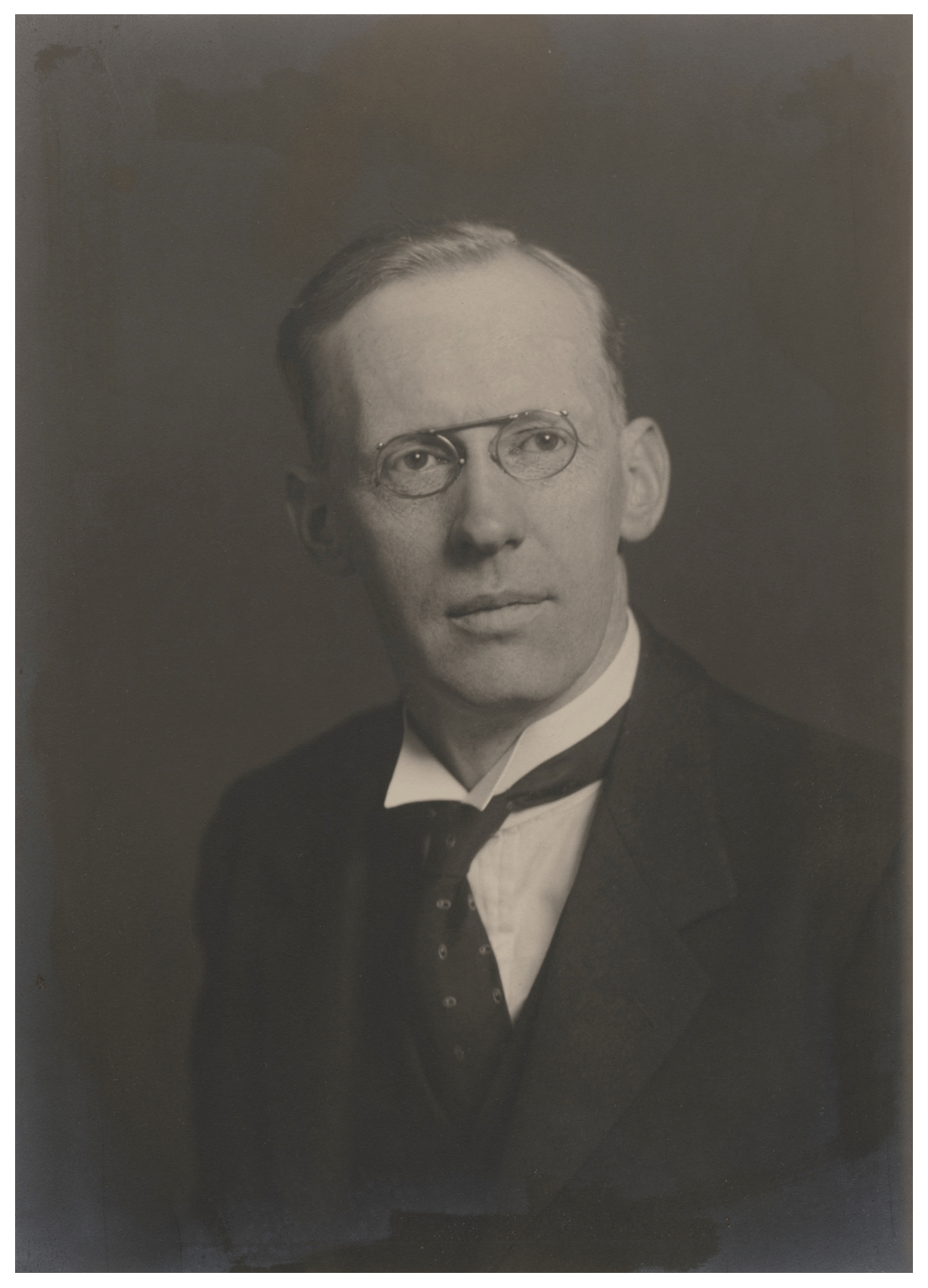
Figure 1Joseph Proudman CBE, FRS (1888–1975) photographed in 1931 by Walter Stoneman. © National Portrait Gallery, London.
A special issue such as this was ideally suited to the European Geosciences Union (EGU) family of journals published by Copernicus. Tides occur in the ocean, solid earth and atmosphere, with each of those areas of research being served by one or more journals. However, Copernicus provides a good mechanism for papers to appear in their individual journals and be linked together eventually to provide an overall special issue.
The executive editors of five journals agreed to be involved in the special issue, the largest number to have taken part in a special issue so far. However, in the event, papers contributed to the issue were published in only three journals: History of Geo- and Space Sciences, Solid Earth and, in particular, Ocean Science. These three journals cover more than adequately most of the research into tides which was undertaken at the LTI and also a great deal of the tidal research which is being conducted today. Potential authors were invited to address virtually any aspect of research into ocean or earth tides including the history of that research. As examples, the former could possibly include the present accuracy of coastal, regional and global tide models, tidal dissipation and its role in geophysics, internal tides and their role in mixing the ocean and in the global ocean circulation, secular changes in tides, and new techniques for measuring tides and analysing the data. The special issue opened for submissions on 1 January 2018 and stayed open through 2019 to take advantage of new findings presented at the AGU, EGU and IUGG conferences in that year. It closed finally to new submissions in the middle of 2020, having received and accepted 26 papers across the three journals.
To complement the special issue, a number of special sessions on tides were held at international conferences. These included presentations on tides at the EGU General Assembly in Vienna in April 2019 and the IUGG General Assembly in Montreal in July 2019. Events were also held locally to mark the LTI anniversary, including a large meeting for the public at the Merseyside Maritime Museum in May 2019 (Woodworth, 2020b) and in talks to Liverpool history groups.
2.1 History of tidal science in the special issue
One of the first papers in the special issue was concerned with the tidal data obtained by James Cook during his remarkable voyage to Tahiti to observe the Transit of Venus followed by the first landings by Europeans in New Zealand and Australia (Woodworth and Rowe, 2018). This paper marked yet another anniversary in 2019, in this case being 250 years since Cook's arrival at Tahiti. The paper discusses how puzzled Cook was by diurnal inequality in the tide along the Queensland coast, a factor which led to the near-sinking of the Endeavour, and diurnal inequality was later to be an important aspect of tidal research in the 19th century.
Agnew (2020) discusses how tidal fluctuations in gravity played an important role in the accuracy of timing measurements using pendulum clocks, which were up until the 1940s the best timekeepers available. The paper shows that the best pendulum clocks were able to detect tides long before the advent of measurements by gravimeters or Global Navigation Satellite System (GNSS) technology. This particular aspect of pendulum clocks does not appear to have been addressed at the LTI. However, good timing was certainly one of the LTI's general interests, as it had been in Liverpool since the middle of the 19th century, first by the astronomer John Hartnup of the Liverpool Observatory at Waterloo Dock and then at Bidston Observatory.2 Recent papers (not in the special issue) discuss how timing formed an important aspect of local scientific research and services over many years. These include the famous time transfer experiments between Liverpool and Boston; the provision of a chronometer calibration service for seafarers; and through the time control of the Liverpool One O'Clock Gun and time balls (Schmidt and Dearden, 2019, 2020; Thomas and Thomas, 2020a, b).
Other historical topics are addressed by Carlsson-Hyslop (2020), who, as mentioned above, provides many details of the complicated discussions which resulted in the founding of the LTI. One topic mentioned in that paper concerns the importance of the provision of tidal predictions to its overall finances. The use of TPMs became essential to such work, as discussed by Woodworth (2020a), and the LTI, under the direction of Doodson, became a world leader in the design and operation of TPMs.
Finally, a reminder that tidal measurements have a long history in many other countries is provided by Raicich (2020), who discusses recording at Trieste since 1782. This paper is an example of what has become known as “data archaeology”, whereby the information contained in sometimes vulnerable paper records is being converted into computer form so that the important data can be used in studies of long-term climate change.
2.2 Tidal science at the LTI
The history of a branch of science can often be marked by the introduction of new technologies which have revolutionised and reinvigorated the research. Tidal science, and sea-level science in general, provides a good example. In the following, we mention some of the research areas at the LTI which involved tides and sea levels and which benefitted from new technology. This provides one way of relating the LTI's history to the research papers contained in the special issue. The areas are elaborated on in the following subsections.
2.2.1 Tidal prediction
Woodworth (2020a) explains how it became possible to determine tidal harmonic constants from a set of tide gauge data. In principle, these constants could be used to provide tidal predictions by means of tedious hand computations. However, the technological leap provided by Kelvin's invention of the TPM, a type of analogue computer, speeded up the determination of predictions considerably. Between the 1870s and 1960s, over 30 TPMs were constructed around the world, of which the majority were made in the UK. Only three of them were used for tidal prediction at the LTI itself. However, there were more for which Doodson played a major role in their design or supervised closely their manufacture. Of course, TPMs were superseded by another technological leap, the advent of digital computers in the 1960s.
2.2.2 Storm surge modelling
Proudman (1968) remarked that towards the end of Doodson's tenure as LTI director he strenuously opposed the use of modern digital computers, claiming that they would increase the cost of providing tidal predictions to harbour authorities. That reservation is understandable given Doodson's lifetime involvement with the TPMs and the fact that they were still a source of income. It was left to his successor Jack Rossiter to introduce modern computers to the LTI.
The study of “meteorological effects on the tides” (i.e. storm surges) had been included in the LTI's terms of reference since its founding. However, the study was given impetus by the major floods of 1953 (Wolf and Flather, 2005). Attempts were made by Shizuro Ishiguro at the National Institute of Oceanography (NIO) in the UK (in the south of England, not then associated with the LTI) to predict surges using electronic analogue computers (Kennard, 2016; Wolf, 2017). However, the work became much easier once advances in technology had led to the availability of powerful digital computers. In turn, this enabled the development of numerical storm surge models. Work at the LTI was led by Norman Heaps and Roger Flather (e.g. Heaps, 1983), with their models adopted for operational use by the Meteorological Office and Environment Agency for flood warning around the coast of the UK and control of the Thames Barrier.
2.2.3 Sea level measurements
The measurement of the tide, and sea level variations in general, using tide gauges has always been an LTI interest. In 1933, Doodson together with Chadburns of Liverpool installed instrumentation to the tide gauge in Birkenhead docks, two miles (4 km) away, so that data could be transmitted to Bidston Observatory, an early example of near-real-time data reporting. He also designed a current meter for use on annual Irish Sea cruises (Proudman, 1968) (Fig. 2). Eventually, the LTI became a centre of expertise for tide gauge technology and was responsible for ongoing sea level measurements in both the UK and abroad. It also became a data centre for tide gauge information, the UK data being quality controlled by the British Oceanographic Data Centre, and mean sea level information from around the world being archived by the international Permanent Service for Mean Sea Level (PSMSL, https://www.psmsl.org, last access: 1 June 2021). The latter had been initiated at Bidston in 1933 with Proudman as its first secretary. The PSMSL has become one of the main services of the International Association for the Physical Sciences of the Oceans (Smythe-Wright et al., 2019), and its data set is used within a wide range of geophysical research, including the regular scientific assessments of the Intergovernmental Panel on Climate Change (IPCC).
Doodson also experimented in the 1930s with a number of Favé pressure gauges with which measurements of the tide offshore were obtained. However, it was not until the 1960s that the serious measurement of deep-sea tides using bottom pressure records (BPRs) began in the UK, led by the group of David Cartwright at the NIO. That small team transferred to Bidston Observatory in 1974 when Cartwright became assistant director of the Institute of Oceanographic Sciences (Bidston), as the LTI was then called. Cartwright's contribution to tidal science in the latter half of the 20th century was immense, and he raised the intellectual level of the institute's contribution enormously. The team became the world leaders in the measurement of tides at depths down to 5000 m (Fig. 3). The same instruments were also used for ocean transport measurements during the World Ocean Circulation Experiment (WOCE) (Spencer and Vassie, 1997). Cartwright's own interests in sea level measurements were to be extended later into the use of satellite altimeter data, mostly in studies of tides, in collaboration with US and UK researchers. Cartwright became the third Fellow of the Royal Society associated with the LTI. A detailed biography may be found in Webb (2017).
2.2.4 Earth tides
Bidston Observatory has two levels of basements cut into the sandstone of Bidston Hill. In 1909, a horizontal pendulum seismometer was installed by John Milne, specifically to study the tidal loading of the solid Earth. This showed clearly the tilt in the north–south direction due to loading by the tide in the adjacent Irish Sea (Milne, 1910).
After measurements using different instruments over many years by different groups, it was concluded that tilt measurements were overly sensitive to local geology (Baker, 1980), and gravity measurements took their place, the Bidston research group being equipped with LaCoste and Romberg Earth tide meters. These were used at many locations in the UK and abroad, and the measurements by the Bidston group were shown to be particularly accurate due to their unique electrostatic feedback mechanism and the careful recalibration of the gravimeters on the Hanover gravity baseline in Germany. From the mid-1980s onwards, superconducting gravimeters were deployed at a number of sites around the world (but not in the UK), with calibrations mainly provided by new Micro-g LaCoste FG5 absolute gravity meters (see below). The results from these superconducting gravimeters are in close agreement with the earlier results of the Bidston group's LaCoste and Romberg Earth tide gravimeters (Baker and Bos, 2003).
The development of GNSS technology in the 1990s, of which the Global Positioning System (GPS) is the most well-known, enabled the vertical variations of the loading tide to be measured in a global reference frame for the first time (and also its smaller horizontal components). The LTI group was among the first to demonstrate the capabilities of GNSS in this way, and it is now the main technique for tidal loading studies. The result of all this body of work has been to demonstrate which ocean tide models are more accurate than others, through computation of their corresponding loading tide distributions, followed by comparison of those distributions to the gravimeter or GNSS data. In addition, one learns a considerable amount concerning the physical properties of the solid Earth (Bos et al., 2015). For an authoritative history of this part of the LTI's research, the reader is referred to the unpublished article by Baker (2016).
2.2.5 Geodetic measurements
Alongside the GNSS measurements for tidal loading studies, the LTI group embarked in the 1990s on collaborative research, especially with Nottingham University, on using the technique to measure long-term rates of vertical land movements in the UK. Such GNSS data sets are now used by many groups around the world in order to remove land movements from time series of relative sea level measurements provided by tide gauges. This is becoming a well-established technique, although problems remain, such as the stability of the reference frame in which measurements are made (Wöppelmann and Marcos, 2016). Eventually, the group also acquired two Micro-g LaCoste FG5 absolute gravity meters, which measure small changes in the local acceleration due to gravity that can be interpreted as equivalent to changes in vertical land movement (e.g. Teferle et al., 2006). However, although absolute gravity continues to be used by other groups, especially where land movements are particularly large (e.g. due to glacial isostatic adjustment in Canada), it is no longer used in this role in the UK.
2.2.6 Other research
The above sub-headings inevitably omit those research topics at the LTI which were not particularly dependent on technology but which nevertheless had an important connection to tidal science. The most obvious ones are the many dynamical studies of Proudman, a good summary of which can be found in Cartwright (1980). They also omit many other aspects of the LTI's work which are less applicable to the special issue. These include studies of coastal and shelf processes, modelling of water quality and ecosystems, and investigations into the use of wave and tidal energy. For a more complete overview of work at the LTI, the reader might consult publications such as Scoffield (2006) or its regular reports through the years.
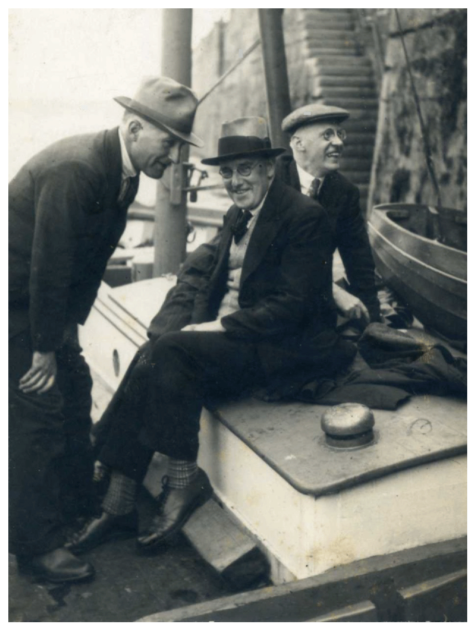
Figure 2Joseph Proudman (right), Arthur Doodson (centre) and Richard Daniel, a marine biologist from Liverpool University (left), during an Irish Sea cruise in the late 1930s aboard the Zephyr. Photograph courtesy of Valerie Gane. Other photographs of Doodson may be found in Carlsson-Hyslop (2020) and Woodworth (2020a).

Figure 3David Cartwright, FRS (1926–2015) (left) and colleagues around a “Mark IV” bottom pressure recorder deployed to measure the tide in over 3000 m of water NE of the Azores in 1980. Others appearing in the photograph (left to right): Ken Parry, Ian Vassie, Bev Hughes and Bob Spencer. Photograph courtesy of the National Oceanography Centre.
2.3 Tidal science in the special issue
It is possible to make connections in many cases between papers in the special issue and the areas of work at the LTI mentioned above.
For example, Woodworth and Hibbert (2018) discuss long-period ocean tides (Mf, Mm and Mt) in the Drake Passage and how their variation over a nodal cycle compares to expectations from the equilibrium tide. They were indeed found to vary as expected. However, such a study would have been impossible without the many years of BPR measurements in that “choke point” area undertaken for the WOCE and in the following years.
The term “radiational potential” was introduced by Walter Munk to account for motions of a tidal nature, which are caused, directly or indirectly, by the Sun's radiation, instead of being of astronomical tidal origin due to the Moon or Sun. Radiational tides include seasonal and diurnal variations due to varying meteorological forcings. In addition, there are important non-astronomical seasonal variations in sea level due to steric (density) changes in the ocean. The magnitude of such radiational tidal contributions was estimated by Cartwright and Tayler (1971), work which came just before Cartwright's move to the LTI. Williams et al. (2018) take a fresh look at these quasi-tidal variations and consider how they may be double-counted in storm surge forecasts and also how estimates of Highest Astronomical Tide might be affected.
Third-degree tides represent a much under-studied aspect of tidal research, probably because they are very small (usually millimetric) at most locations and so are of less interest to people primarily interested in tidal predictions. Nevertheless, the different spatial pattern of their forcing in the tidal potential to those of the more familiar second-degree semidiurnal and diurnal tides provides another way of testing our understanding of the ocean's response to astronomical forcing. Woodworth (2019) returned to this topic using the global set of tide gauge data in the GESLA-2 data set and a global numerical model. M1, the largest third-degree tide, was confirmed to have a geographical variation consistent with the suggestions of Platzman and Cartwright that it is generated in the ocean as a consequence of the spatial and temporal overlap of M1 in the tidal potential and one (or at least a small number of) diurnal ocean normal mode(s). It is remarkable that several of the larger (but still tiny) third-degree tides have also begun to be mapped reliably by making use of the many years of precise satellite altimetry (Ray, 2020).
One result of Cartwright's sabbatical at the Scripps Institution of Oceanography with Walter Munk during 1963–1965 was the development of the response method of tidal analysis in which tides are treated as the overall oceanic response to the astronomical forcing by the Moon and Sun (Munk and Cartwright, 1966). In this special issue, Byun and Hart (2020b) further develop their own response-type method of analysis with application to a mixed tidal regime around Antarctica. In an earlier paper in the issue (Byun and Hart, 2020a), the same authors explained their classification scheme for tides around New Zealand in terms of the relative proportions of the S2, N2 and M2 constituents, N2 being relatively more important than S2 along some parts of the coast. Their new index provides a useful addition to the usual form factor classification which simply describes the relative importance of diurnal and semidiurnal components. Tidal analysis is also the topic of the paper by Boesch and Müller-Navarra (2019), who make use of a technique called the “harmonic representation of inequalities” (HRoI) method, which combines aspects of harmonic and non-harmonic methods, to reassess long-period constituents for tidal predictions along the German North Sea coast and its tidally influenced rivers. The usefulness of tidal predictions arising from tidal analysis in providing information on actual high tides for use in the international Witness King Tides project (http://kingtides.net/, last access: 1 June 2021) is assessed in a paper by Hunter (2020).
Global tide modelling is represented in the special issue by Lyard et al. (2021), who discuss the performance of the most recent global tide model of the Toulouse group (FES2014). This model provides a significant improvement on earlier versions and is one of the most obvious demonstrations of the value of many years of satellite altimetry. Regional modelling is represented by Medvedev et al. (2020), who provide a model of the tides of the Caspian Sea, making use of available tide gauge data around its coast. The importance of bathymetry in the modelling of tides in extensive shallow water regions is demonstrated by Rasquin et al. (2020), who consider the uncertainties in how tides might change in the German Bight following a rise in sea level. The importance of bathymetry also enters into the study of Fofonova et al. (2019), who consider the non-linear aspects of tidal dynamics in an even smaller part of German–Danish coastal waters.
The need for good bathymetric information in tide modelling of coastal waters is also discussed by Green and Pugh (2020). The authors make use of a large number of short-term tidal measurements around Bardsey Island off the coast of North Wales to investigate how well the dynamics of tidal streams around the island compare to present knowledge derived from satellite altimetry or regional tide models, both having their acknowledged spatial resolution limitations. The set of tide gauge measurements infers much larger tidal currents than anticipated with important consequences for the computation of local tidal energetics.
There is an agreed need to understand better the reasons for variability in tides on longer timescales for the whole global coastline (Haigh et al., 2020). A possible connection between long-term changes in the tide in the North Atlantic and the North Atlantic Oscillation climate index is discussed in this issue by Pineau-Guillou et al. (2020), while Harker et al. (2019) discuss possible changes to tides around Australia due to a rise in mean sea level.
Tidal loading investigations such as those described above at the LTI are represented in the special issue by two papers (Wang et al., 2020; Matviichuk et al., 2020). The former paper considers asthenospheric anelasticity effects on ocean tide loading around the East China Sea using GNSS data and employing a number of ocean tide models from which loading is computed. The latter paper investigates the potential improvements in GNSS loading measurements around the UK and western Europe using GLONASS data in combination with GPS. These two papers demonstrate the present maturity of using GNSS in tidal loading studies.
Internal tides were primarily a regional numerical modelling activity at the LTI (e.g. Xing and Davies, 1999). They are now being modelled worldwide by several groups (e.g. Zaron, 2019b) with important applications to studies of tidal energy dissipation, vertical heat transfer, ocean mixing and, potentially, variations in climate. This topic is represented in the special issue by a regional study of the predictability of Caribbean internal tides by Zaron (2019a) and an accuracy assessment of various global internal tide models by Carrere et al. (2021). The benefits of technology for the local measurement of internal tides using gliders and moored acoustic Doppler current profilers are described by Hall et al. (2019).
The only paper in the issue concerned with the role of the tide in marine biology is that of Petrusevich et al. (2020), who consider the impact of tidal dynamics on diel vertical migration of zooplankton in Hudson Bay.
In possibly the most charming paper in the special issue, Cooper et al. (2018) discuss the ability to learn about tidal currents by observing the positions of sea birds (razorbills) resting on the water surface and thereby functioning as “drifters of opportunity”. This paper provides a good demonstration of how a new technology (in this case GNSS tracking) can complement existing techniques for measuring tidal currents.
The availability of precise satellite altimeter data in the early 1990s revolutionised the development of regional and global tide models (Stammer et al., 2014). These models provide accurate maps of amplitude and phase lag for the largest constituents of the barotropic tide throughout the global ocean and enable a reliable determination of tidal energy budgets (Ray and Egbert, 2017). However, this encouraging situation is far from complete. For example, there is still a need to know more about seasonal variability in the tides, including those at high latitudes under ice shelves. Measurements in polar regions require the use of several different types of in situ tide gauge or GNSS instrumentation as well as altimetry.
A particularly high priority is to have a better understanding of tides in coastal waters, comparable in accuracy and completeness to our knowledge of deep-ocean tides. For example, one of the tests of the Stammer et al. (2014) review was to calculate differences in tidal heights from the eight major constituents in the models and the heights derived using the same constituents obtained from analyses of in situ (tide gauge) data. The best models showed root-sum-square agreement of approximately 0.9, 5.0 and 6.5 cm for pelagic (deep ocean), shelf and coastal regions, respectively. This demonstrated the centimetric accuracy for the best models over most of the deep ocean. However, the modelled tides were found to be considerably less accurate close to the coast, where problems remain due to the inherent limitations of spatial and temporal sampling by altimeters, technical issues to do with land contamination in altimeter and radiometer footprints, and the fact that coastal tides are larger and more complex than those of the deep ocean with a multiplicity of shallow-water processes (Ray et al., 2011; Woodworth et al., 2019).
The need to do better near the coast has resulted in a whole new field of research being created called “coastal altimetry” (Vignudelli et al., 2019). It has spurred more sophisticated processing (retracking) of radar returns from existing and past missions, in order to remove as much as possible of the land contamination from the data. In addition, the altimeters of later missions such as CryoSat-2, Sentinel-3 or Sentinel-6 are capable of providing measurements closer to the coast (for the global coastline for the latter two missions, only certain sections of coast for the former). It remains to be seen how well data from these missions will benefit global tide models in general. Attention is now turning to the next generation of altimeters for tidal research (e.g. SWOT, Morrow et al., 2019), which will provide considerably greater information on tidal variations on short spatial scales including in coastal waters.
Many opportunities for future tidal studies exist for interested researchers, for example in a better estimation of the global tide through geological history. Such studies are important for a more complete understanding of topics such as species evolution. The same modelling techniques can be applied to the study of putative tides on other planets and even exoplanets. In addition, there is much to be learned about how tides contribute to biological variability and to variations in the climate of our planet through modulation in the strength of the overturning circulation. There have been recent papers on all these subjects (too many to list here), but it is clear that much interesting research remains.
We hope that this special issue has been useful in marking the anniversary of an important institution in the history of tidal science. The work advanced at the LTI is far from over and continues as part of the present-day National Oceanography Centre. In addition, we hope that the special issue was of interest in providing a snapshot of the exciting range of present-day tidal research.
No data sets were used in this article.
PLW wrote a first draft of this preface which was updated with contributions from the three other editors of the special issue.
John M. Huthnance is on the editorial board (chief-executive editor) of the journal.
This article is part of the special issue “Developments in the science and history of tides (OS/ACP/HGSS/NPG/SE inter-journal SI)”. It is not associated with a conference.
We thank all authors, reviewers and topical editors for their involvement in the special issue. All papers were edited by one of the present four authors or, on occasions when one of us was an author, by Jo Williams or Kristian Schlegel.
This paper was edited by Trevor McDougall and reviewed by David Pugh, Joanne Williams, and Kristian Schlegel.
Agnew, D. C.: Time and tide: pendulum clocks and gravity tides, Hist. Geo Space. Sci., 11, 215–224, https://doi.org/10.5194/hgss-11-215-2020, 2020.
Baker, T. F.: Tidal tilt at Llanrwst, North Wales: tidal loading and Earth structure, Geophys. J. Roy. Astr. S., 62, 269–290, https://doi.org/10.1111/j.1365-246X.1980.tb04855.x, 1980.
Baker, T. F.: Earth tides and ocean tide loading, available at: http://www.bidstonobservatory.org.uk/earth-tides/ (last access: 1 June 2021), 2016.
Baker, T. F. and Bos, M. S.: Validating Earth and ocean tide models using tidal gravity measurements, Geophys. J. Int., 152, 468–485, https://doi.org/10.1046/j.1365-246X.2003.01863.x, 2003.
Boesch, A. and Müller-Navarra, S.: Reassessment of long-period constituents for tidal predictions along the German North Sea coast and its tidally influenced rivers, Ocean Sci., 15, 1363–1379, https://doi.org/10.5194/os-15-1363-2019, 2019.
Bos, M. S., Penna, N. T., Baker, T. F., and Clarke, P. J.: Ocean tide loading displacements in western Europe: 2. GPS-observed anelastic dispersion in the asthenosphere, J. Geophys. Res.-Sol. Ea., 120, 6540–6557, https://doi.org/10.1002/2015JB011884, 2015.
Byun, D.-S. and Hart, D. E.: A monthly tidal envelope classification for semidiurnal regimes in terms of the relative proportions of the S2, N2, and M2 constituents, Ocean Sci., 16, 965–977, https://doi.org/10.5194/os-16-965-2020, 2020a.
Byun, D.-S. and Hart, D. E.: Predicting tidal heights for extreme environments: from 25 h observations to accurate predictions at Jang Bogo Antarctic Research Station, Ross Sea, Antarctica, Ocean Sci., 16, 1111–1124, https://doi.org/10.5194/os-16-1111-2020, 2020b.
Carlsson-Hyslop, A.: How the Liverpool Tidal Institute was established: industry, navy and academia, Hist. Geo Space. Sci., 11, 139–156, https://doi.org/10.5194/hgss-11-139-2020, 2020.
Carrere, L., Arbic, B. K., Dushaw, B., Egbert, G., Erofeeva, S., Lyard, F., Ray, R. D., Ubelmann, C., Zaron, E., Zhao, Z., Shriver, J. F., Buijsman, M. C., and Picot, N.: Accuracy assessment of global internal-tide models using satellite altimetry, Ocean Sci., 17, 147–180, https://doi.org/10.5194/os-17-147-2021, 2021.
Cartwright, D. E.: The historical development of tidal science, and the Liverpool Tidal Institute, in: Oceanography of the Past, edited by: Sears, M. and Merriman, D., New York, Springer-Verlag, 240–251, 1980.
Cartwright, D. E.: Tides: a scientific history, Cambridge, Cambridge University Press, 292 pp., 1999.
Cartwright, D. E. and Tayler, R. J.: New computations of the tide-generating potential, Geophys. J. Roy. Astr. S., 23, 45–74, https://doi.org/10.1111/j.1365-246X.1971.tb01803.x, 1971.
Cartwright, D. E. and Ursell, F. J.: Joseph Proudman, 30 December 1888–26 June 1975, Biographical Memoirs of Fellows of the Royal Society, 22, 319–333, https://doi.org/10.1098/rsbm.1976.0014, 1976.
Cooper, M., Bishop, C., Lewis, M., Bowers, D., Bolton, M., Owen, E., and Dodd, S.: What can seabirds tell us about the tide?, Ocean Sci., 14, 1483–1490, https://doi.org/10.5194/os-14-1483-2018, 2018.
Doodson, A. T.: The harmonic development of the tide-generating potential, Proc. R. Soc. London, 100, 305–329, https://doi.org/10.1098/rspa.1921.0088, 1921.
Doodson, A. T.: The tides and the work of the Tidal Institute, Liverpool, Geogr. J., 63, 134–144, available at: http://www.jstor.org/stable/1781626 (last access: 16 March 2020), 1924.
Fofonova, V., Androsov, A., Sander, L., Kuznetsov, I., Amorim, F., Hass, H. C., and Wiltshire, K. H.: Non-linear aspects of the tidal dynamics in the Sylt-Rømø Bight, south-eastern North Sea, Ocean Sci., 15, 1761–1782, https://doi.org/10.5194/os-15-1761-2019, 2019.
Green, J. A. M. and Pugh, D. T.: Bardsey – an island in a strong tidal stream: underestimating coastal tides due to unresolved topography, Ocean Sci., 16, 1337–1345, https://doi.org/10.5194/os-16-1337-2020, 2020.
Haigh, I. D., Pickering, M.D., Green, J. A. M., Arbic, B. K., Arns, A., Dangendorf, S., Hill, D., Horsburgh, K., Howard, T., Idier, D., Jay, D. A., Lee, S. B., Müller, M., Schindelegger, M., Talke, S. A., Wilmes, S.-B., and Woodworth, P. L.: The tides they are a-changin, Rev. Geophys., 57, e2018RG000636, https://doi.org/10.1029/2018RG000636, 2020.
Harker, A., Green, J. A. M., Schindelegger, M., and Wilmes, S.-B.: The impact of sea-level rise on tidal characteristics around Australia, Ocean Sci., 15, 147–159, https://doi.org/10.5194/os-15-147-2019, 2019.
Hall, R. A., Berx, B., and Damerell, G. M.: Internal tide energy flux over a ridge measured by a co-located ocean glider and moored acoustic Doppler current profiler, Ocean Sci., 15, 1439–1453, https://doi.org/10.5194/os-15-1439-2019, 2019.
Heaps, N. S.: Storm surges 1967-1982, Geophys. J. Roy. Astr. S., 74, 331–376, https://doi.org/10.1111/j.1365-246X.1983.tb01883.x, 1983.
Hunter, J.: Are tidal predictions a good guide to future extremes? – a critique of the Witness King Tides project, Ocean Sci., 16, 703–714, https://doi.org/10.5194/os-16-703-2020, 2020.
Ismail-Zadeh, A. and Joselyn, J. A.: IUGG: beginning, establishment, and early development (1919-1939), Hist. Geo Space. Sci., 10, 25–44, https://doi.org/10.5194/hgss-10-25-2019, 2019.
Kennard, C.: Understanding storm surges in the North Sea: Ishiguro's electronic modelling machine, Science Museum Group Journal, 6, https://doi.org/10.15180/160603, 2016.
LOTI: Liverpool Observatory and Tidal Institute Centenary Report and Annual Reports (1940-1945), University of Liverpool, Liverpool, 28 pp., 1945.
Lyard, F. H., Allain, D. J., Cancet, M., Carrère, L., and Picot, N.: FES2014 global ocean tide atlas: design and performance, Ocean Sci., 17, 615–649, https://doi.org/10.5194/os-17-615-2021, 2021.
Matviichuk, B., King, M., and Watson, C.: Estimating ocean tide loading displacements with GPS and GLONASS, Solid Earth, 11, 1849–1863, https://doi.org/10.5194/se-11-1849-2020, 2020.
McEntee, C.: AGU launches its centennial celebration, Eos, 99, https://doi.org/10.1029/2018EO101321, 2018.
McFarquhar, G. (Ed.): A century of progress in atmospheric and related sciences: celebrating the American Meteorological Society centennial, 2 vols., Amer. Met. Soc., Boston, 1428 pp., 2020.
Medvedev, I. P., Kulikov, E. A., and Fine, I. V.: Numerical modelling of the Caspian Sea tides, Ocean Sci., 16, 209–219, https://doi.org/10.5194/os-16-209-2020, 2020.
Milne, J.: Surface deformation and the tides, Nature, 82, 427–427, https://doi.org/10.1038/082427a0, 1910.
Morrow, R., Fu, L.-L., Ardhuin, F., Benkiran, M., Chapron, B., Cosme, E., d’Ovidio, F., Farrar, J. T., Gille, S. T., Lapeyre, G., Le Traon, P.-Y., Pascual, A., Ponte, A., Qiu, B., Rascle, N., Ubelmann, C., Wang, J., and Zaron, E. D.: Global observations of finescale ocean surface topography with the Surface Water and Ocean Topography (SWOT) mission, Front. Mar. Sci., 6, 232, https://doi.org/10.3389/fmars.2019.00232, 2019.
Munk, W. H. and Cartwright, D. E.: Tidal spectroscopy and prediction, Philos. T. Roy. Soc. A, 259, 533–581, https://doi.org/10.1098/rsta.1966.0024, 1966.
Nature: Liverpool Observatory and Tidal Institute (Nature News Item), Nature, 122, 979–980, https://doi.org/10.1038/122979b0, 1928.
Petrusevich, V. Y., Dmitrenko, I. A., Niemi, A., Kirillov, S. A., Kamula, C. M., Kuzyk, Z. Z. A., Barber, D. G., and Ehn, J. K.: Impact of tidal dynamics on diel vertical migration of zooplankton in Hudson Bay, Ocean Sci., 16, 337–353, https://doi.org/10.5194/os-16-337-2020, 2020.
Pineau-Guillou, L., Lazure, P., and Wöppelmann, G.: Large-scale changes of the semidiurnal tide along North Atlantic coasts from 1846 to 2018, Ocean Sci., 17, 17–34, https://doi.org/10.5194/os-17-17-2021, 2021.
Proudman, J.: Arthur Thomas Doodson, 1890-1968, Biographical Memoirs of Fellows of the Royal Society, 14, 189–205, https://doi.org/10.1098/rsbm.1968.0008, 1968.
Raicich, F.: A 1782–1794 sea level record at Trieste (northern Adriatic), Hist. Geo Space. Sci., 11, 1–14, https://doi.org/10.5194/hgss-11-1-2020, 2020.
Rasquin, C., Seiffert, R., Wachler, B., and Winkel, N.: The significance of coastal bathymetry representation for modelling the tidal response to mean sea level rise in the German Bight, Ocean Sci., 16, 31–44, https://doi.org/10.5194/os-16-31-2020, 2020.
Ray, R. D.: First global observations of third-degree ocean tides, Sci. Adv., 6, eabd4744, https://doi.org/10.1126/sciadv.abd4744, 2020.
Ray, R. D. and Egbert, G. D.: Tides and satellite altimetry (Chapter 13), in: Satellite Altimetry Over Oceans and Land Surfaces, eduted by: Stammer, D. and Cazenave, A., CRC Press: Boca Raton, 617 pp., 2017.
Ray, R. D., Egbert, G. D., and Erofeeva, S. Y.: Tide predictions in shelf and coastal waters: status and prospects (Chapter 8) in: Coastal Altimetry, edited by: Vignudelli, S., Kostianoy, A. G., Cipollini, P., and Benveniste, J., Berlin: Springer-Verlag, 191–216, 2011.
Schmidt, R. E. and Dearden, P.: The Liverpool Observatory at Waterloo Dock, Part 1. Origins and controversy, The Antiquarian Astronomer, 13, 2–22, 2019.
Schmidt, R. E. and Dearden, P.: The Liverpool Observatory at Waterloo Dock, Part 2. Greenwich on the Mersey, The Antiquarian Astronomer, 14, 77–108, 2020.
Scoffield, J.: Bidston Observatory: the place and the people, Merseyside, Countryvise Ltd., 344 pp., 2006.
Smythe-Wright, D., Gould, W. J., McDougall, T. J., Sparnocchia, S., and Woodworth, P. L.: IAPSO: tales from the ocean frontier, Hist. Geo Space. Sci., 10, 137–150, https://doi.org/10.5194/hgss-10-137-2019, 2019.
Spencer, R. and Vassie, J. M.: The evolution of deep ocean pressure measurements in the U.K., Prog. Oceanogr., 40, 423–435, https://doi.org/10.1016/S0079-6611(98)00011-1, 1997.
Stammer, D., Ray, R. D., Andersen, O. B., Arbic, B. K., Bosch, W., Carrère, L., Cheng, Y., Chinn, D. S., Dushaw, B. D., Egbert, G. D., Erofeeva, S. Y., Fok, H. S., Green, J. A. M., Griffiths, S., King, M. A., Lapin, V., Lemoine, F. G., Luthcke, S. B., Lyard, F., Morison, J., Müller, M., Padman, L., Richman, J. G., Shriver, J. F., Shum, C. K., Taguchi, E., and Yi, Y.: Accuracy assessment of global barotropic ocean tide models, Rev. Geophys., 52, 243–282, https://doi.org/10.1002/2014RG000450, 2014.
Teferle, F. N., Bingley, R. M., Williams, S. D. P., Baker, T. F., and Dodson, A. H.: Using continuous GPS and absolute gravity to separate vertical land movements and changes in sea-level at tide-gauges in the UK, Philos. T. Roy. Soc. A, 364, 917–930, https://doi.org/10.1098/rsta.2006.1746, 2006.
Thomas, S. and Thomas, D.: Getting the right time. Liverpool's contribution in the mid-nineteenth century, Part 1, Antiquarian Horology, 41, 20–43, 2020a.
Thomas, S. and Thomas, D.: Getting the right time. Liverpool's contribution in the mid-nineteenth century, Part 2, Antiquarian Horology, 41, 214–234, 2020b.
Vignudelli, S., Birol, F., Benveniste, J., Fu, L.-L., Picot, N., Raynal, M., and Roinard, H.: Satellite altimetry measurements of sea level in the coastal zone, Surv. Geophys., 40, 1319–1349, https://doi.org/10.1007/s10712-019-09569-1, 2019.
Wang, J., Penna, N. T., Clarke, P. J., and Bos, M. S.: Asthenospheric anelasticity effects on ocean tide loading around the East China Sea observed with GPS, Solid Earth, 11, 185–197, https://doi.org/10.5194/se-11-185-2020, 2020.
Webb, D. J.: David Edgar Cartwright, 21 October 1926–2 December 2015, Biographical Memoirs of Fellows of the Royal Society, 63, 99–115, https://doi.org/10.1098/rsbm.2017.0001, 2017.
Williams, J., Irazoqui Apecechea, M., Saulter, A., and Horsburgh, K. J.: Radiational tides: their double-counting in storm surge forecasts and contribution to the Highest Astronomical Tide, Ocean Sci., 14, 1057–1068, https://doi.org/10.5194/os-14-1057-2018, 2018.
Wöppelmann, G. and Marcos, M.: Vertical land motion as a key to understanding sea level change and variability, Rev. Geophys., 54, 64–92, https://doi.org/10.1002/2015RG000502, 2016.
Wolf, J.: The connection between storm surges in the North Sea and the new British Nobel Laureate, Kazuo Ishiguro, available at: http://www.bidstonobservatory.org.uk/ishiguro/ (last access: 1 June 2021), 2017.
Wolf, J. and Flather, R. A.: Modelling waves and surges during the 1953 storm, Philos. T. Roy. Soc. A, 363, 1359–1375, https://doi.org/10.1098/rsta.2005.1572, 2005.
Woodworth, P. L.: The global distribution of the M1 ocean tide, Ocean Sci., 15, 431–442, https://doi.org/10.5194/os-15-431-2019, 2019.
Woodworth, P. L.: Tide prediction machines at the Liverpool Tidal Institute, Hist. Geo Space. Sci., 11, 15–29, https://doi.org/10.5194/hgss-11-15-2020, 2020a.
Woodworth, P. L.: Celebrating 100 years of tidal science on Merseyside, Ocean Challenge, 24, 10–11, 2020b.
Woodworth, P. L. and Rowe, G. H.: The tidal measurements of James Cook during the voyage of the Endeavour, Hist. Geo Space. Sci., 9, 85–103, https://doi.org/10.5194/hgss-9-85-2018, 2018.
Woodworth, P. L. and Hibbert, A.: The nodal dependence of long-period ocean tides in the Drake Passage, Ocean Sci., 14, 711–730, https://doi.org/10.5194/os-14-711-2018, 2018.
Woodworth, P. L., Melet, A., Marcos, M., Ray, R. D., Wöppelmann, G., Sasaki, Y. N., Cirano, M., Hibbert, A., Huthnance, J. M., Montserrat, S., and Merrifield, M. A.: Forcing factors affecting sea level changes at the coast, Surv. Geophys., 40, 1351–1397, https://doi.org/10.1007/s10712-019-09531-1, 2019.
Xing, J. X. and Davies, A. M.: The influence of topographic features and density variations upon the internal tides in shelf edge regions, Int. J. Numer. Meth. Fl., 31, 535–577, 1999.
Zaron, E. D.: Predictability of non-phase-locked baroclinic tides in the Caribbean Sea, Ocean Sci., 15, 1287–1305, https://doi.org/10.5194/os-15-1287-2019, 2019a.
Zaron, E. D.: Baroclinic tidal sea level from exact-repeat mission altimetry, J. Phys. Oceanogr., 49, 193–210, https://doi.org/10.1175/JPO-D-18-0127.1, 2019b.
This is another link between Liverpool University and the shipping companies, George Holt being the co-founder of the Lamport and Holt Line and the brother of Alfred Holt, co-founder of the Blue Funnel Line. Alfred Holt's daughter was Jane Herdman after whom the geology building on the campus is named. She was married to Sir William Herdman, professor of natural history, who became the first professor of oceanography.
A good summary of the history of research at first the Liverpool Observatory and then at Bidston Observatory, marking the centenary of the founding of the former, was provided by Doodson in LOTI (1945).