the Creative Commons Attribution 4.0 License.
the Creative Commons Attribution 4.0 License.
 | 22 Jul 2025
Surface saline lakes in the Mediterranean Sea
Clara Gardiol
Ivica Vilibić
In the Levantine basin, it has long been known that salinity can reach a maximum in a thin layer near the surface, particularly during the warm season when summer heating, evaporation, and low mixing prevail. This water mass has been linked to the generation of Levantine intermediate and deep waters, depending on winter heat loss and wind-induced mixing. However, a recent study demonstrated that similar conditions, referred to as surface saline lakes (SSLs), can occur as far north as the Adriatic Sea. To investigate this, we analysed data from Argo profiling floats across all of the Mediterranean basins, focusing on the upper layers (up to 200 m in depth), where such lakes are known to form. We developed an objective algorithm to detect SSLs within profiles, defining a SSL according to a threshold-exceeding salinity gradient at its base. This definition allowed us to estimate SSL depth, SSL temperature and potential density (PDA) gradients at the base, as well as the Schmidt stability index which quantifies the energy needed to mix a SSL. We also ensured the quasi-continuity of Argo profiles throughout the year in our analyses, as SSLs are highly seasonal phenomena. SSLs exhibit minimum or vanishing occurrences between February and April and peak between August and October. SSLs were detected in all of the Mediterranean basins, with the highest prevalence – 65 %–70 % of the profiles between July and December – occurring in the Levantine basin. During the August–October peak, SSLs exceeded 35 % of the monthly profiles in each basin, even in the western Mediterranean, albeit with lower overall salinity levels and variable SSL ranges. These findings underscore the role of the atmospheric heat and water exchange in all of the Mediterranean basins, influencing intermediate and deeper thermohaline properties through wintertime mixing. Despite pronounced interannual and seasonal variability, our analysis of the data showed a significant positive trend in SSL depth, accompanied by decreasing thermohaline gradients (temperature, salinity, and PDA) at SSL bases through the investigated period. The observed changes raise questions about their drivers – whether they indicate ongoing climate-change-induced salinization and shifts in Mediterranean water mass dynamics or are merely manifestations of a multi-decadal variability.
- Article
(7179 KB) - Full-text XML
- BibTeX
- EndNote


Understanding seawater salinity is crucial when considering the global water cycle and the changes it might undergo with the changing climate. The next decades are expected to result in an increase in salinity due to increased evaporation (IPCC, 2022) but also due to the fact that a warming atmosphere might be able to contain more moisture (Durack et al., 2012). With the emergence of autonomous platforms, it has been possible to obtain numerous vertical profiles of basic thermohaline properties, which in turn enabled a more in-depth understanding of the spatiotemporal dynamics and long-term changes at an unprecedented scale. Potentially, one of the metrics that could monitor such changes over time might be the selection of salinity profiles with the highest values at (sub)surface layers. In this work, such profiles are defined as surface saline lakes and have been known as a present feature inside the Mediterranean Sea, especially in the Levantine basin (Manca et al., 2004; Ozer et al., 2020; Kubin et al., 2019) as well as occasionally in the Adriatic Sea (Mihanović et al., 2021). With increasing salinity, we can expect to see more and more such profiles over time, provided that the underlying water is dense enough to preserve such vertical shapes at the observing temporal scales.
The Mediterranean Sea has long been defined as a laboratory basin (Robinson and Golnaraghi, 1994) due to its specific bathymetry and complex dynamics and processes that interact at different spatiotemporal scales, in particular in its ultra-oligotrophic eastern part (Malanotte-Rizzoli et al., 2003). It is one of the climate change hotspots (Giorgi, 2006; Tuel and Eltahir, 2020), with increasing warming and salinification rates, especially in the eastern Mediterranean (Borghini et al., 2014; Kassis and Korres, 2020; Fedele et al., 2022; Aydogdu et al., 2023; Kubin et al., 2023). Sea surface warming rates have in the past 4 decades been 3–4 times higher compared to the global average (Pisano et al., 2020; Pastor et al., 2020), and climate projections predict a continuation of warming and salinization trends (Soto-Navarro et al., 2020), which could in turn affect dense water formation efficiency (Somot et al., 2006; Parras-Berrocal et al., 2023; Verri et al., 2024).
The basin's thermohaline circulation follows a cyclonic pattern with numerous (sub)mesoscale features (Millot and Taupier-Letage, 2005; Malanotte-Rizzoli et al., 2014). Less saline surface water flows from the Atlantic Ocean through the Strait of Gibraltar due to the net freshwater deficit of the Mediterranean Sea, where evaporation exceeds precipitation, thus bringing surface salinities to extremely high values (up to and above 39). The Atlantic Water eastward flow in its journey undergoes a gradual increase in temperature and salinity. Upon reaching the easternmost part of the Mediterranean Sea, the Levantine Surface Water due to its extremely high surface salinity contributes to the formation of Cretan Intermediate Water and Levantine Intermediate Water (CIW, Velaoras et al., 2014; LIW, Malanotte-Rizzoli et al., 2003). Both of them are involved in the subsequent formation of deep water located in the eastern Mediterranean and the Adriatic and Aegean seas, but also reach as far as the western Mediterranean in the Gulf of Lion after crossing the Strait of Sicily (Millot, 2013; Margirier et al., 2020). Intermediate waters eventually form the bulk of the Mediterranean Outflow Water, thereby impacting the global ocean conveyor belt through salinization of intermediate Atlantic layers (Aldama-Campino and Döös, 2020; Ayache et al., 2021).
Dense water formation events usually occur in late winter and early spring in the presence of cold and dry winds, such as the bora in the Adriatic (Gačić et al., 2002; Mihanović et al., 2013) and the mistral in the Gulf of Lion (Somot et al., 2018; Keller et al., 2024). At all dense water formation sites, the density of these waters is pre-conditioned by higher subsurface and intermediate salinity values. Additionally, generation of intermediate and deep waters in the Levantine basin has been pre-conditioned by sharp maxima in salinity in the upper 100 m or less that are not documented in other basins, forming the so-called Levantine Surface Water (Kubin et al., 2019; Menna et al., 2022). However, a recent study demonstrated that similar conditions may occur as far north as the Adriatic Sea (Mihanović et al., 2021), with exceptionally high surface salinities driven by very low river discharges pre-conditioning the events for a year, higher-than-average heat fluxes during the summer and early autumn periods, and higher-than-average evaporation minus precipitation rates, while the secondary salinity maximum persists in intermediate (up to a few hundred metres) layers coming from enhanced LIW and/or CIW horizontal flows.
Such changes might affect and modify the current thermohaline circulation patterns. For example, Li and Tanhua (2020) already documented a slow-down of deep ventilation in the western Mediterranean, as well as a weakened Adriatic Sea source of ventilation in the eastern Mediterranean. Moreover, Skliris et al. (2018) demonstrated a 20 %–30 % increase in evaporation rates since the mid-20th century, also due to lower precipitation and river discharges, further exacerbating sea surface salinities and cases for changed dense water formation patterns and locations. LIW and CIV have also undergone both warming and salinification in recent decades that are faster than global rates (Schroeder et al., 2017; Potiris et al., 2024) at their formation sources as well (Velaoras et al., 2015), the latter also being due to the reduced inflow of Black Sea freshened waters (Mamoutos et al., 2024). Furthermore, climate projections predict an increased stratification globally (IPCC, 2022; Holt et al., 2022; Roch et al., 2023) and in the Mediterranean (Llasses et al., 2018), which might further increase surface salinities and make vertical mixing less efficient. All of these factors combined may result in an increase in salinity profiles that have higher surface and subsurface values due to a more stable water column and enhanced evaporation rates, followed by increased warming, which could in turn modify the dense water formation paradigm, favouring double-diffusive processes over convective mixing. Such vertical profiles with exceptionally high surface salinities, hereafter referred to as surface saline lakes (SSLs), might therefore be an adequate indicator of dense water pre-conditioning. In this work we attempted to characterize such vertical profiles by introducing an objective algorithm to detect SSLs with the use of an Argo float dataset spanning more than 2 decades. The international Argo programme had by 2019 already collected, processed, and distributed globally over 2 million vertical profiles of temperature and salinity from the upper 2000 m (Wong et al., 2020). It is therefore a powerful tool in order to obtain comprehensive in situ observations in locations that are also not so easily accessible. The Mediterranean Sea Argo network (Poulain et al., 2007) has collected data since 2001, with gaps only in the northern and central Adriatic Sea due to its shallow bathymetry and the Tunisian coast with the Gulf of Gabes (Fig. 1). Such a high number of easily accessible vertical profiles in the entire basin enabled us to study the spatiotemporal distribution of SSLs for the very first time. We introduce a robust algorithm for their detection and also assess possible changes in the past 2 decades, highlighting their causes and discussing whether the observed trends are due to decadal variabilities or changes induced by a changing climate.
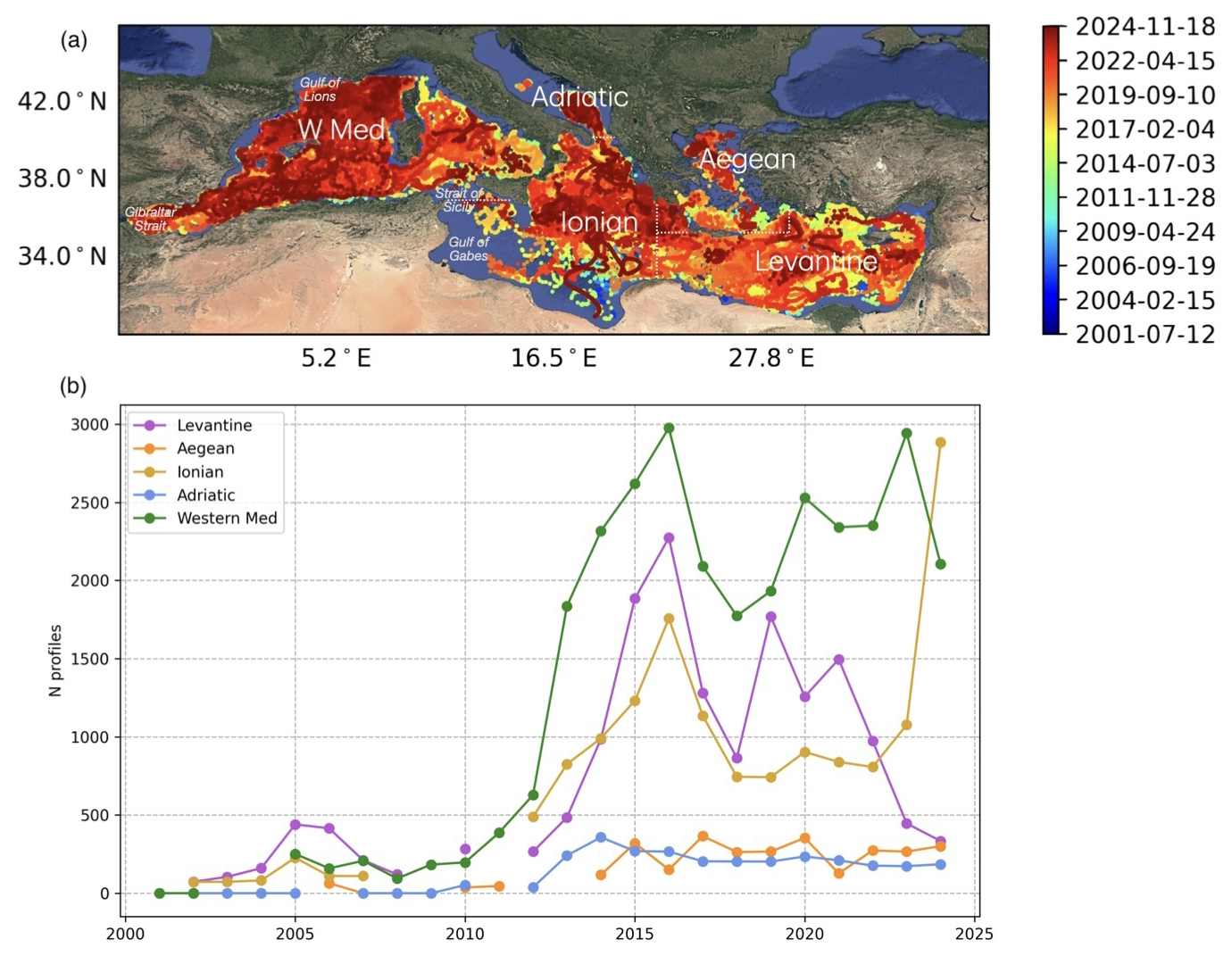
Figure 1(a) The Mediterranean Sea geography, with a colour-coded time span of the Argo profiles used in the research and marked regions over which the analyses have been carried out: the Adriatic Sea, the Ionian Sea, the Aegean Sea, the Levantine basin, and the western Mediterranean (image background from © Google Maps). (b) The annual number of Argo profiles per basin.
2.1 Argo float and atmospheric data
For this analysis, Argo profiling floats were downloaded for the entire Mediterranean Sea since their first deployments more than 2 decades ago (Fig. 1a). Data were downloaded through the argopy data fetcher (https://pypi.org/project/argopy/, last access: 17 July 2025) that was last accessed on 18 November 2024. The temporal range of the profiles is between 12 July 2001 and 18 November 2024. Only solid quality control (QC) profiles were chosen, i.e. delayed QC = 1 (“good”) and QC = 2 (“probably good”), but they were also in real-time mode in order to include profiles from floats that were still active. Of the 67 554 profiles in total, 64 809 profiles had QC = 1 (good) and only 2745 had QC = 2 (probably good), which form around 4 % of the entire dataset. A few additional conditions were set with the intention of discarding measurements that were not adequate for the analysis, despite the good QC flag. For example, the first measurement needed to be at a depth shallower than or equal to 10 m, as the analysis is primarily focused on surface layers. Moreover, the first depth quota had to be a positive number and all profiles needed to have measurements reaching at least 200 m. Only acquisitions in ascending mode were taken into consideration, and for the purpose of successful vertical gradient calculation (see the next section), an additional condition was set where profiles should have only increasing depth values without any vertical oscillations. Variables of temperature (T [°C]) and practical salinity (S [-]) were used, from which the potential density anomaly (PDA [kg m−3]) values were obtained with the use of TEOS-10 standards (https://www.teos-10.org, last access: 17 July 2025).
Total heat flux and its components (latent, sensible, shortwave, and longwave fluxes) averaged over the Levantine basin (latitude range 33–36° and longitude range 22–33°) were taken from the ERA5 hourly reanalysis (Hersbach et al., 2023) accessed on 4 April 2025. The 2024 daily flux anomalies were estimated with respect to the 2002–2024 daily averages.
2.2 Surface saline lake detection metrics
Surface saline lakes were calculated by setting a few conditions for each profile. SSLs' vertical salinity gradient SG was flagged when it reached a threshold value lower than or equal to SG m−1 within the first 200 m. The maximum depth reaching or exceeding the threshold was then defined as the depth of SG (zSG). Concomitantly, values of temperature (TG) and density (DG) gradients were also stored. Additionally, the Schmidt stability index (SSI) was obtained as a proxy for the water column stratification based on the approach in Duka et al. (2021), with the sole difference that the surface areas were not taken into consideration since we dealt with profiles and not surface areas. Therefore, for the scope of this work, the equation was modified accordingly as
where g is the gravitational acceleration (m s−2), zi is the depth at the ith point (m), zg is the depth between the surface and zSG offset by 5 m (m), ρz is the mean density at depth z (kg m−3), ρg is the mean density at zg, and Δzi is the depth between the ith and i+1th layers.
Saline lakes needed to meet a few further conditions. For example, salinity at the base of the saline lake had to be lower than the salinity value at the depth closest to the surface for at least 0.05 in order to avoid SSLs with low surface salinity coming, e.g., from river plumes. In order to reach statistically representative data in temporal terms, certain criteria needed to be met. Firstly, the number of profiles in a year must have been >1 % of the total number of profiles in the whole period for each of the selected regions shown in Fig. 1a. Secondly, the number of profiles in each month of every year needed to be greater than 2 % of the total number of profiles in that year. These percentages were chosen arbitrarily, trying to balance the length of the time series and the availability of enough data for analyses in a particular year or month. The annual number of profiles for each of the selected regions is shown in Fig. 1b.
3.1 Upper-layer climatology
Spatially, the collected Argo data were classified into five Mediterranean subregions as shown in Fig. 1a: the western Mediterranean; the Adriatic, Ionian, and Aegean seas; and the Levantine basin. Climatological median profiles of the upper 200 m of each of the locations, along with their 10th and 90th percentiles, can be seen in Fig. 2. Median temperature profiles range between 18–20 °C at the surface and around 14–16 °C at 200 m; the lowest values are found in the Adriatic Sea and the highest values in the Levantine basin. The 90th percentile reaches up to 26 and 27 °C at the surface in all of the basins and 14.5 and 17 °C at 200 m in the western Mediterranean and Levantine basin, respectively. The shallowest thermocline is present in the Adriatic Sea, presumably as the majority of floats are captured in the quasi-permanent cyclonic Southern Adriatic Gyre where upwelling is also persistent (Shabrang et al., 2016), while a subsurface temperature maximum can be detected in the Levantine basin. The median salinity profile exhibits the highest values in the first 50 m of the Levantine basin, with values above 39.0 and more than 39.2 at the surface (90th percentile above 39.5). The spatially aggregated profile's vertical shape (median and percentiles alike) exhibits a typical surface saline lake profile, thereby signifying its ubiquitous presence in the Levantine basin throughout the entire year. The Aegean Sea displays a vertical quasi-constant median value at around 39.1. This similarly also holds for the Adriatic Sea, although it has lower median salinity values, between 38.8 and 38.9, and exhibits a weak (sub)surface salinity minimum. The Ionian Sea and the western Mediterranean show a different vertical pattern, with salinity values increasing with depth and exhibiting the stronger influence of the Atlantic Water at the surface (Fedele et al., 2022). Median values for the Ionian Sea range between 38.7 at the surface and 39.0 at the bottom and between 37.8 and 38.5 in the western Mediterranean. Maximum surface median PDA values are seen in the Adriatic Sea and the Levantine basin, respectively, i.e. 28.1 and 27.9 kg m−3, with values reaching 29.0 kg m−3 at 200 m for all of the basins. The 90th percentile at the surface ranges between 28.6 and 29.1 kg m−3 for the western Mediterranean and Adriatic Sea, respectively.
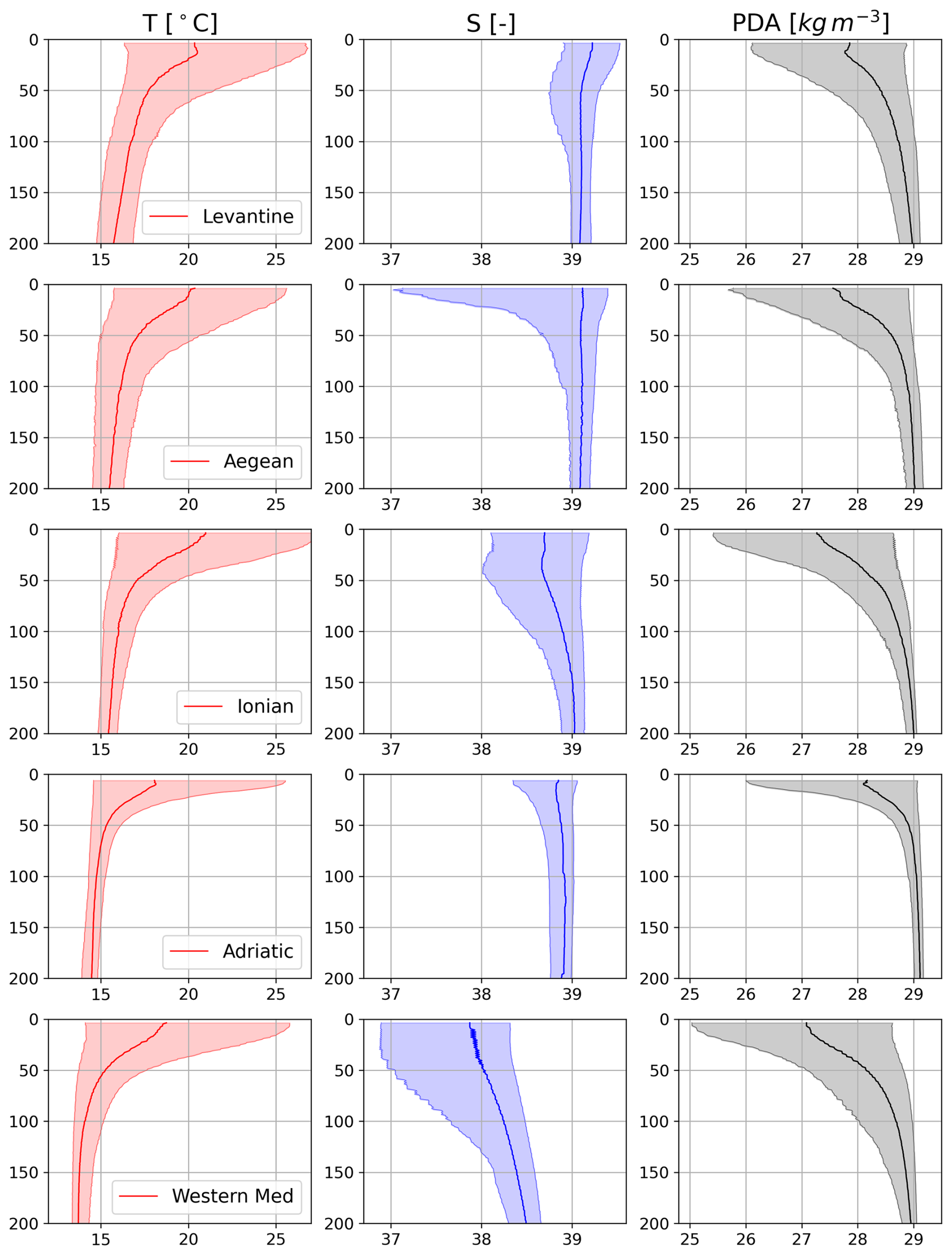
Figure 2Median values with the 10th and 90th percentiles for T, S, and PDA (columns) per basin (rows).
3.2 Case studies of surface saline lakes
As an example of the temporal evolution of thermohaline properties in the Levantine basin, a Hovmöller diagram for the long-term active WMO 6903269 float is shown in Fig. 3, along with its spatial trajectory colour-coded in time (between September 2019 and October 2024). The surface salinities for the first 3 years are seen to have a seasonal variability with increasing values during early summer lasting until winter, when surface values are lower than at intermediate depths. The appearance of a surface salinity maximum is always in late spring, lagging for 1 or 2 months after the generation of a strong seasonal thermocline. The depths of both the thermocline and halocline progressively deepened from approximately 10–20 m at their appearance to 100 m before exhibiting some vertical mixing in winter, while salinity may exceed 39.3 at the surface. Below the halocline, waters with lower salinity (around or below 39.0) can be found, indicating remnants of Atlantic Water that may be tracked even to these furthest sections of the Levantine basin (Fach et al., 2021; Zodiatis et al., 2023). Further below, a secondary salinity maximum can be found fluctuating between 100 and 300 m, indicating LIW generated in previous winters and spreading horizontally over the basin (Kubin et al., 2019). Since mid-2022, however, there has been a persistent SSL-like feature without any significant convective mixing or water column erosion that would bring surface values down to or lower than intermediate depths. Further, the subsurface salinity minimum is quite weak or non-existent. This is especially seen in the late winter and early spring of 2024, when the temperature, salinity, and PDA are more or less constant during the vertical mixing phase up to 300 m depth, i.e. T=19 °C, S=39.3, and PDA = 28.3 kg m−3. Indeed, the 2024 vertical mixing was stronger and reached deeper layers than during previous years, as shown in Fig. 4. Looking at daily anomalies for the winter of 2024, negative values are dominant in January and at the beginning of February, thus implying surface cooling that in turn causes vertical convection to occur.
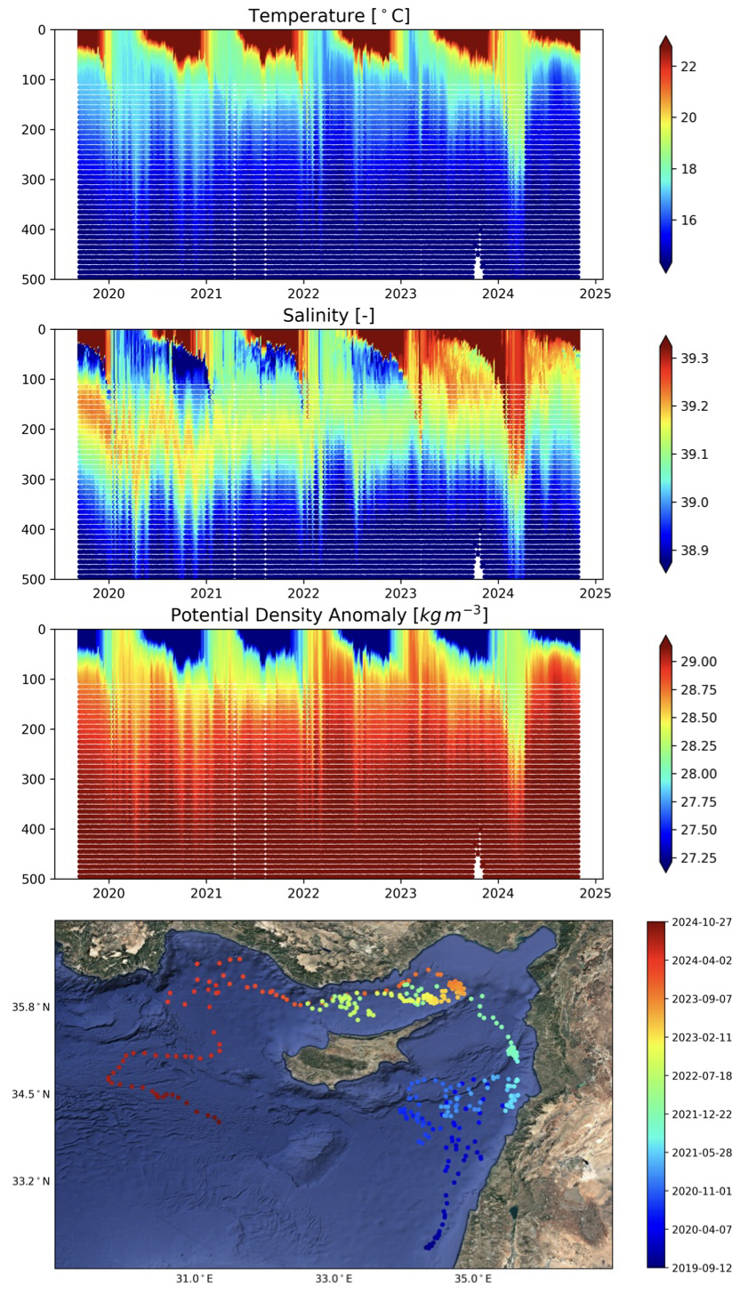
Figure 3Hovmöller diagram of T, S, and PDA for WMO 6903269 in the Levantine basin (white dots and lines are due to gaps in the dataset), with its trajectory shown at the bottom (image background from © Google Maps).
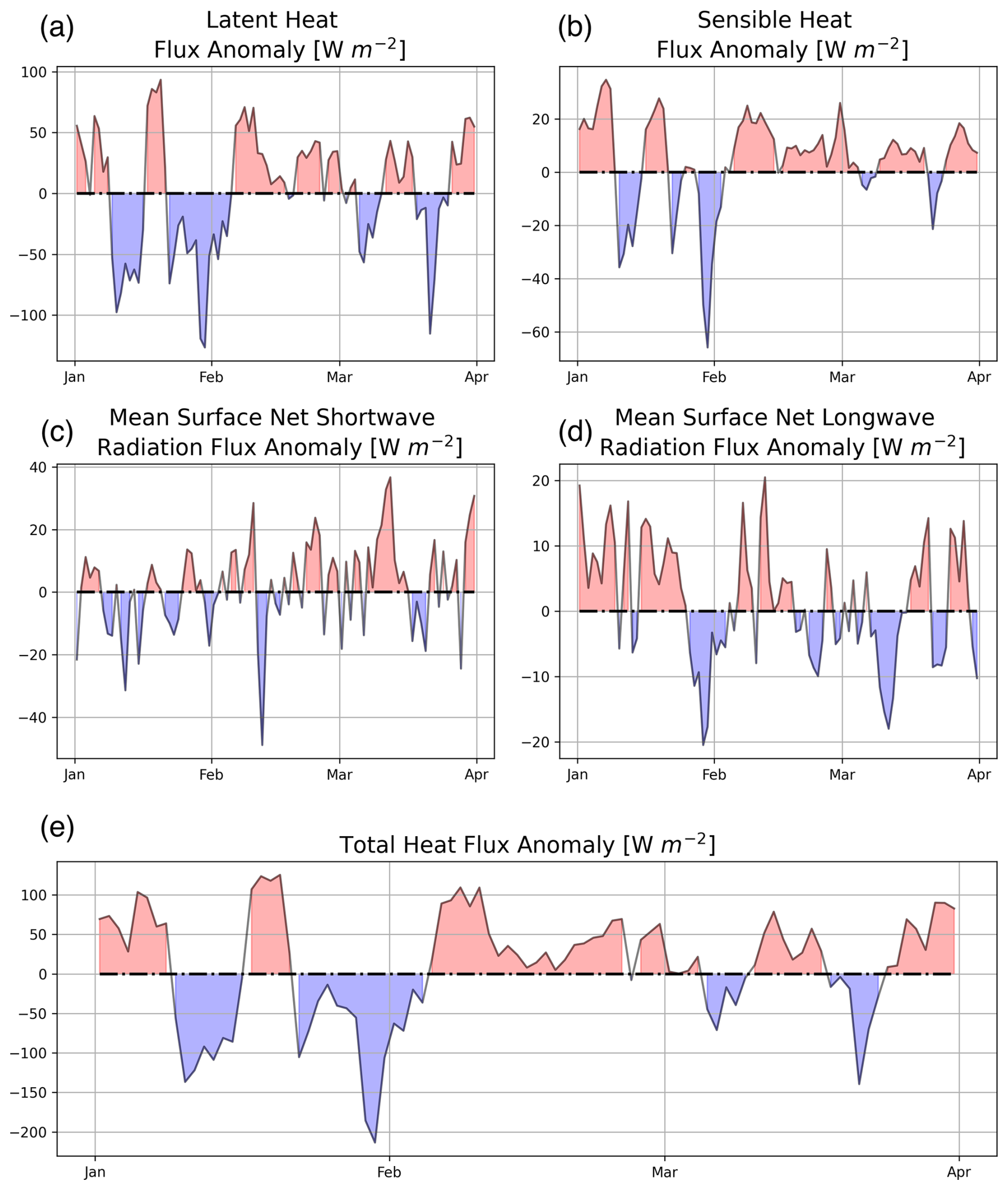
Figure 4Daily ERA5 heat flux anomalies between 1 January and 1 April 2024 averaged over the Levantine basin with respect to the 2002–2024 climatology: (a) latent, (b) sensible, (c) net shortwave, and (d) net longwave components and (e) the total sum.
Examples of T, S, and PDA profiles with their vertical gradients for different SSL cases are shown in Fig. 5. Autumn profiles in the Levantine basin (WMO 6901897, sampling date 28 November 2014) and western Mediterranean (WMO 6903820, sampling date 15 October 2024) in Fig. 5a and b show deeper and more pronounced vertical salinity gradients. SG values reach less than −0.04 m−1 in both cases, with TG values of approximately −0.3 and −0.6 °C m−1 and DG values of 0.04 and 0.13 kg m−4 at the zSG depths of 75.0 and 39.6 m, respectively. Both examples are shown for a period after months of extensive evaporation and water column stabilization during summer. However, the major difference between these two profiles is in the overall salinity values. That is, the Levantine basin SSL has an approximately 0.8 higher salinity than the western Mediterranean one. The lower limits of saline lake detection are seen in Fig. 5c for the Ionian Sea example (WMO 6990629, sampling date 2 June 2024) in late spring, when the lakes can start forming during the water column stabilization due to the existence of a strong thermocline and increased evaporation (SG value of −0.011 m−1, barely reaching the threshold value, at a depth of 19.8 m). The Adriatic Sea example shown in Fig. 5d exhibits a shallow but strong gradient in late summer (WMO 6903799, sampling date 17 August 2023), reaching SG, TG, and DG values of up to −0.04 m−1, less than −0.8 °C m−1, and more than 0.2 kg m−4, respectively, at a depth shallower than 15 m, with surface values exceeding 39.2 in accordance with findings by Mihanović et al. (2021).
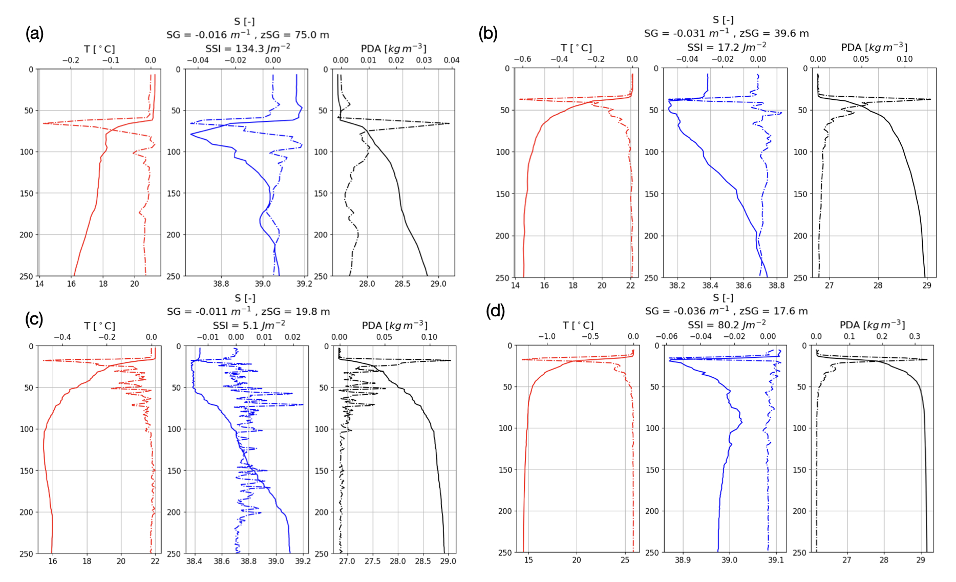
Figure 5Examples of vertical T, S, and PDA profiles (full lines) and their vertical rates of change (dashed lines) at which a surface saline lake is detected: (a) the Levantine basin (float number 6901897, profile sampled on 28 November 2014), (b) the western Mediterranean (float number 6903820, profile sampled on 15 October 2024), (c) the Ionian Sea (float number 6990629, sampled on 2 July 2024), and (d) the Adriatic Sea (float number 6903799, sampled on 17 August 2023).
3.3 Surface saline lake climatology
A spatial gradient can be seen in the distribution of SSLs, increasing in percentage towards the east (Fig. 6). In the eastern Mediterranean (the Levantine and Aegean seas), SSLs are present throughout the entire year, with the highest percentage in the Levantine basin (up to 72 % in October). On the other hand, SSLs are reduced in numbers after convective mixing during winter and early spring, or they completely disappear in the western Mediterranean, where the highest percentage does not reach a number higher than 35 % in September. Overall, the highest percentage is seen in the late summer and early autumn months after having reached a longer period of stable stratification and enhanced evaporation, peaking in September and October for most of the basins. The percentage of SSLs is in general highest in the easternmost region – the Levantine basin with above 40 % from June to December, followed by the Adriatic, Ionian, and Aegean seas and the western Mediterranean.
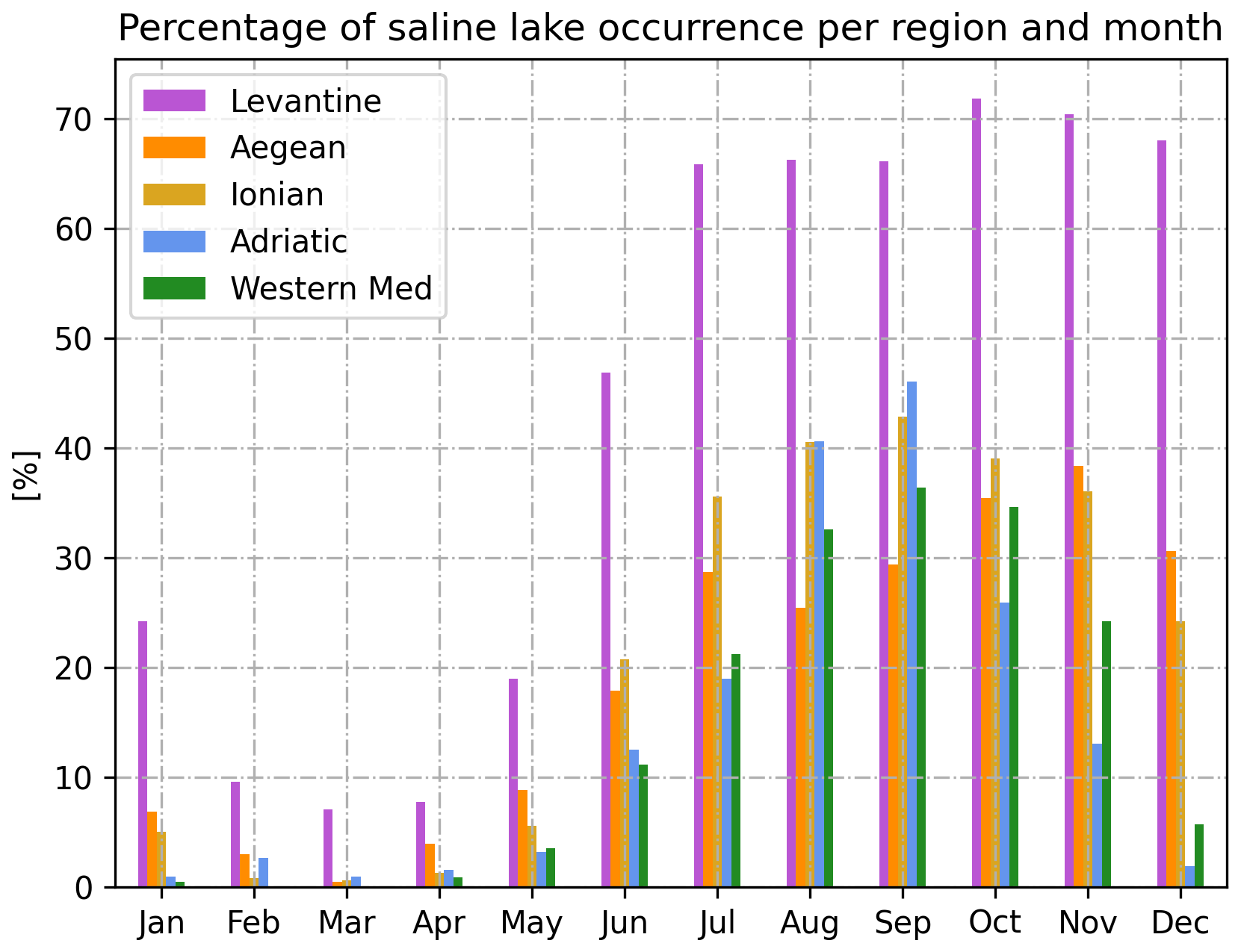
Figure 6Percentages of profiles in which surface saline lakes occur for all months and basins.
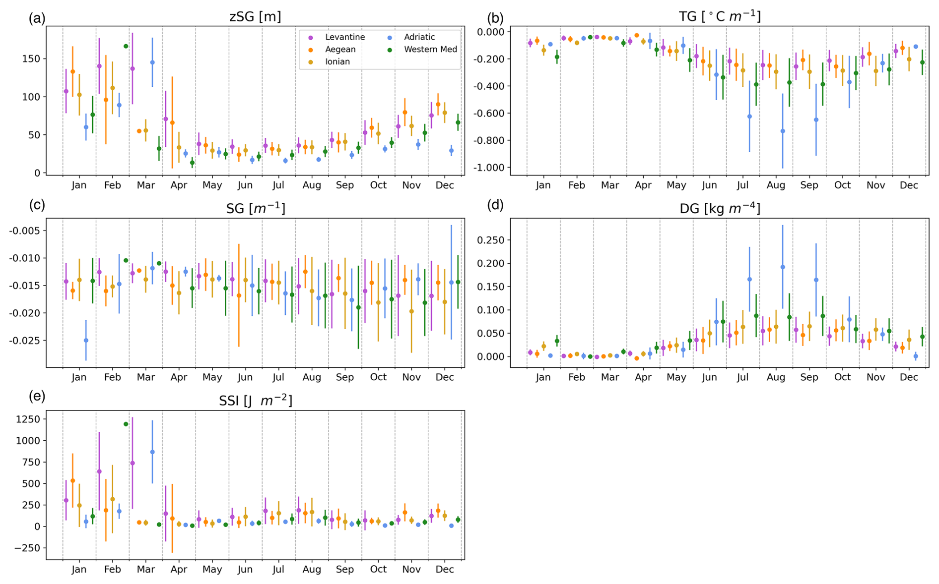
Figure 7Monthly median and interquartile ranges (25th and 75th percentiles) of (a) the depth of surface saline lakes zSG, the respective (b) TG, (c) SG, and (d) DG at the base of the lake, and (e) the SSI of the lake over the selected regions.
The monthly climatology of surface saline lake depth, zSG, displays the overall lowest values in the Adriatic Sea (except in March) and the western Mediterranean (except in February), while the deepest gradient locations are found in the Levantine basin and the Aegean Sea (Fig. 7a). Both TG and DG exhibit stronger seasonal variability, clearly showing the temperature's influence in determining density in the surface layers. Minimum (maximum) values of TG (DG) can be seen in the Adriatic Sea (between July and September, Fig. 7b and d), denoting shallow but intense accumulation of heat near the surface. Monthly median TG values range between close to zero and −0.04 °C m−1 during summer, reaching peaks in the Adriatic below −0.6 or even −0.8 °C m−1, whereas DG values are up to 0.1 and 0.2 kg m−4 in the Adriatic. The SSI shows the greatest values during the winter months, similar to zSG, i.e. up to 1200 J m−2 (Fig. 7e). This might be due to the index's sensitivity to low surface PDA values in the western Mediterranean, which could be caused by an enhanced influence of fresher Atlantic Water. SG, on the other hand, does not show any seasonal variability, with median values ranging between −0.018 and −0.013 m−1, except for the Adriatic Sea value in January (Fig. 7d), but this is based on a limited number of SSLs. The high SSI during winter in the Levantine basin coincides with the greatest zSG, thereby showing that certain profiles are not fully eroded during winter cooling and convection but just stretch SSLs towards greater depths (Fig. 7e). On the other hand, in the period between September and December, an increase in zSG is not followed by an increase in the SSI. Hence, even though an increase in zSG could be present, the density decrease and changes within a SSL could be the prevailing mechanism for these particular months, which could be due to a higher precipitation rate, riverine discharge, or advection of water masses, all of which can cause lower SSI values. The overall median ranges for the individual basins are from −0.21 °C m−1 (Levantine) to −0.46 °C m−1 (Adriatic) for TG, from 0.04 kg m−4 (Levantine) to 0.11 kg m−4 (Adriatic) for DG, and from 31.6 J m−2 (Adriatic) to 100 J m−2 (Ionian) for the SSI.
Probability density functions (PDFs) for each of the SSL detection and description parameters per region can be seen in Fig. 8. zSG peaks at 20 m in the Adriatic Sea, 35 m in the western Mediterranean, and around 45 m in the other basins. The widest spread is in the Aegean Sea, with high PDF values to depths of approximately 75 m. This might indicate a difference in SSLs between the northern and southern Aegean Sea, as the profiles are quite rare in the separation area in the central Aegean Sea that contains a number of islands (Fig. 1a). Unlike zSG, TG displays the widest spread of PDFs in the Adriatic Sea (Fig. 8), and its shape differs substantially compared to the other basins, showing a more evenly distributed range of values. In all of the basins, the peaks are slightly lower than or around −0.1 °C m−1. In terms of SG, the PDFs do not differ much from basin to basin, all of them peaking near −0.015 m−1 and having a relatively narrow distribution range. As seen in Fig. 7, DG is more influenced by TG, and hence the PDF is also more variable between the regions, with the Adriatic Sea again having a much wider spread and a flatter peak. This is followed by the western Mediterranean, whereas the Levantine basin and the Ionian and Aegean seas all peak around 0.02 kg m−4 and have a very similar distribution shape. The SSI shows the flattest distribution range for the Aegean Sea, followed by the western Mediterranean. The Adriatic and Ionian seas display the most similar curves, with the Ionian region peaking at higher SSI values compared to the former. The narrowest PDF is observed for the Levantine basin.
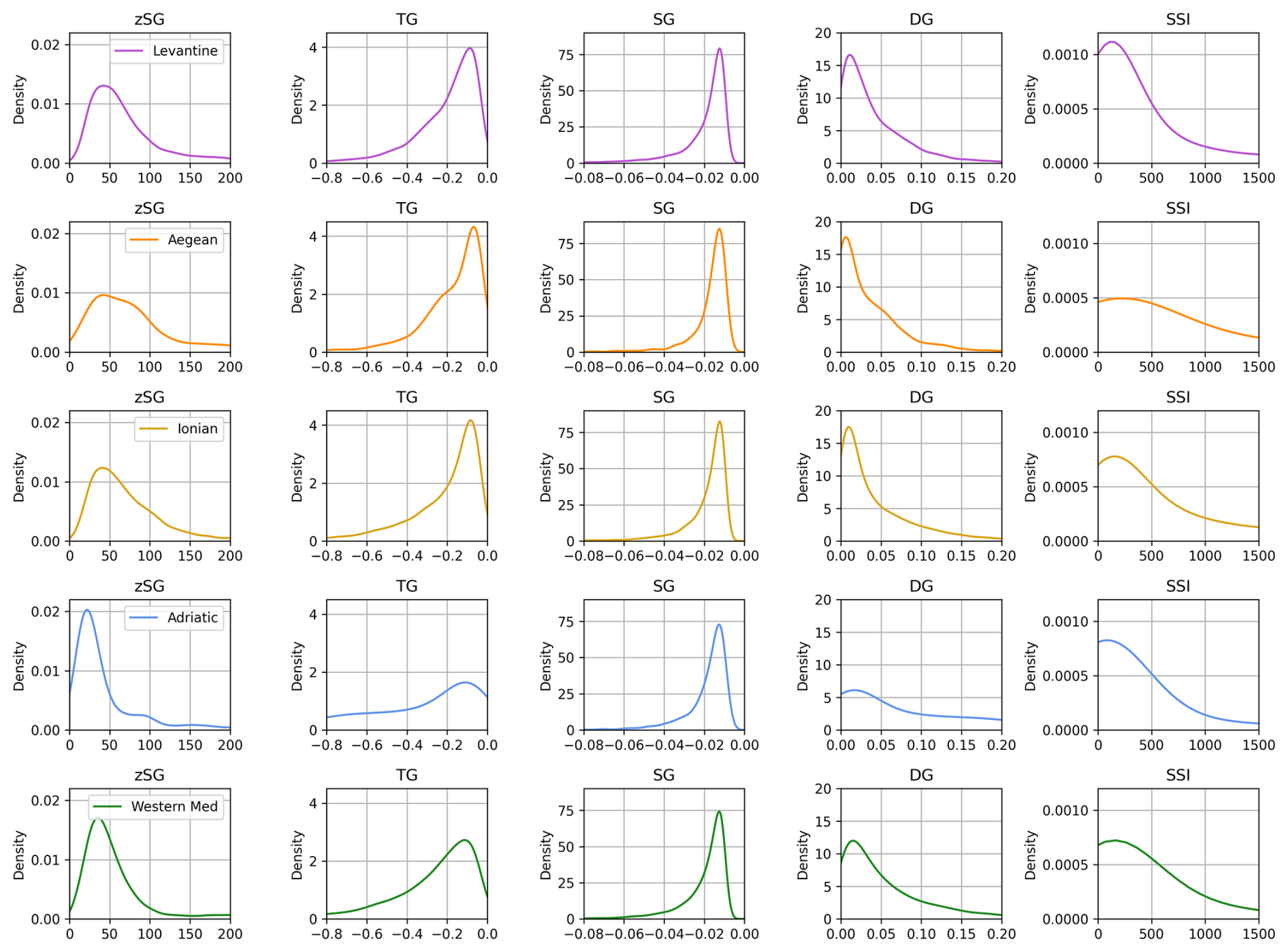
Figure 8Probability density functions for zSG, TG, SG, DG, and the SSI (columns) of a lake over the selected regions (rows).
3.4 Interannual variability and trends
The monthly median time series exhibit high variability between the basins (Fig. 9). The Adriatic Sea displays the overall lowest (highest) TG (DG) and zSG values, most notably so since 2015, with a continuous decrease (increase) in TG (DG) with time up to the present. The Levantine basin and the Aegean and Adriatic seas show a deepening of zSG since 2015, highlighting a drastic jump between 2014 and 2015 (with the maximum values increasing from 90 to 175 m for the Levantine basin). This shift is concomitant with an increase in the SSI, also peaking between 2015 and 2021, after which the values return to the previous range or a slightly higher range of values up to the present.
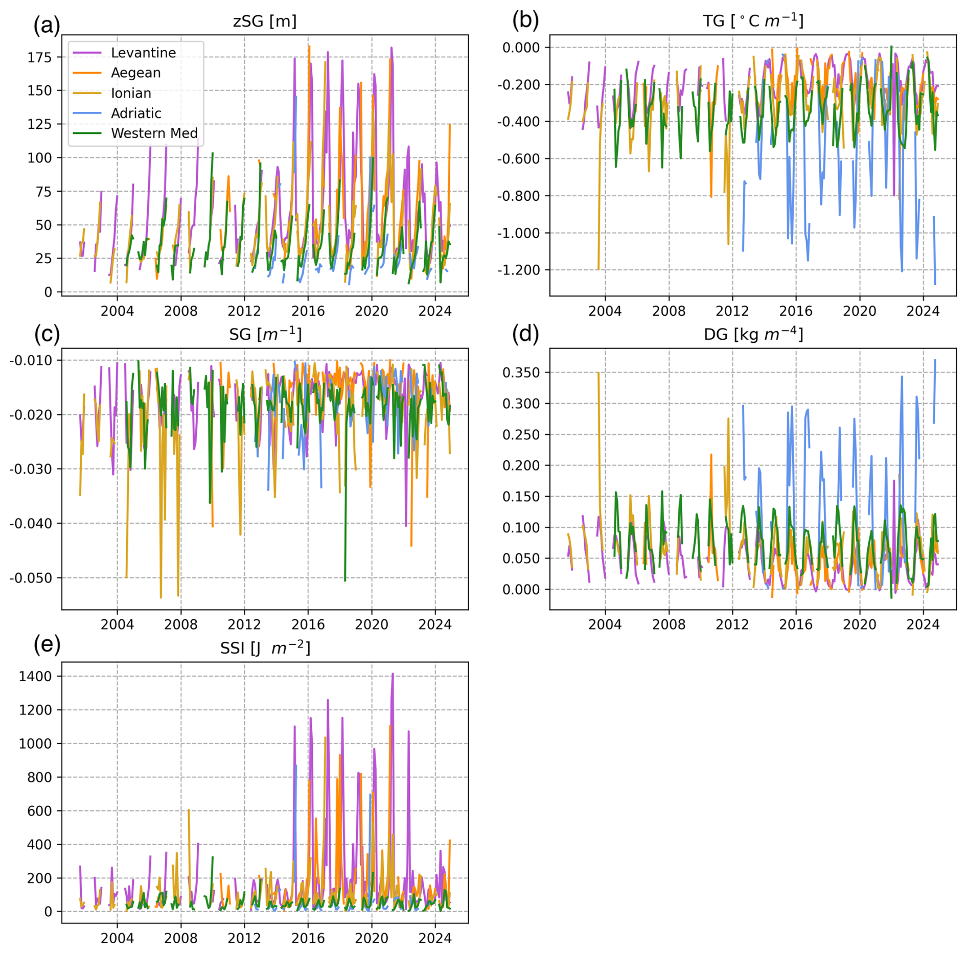
Figure 9Monthly median time series of (a) the depth of the surface saline lake zSG, the respective (b) TG, (c) SG, and (d) DG at the base of the lake, and (e) the SSI of the lake over the selected regions.
Due to temporal gaps when looking at each region separately, trends were obtained for the whole Mediterranean Sea (Fig. 10). The seasonal signal was removed with annual and semi-annual cosine function fits. The results reveal a deepening of SSLs in time, with zSG increasing by around 1 m yr−1. Vertical gradients of thermohaline properties all exhibit a decreasing trend: SG around 0.0002 m−1 yr−1, TG = 0.0045 °C m−1 yr−1, and DG = 0.0013 kg m−4 yr−1 (Fig. 10). The SSI has a statistically insignificant increasing trend (p>0.01) of 4.81 J m−2 yr−1, with an interannual dynamic like the one documented for zSG.
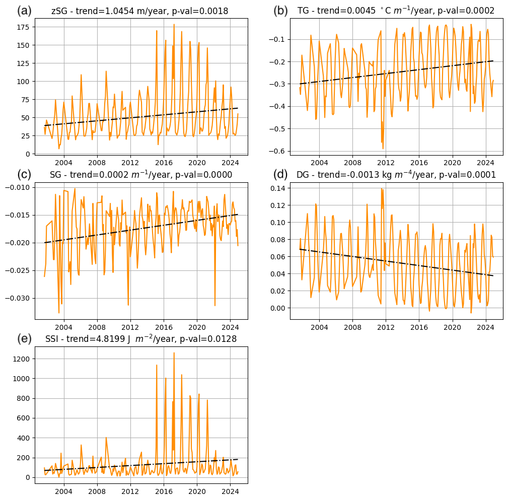
Figure 10Linear trends of (a) the depth of the surface saline lake zSG, the respective (b) TG, (c) SG, and (d) DG at the base of the lake, and (e) the SSI of the lake.
3.5 Surface saline lake spatial extent
Given the way Argo floats measure profiles point by point, it is difficult to give a detailed assessment of the spatial extent over which SSLs are present. However, it is possible to give a rough idea by analysing the spatial maps of all float trajectories for certain months, as shown in Fig. 11. Four maps were selected for 2 different years, 2016 and 2021, and for 2 different months for each of the examined years: 1 when we have few SSLs (April, Fig. 11a and c) and the other when we have the highest percentage of SSLs overall (September and October, Fig. 11b and d). Blue dots show profiles where we do not have SSLs, whereas red dots are the ones with SSLs for that specific month and year. The April months of 2016 and 2021 display separate and spatially isolated cases of SSLs both east and west, seldom being a part of a series of float samplings, as they only start to emerge with the water column stratification (unless they are deep enough to have resisted the winter convective mixing). Looking at the two figures in September 2016 and October 2021, there is clearly a wider spatial extent and a series of samplings that all correspond to SSLs. Hence, there is also a wider spatial distribution, often resulting in longer trajectories.
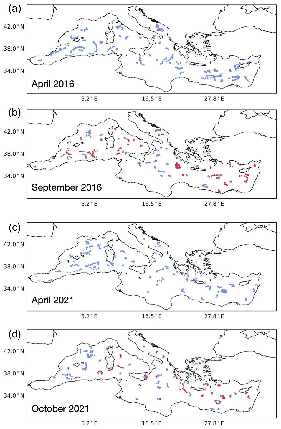
Figure 11Examples of the spatial extent of SSLs over a certain month for (a) April 2016, (b) September 2016, (c) April 2021, and (d) October 2021. The blue dots denote profiles without SSLs, whereas the red ones highlight profiles with SSLs.
For the first time, an objective analysis of in situ ocean data indicates that the accumulation of salt near the sea surface during strong heating, evaporation, and low-mixing seasons is present in the whole of the Mediterranean Sea. Inside the Mediterranean itself, such salinity profiles have so far been seen substantially only in the Levantine basin (Manca et al., 2004; Ozer et al., 2020; Kubin et al., 2019), while some case studies document their occasional existence in the Adriatic Sea (Mihanović et al., 2021). The accumulation shows some common characteristics (e.g. halocline strength) and some differences (e.g. the overall temperature and salinity) between the different Mediterranean basins. Their widespread presence in different regions inside the Mediterranean suggests that processes (such as wintertime mixing and double diffusivity) that transport surface salt to intermediate depths, previously limited only to the Levantine basin and the Adriatic Sea (Amorim et al., 2024), exist elsewhere.
Results have shown a high seasonal and spatial variability of surface salt accumulation but also interannual variations that resulted in small but statistically significant trends. A west-to-east spatial gradient in both the depth and frequency of SSLs may be explained by the differences in atmospheric patterns as well as general surface salinity values. The western Mediterranean is less saline due to its proximity to the Atlantic and therefore stronger effects of less saline Atlantic waters, together with a higher precipitation rate, higher riverine discharge, and lower evaporation. The eastern Mediterranean (except for the Adriatic Sea) is more arid with less freshwater discharge, getting some freshwater input through the Nile delta, but it is generally a region with much less precipitation, higher evaporation, and less wintertime mixing (Ulbrich et al., 2012), all contributing to higher surface salinities.
In terms of interannual variability, the drastic increase in certain properties that define the SSLs (such as zSG and the SSI) since 2015 could highlight a change in the atmospheric forcings in recent years, as was seen for the heat fluxes in the Levantine basin in 2024. However, the results could be biased due to spatiotemporal variable float sampling and the varying annual number of floats. As shown in Fig. 1b, the annual number of floats increased drastically from 2013 onward, but the “jump” seen in Fig. 9a, d, and e only appeared from 2015. The explanation that the results might not be biased due to varying sampling rates and profile numbers could be argued further when looking at the case of the Ionian Sea (light-brown line in Fig. 1b), where the steep increase in the number of profiles in 2024 does not result in an increase in zSG or the SSI as in 2015 in the Levantine and Adriatic seas or a similar subsequent increase in the Aegean Sea in 2016. The western Mediterranean does not have any such changes. Hence it is a question of whether this is the result of localized changes in the eastern Mediterranean basins, where trends in both warming and salinification have been increasing rapidly in recent decades (Aydogdu et al., 2023). For example, this has also been seen in the Cretan Sea, especially since 2017 (Chiggiato et al., 2023). During the last salinification phase since 2017, the high-salinity increase extended down to depths below the intermediate layer, and it is not yet clear which implications it might have had or will have in the following years. Consequences have been felt in the southern Adriatic too, facilitating diffusivity of more saline waters originating from the Levantine basin towards the bottom of the pit (Mihanović et al., 2021; Amorim et al., 2024).
In the regional climate projections, net heat loss is expected to decrease (Soto-Navarro et al., 2020) due to an increase in shortwave, net longwave, and sensible heat loss (Dubois et al., 2012). This could have already started, resulting in a weakened convection that was unable to efficiently mix the water column, as seen in the Hovmöller diagram in Fig. 3 for the Levantine basin. Enhanced evaporation and reduced precipitation may both contribute to higher surface salinities, thus requiring more energy for efficient vertical mixing. This has already been demonstrated as a trend in the Mediterranean Sea (Skliris et al., 2018), and it is also expected to continue in the future (Soto-Navarro et al., 2020). In combination with reduced convective mixing, such features could persist over the entire year without being eroded from one winter season to the next, as is already the case in subtropical gyres in the Atlantic and Pacific oceans (Melzer and Subrahmanyam, 2017); this will be explained further below.
SSLs might therefore serve as an additional indicator of climate change given the fact that an increased stratification (and hence less intense mixing) is to be expected in the future as one of the consequences of continuous warming. According to the Special Report on the Ocean and Cryosphere in a Changing Climate (IPCC, 2022), the global stratification increased in 1998–2019 compared to 1979–1990 by around 2.3 % and might increase by up to 12 %–30 % compared to the 1985–2005 reference period at the end of the 21st century (2081–2100) in the case of the business-as-usual RCP8.5 scenario. Globally, Cheng et al. (2020) estimated an accelerating increase in average salinity since the 1960s for the first 2000 m (2 %–4 % per degree Celsius of warming). Salinity variations can thus sensitively reflect the net exchange of freshwater between the ocean and the atmosphere. Similar mechanisms were observed in the Adriatic Sea, as demonstrated in Mihanović et al. (2021): after the thermocline formation, the halocline appears after a few months due to the evaporation of a shallow surface layer. The higher the warming rate, the greater the thermocline and hence the higher the evaporation rate, which as a result causes higher surface salinities.
The Mediterranean Sea is quite unusual due to its exceptionally high surface salinities. In the case of a global salinification trend, changes in the region may potentially provide a clue about the possible changed thermohaline dynamics in other parts of the world and could thus justify its being denoted as a laboratory region. The question remains whether the currently periodic SSLs may become a (quasi-)permanent feature in the absence of strong winds that could erode the vertical profile.
Outside the Mediterranean Sea, surface saline lakes may be (quasi-)permanent features that are also present all year round in subtropical high-atmospheric-pressure zones with high evaporation, low precipitation, and low vertical mixing induced by winds. Such cases are present in both the Atlantic and Pacific oceans. For example, two float trajectories in the North Pacific (WMO 4903503, https://fleetmonitoring.euro-argo.eu/float/4903503, last access: 17 July 2025) and South Pacific subtropical gyres (WMO 5905261 https://fleetmonitoring.euro-argo.eu/float/5905261, last access: 17 July 2025), regions of North and South Pacific high-pressure systems, both exhibit SSLs as a permanent feature with stable layers of higher (sub)surface salinities. They reach less than 100 m in the southern gyre and more than 200 m in the northern gyre, albeit with maximum salinities that do not exceed 35.3 in the north and 36.4 in the south. The Atlantic may be partially influenced by the intrusion of highly saline waters through the Mediterranean Outflow, which causes it to be saltier compared to the Pacific, although the impact it has on the overall higher salinity of the Atlantic compared to the Pacific has been questioned (Jones and Cessi, 2017). A float in the Northern Atlantic Subtropical Gyre, a region of the Azores high-pressure system (WMO 4903739, https://fleetmonitoring.euro-argo.eu/float/4903739, last access: 17 July 2025), upon travelling southward, has surface salinity increases to values of up to 36.2, exhibiting a permanent and stable layer of higher subsurface salinities. Similarly, in the South Atlantic, the region of the St. Helena High (WMO 6904187, https://fleetmonitoring.euro-argo.eu/float/6904187, last access: 17 July 2025), surface salinity reaches up to 36.6, with a SSL shape that is stable throughout the entire sampling period. Clearly, no seasonality is seen in such regions, and SSLs persist as a stable, constant feature without being eroded. This is the major difference from the current climate of SSLs in the Mediterranean, which are still eroded in the majority of the basin during wintertime mixing and therefore contribute to the generation of intermediate and deep waters and their ventilation.
This method could in principle be extended to other regions. However, it should be noted that the salinities in question in the Mediterranean Sea exceed the ones in the other regions by up to 3 or even 4. The maximum salinities in the Pacific cases were between 35.3 and 36.4, whereas the values in the eastern Mediterranean, as well as exceptionally in the Adriatic Sea, may even reach 39.4–39.5, as shown in Figs. 2 and 3. This is an important difference, showing that, even though SSLs might be present in other regions, their sheer existence is not a sufficient condition for potential sinking and dense water formation, as in the Mediterranean. Still, this might eventually change (at a certain level, presumably not like in the Mediterranean) in oceans in the future climate, as subtropical high systems are also projected to change in space, time, and intensity (Cherchi et al., 2018).
Linear trends from a time series built from the Mediterranean Argo data after the seasonal signal removal exhibit weakening vertical gradients of temperature, salinity, and PDA while at the same time showing a deepening of the SSLs (increasing zSG). This could also be an indicator that the water mass under the SSL is getting saltier and warmer, thus weakening the gradients and enabling easier expansion of SSLs. One such example has already been documented and described in Schroeder et al. (2017), where LIW was shown to become both warmer and saltier in the Strait of Sicily at intermediate depths.
Finally, SSLs could for all of these reasons be a possible indicator of changing biogeochemical properties and therefore may affect marine life. The first strong appearance of SSLs in the Adriatic in 2017 (Beg Paklar et al., 2020) substantially changed the microbial food web, e.g. redirecting the abundance of heterotrophic bacteria for several standard deviations from the average values and changing the composition rates between Prochlorococcus, Synechococcus, and picoeukaryotes. Salinization of the eastern Mediterranean and southern Adriatic already resulted in a feedback mechanism which completely switched the oxygen content dynamics in the northern Ionian Sea (Martellucci et al., 2024) between different phases of the Adriatic-Ionian Bimodal Oscillating System known – at least at present – to drive Adriatic thermohaline and biogeochemical properties (Gačić et al., 2010; Civitarese et al., 2010, 2023; Batistić et al., 2014). In the Mediterranean and globally, projected changes in stratification would decrease dissolved oxygen and primary production (Doney et al., 2014; Richon et al., 2019; Lachkar et al., 2024), undoubtedly with strong effects propagating the signal through the food web. Surface saline lakes might be one mechanism fostering such changes.
In this work we introduced a robust and objective algorithm for the detection of upper-layer profiles in different Mediterranean basins characterized by a quasi-constant maximum in salinity above the pycnocline, referred to as surface saline lakes (SSLs). This phenomenon has been known to occur regularly in the Levantine basin and is sporadically documented for some others like the Adriatic Sea. First, we showed different examples of vertical profiles where SSLs were spotted, varying in gradient strength and depth. The climatological analysis showed the highest SSL percentage and the maximum depth in the eastern Mediterranean, especially the Levantine basin. Minimum occurrences were seen between February and April, with peaks between August and October.
Lakes were present throughout the entire year in the eastern Mediterranean, whereas in the western Mediterranean they disappeared in late autumn or early winter, most likely due to the convective erosion of the water column. These findings underscore the role of atmospheric heat and water exchange in all Mediterranean basins, influencing deeper thermohaline properties through winter mixing.
SSLs were detected in all of the Mediterranean basins, with the highest prevalence in the Levantine region, i.e. with 65 %–70 % of the profiles between July and December. During the August–October peak, SSLs exceeded 35 % of the monthly profiles in each basin, even in the western Mediterranean, albeit with varying overall salinity levels and variable SSL ranges. By looking at the monthly climatologies of the various SSL definition parameters, a small range of variability was observed in salinity gradients at the SSL base, unlike for temperature and density gradients, with the latter seemingly influenced more by temperature than by salinity. SSL depth monthly values ranged from 25 m during the spring and summer months to up to 175 m in late winter, consistent with high SSI values, showing that certain SSLs are deep enough to not be eroded by winter convection.
Despite pronounced interannual and seasonal variability, our analysis of the data showed a significant trend in SSL depth, accompanied by decreasing thermohaline gradients (temperature, salinity, and PDA) at SSL bases through the investigated period. However, these trends may partly reflect sampling biases due to time–space differences in Argo float coverage, which were substantial before 2013. The observed changes prompt questions about their underlying causes, as the observation period is still too short to derive any robust conclusions – whether they reflect ongoing climate-change-driven salinization and alterations in Mediterranean water mass dynamics or simply result from natural decadal variability. In any case, the SSLs may be an indicator of changes within the upper ocean where stratification is globally projected to occur, undoubtedly with substantial effects on biogeochemistry and marine life.
The codes are freely available upon request.
All data were downloaded through argopy – a Python library aimed at Argo data users: https://pypi.org/project/argopy/ (argopy, 2025).
ET: formal analysis, methodology, investigation, data curation, writing – original draft, review, and editing. CG: formal analysis, investigation, data curation, writing – review and editing. IV: conceptualization, methodology, investigation, writing – original draft, review and editing, supervision, funding acquisition.
The contact author has declared that none of the authors has any competing interests.
Publisher's note: Copernicus Publications remains neutral with regard to jurisdictional claims made in the text, published maps, institutional affiliations, or any other geographical representation in this paper. While Copernicus Publications makes every effort to include appropriate place names, the final responsibility lies with the authors.
This article is part of the special issue “Special issue on ocean extremes (55th International Liège Colloquium)”. It is not associated with a conference.
We thank the European Argo data providers and developers for their great work in making the products and data used available for research. We would also like to thank the MapPlotter (https://pypi.org/project/MapPlotter/2.2.0/, last access: 17 July 2025) and Basins (https://pypi.org/project/Basins/, last access: 17 July 2025) library developers for their efforts in making helpful and visually appealing tools for data visualization and spatial division. Also, we are grateful to the argopy (https://pypi.org/project/argopy/, last access: 17 July 2025) library developers for making the Argo data analysis much easier and user-friendlier. The comments and suggestions raised by two anonymous reviewers are also greatly appreciated.
The research was supported by the Croatian Science Foundation through project GLOMETS (grant no. IP-2022-10-3064), an incoming mobility scheme for postdoctoral researchers (grant no. MOBDOL-2023-12, Elena Terzić), and the Interreg Italy–Croatia project AdriaClimPlus (grant no. ITHR0200333).
This paper was edited by Yonggang Liu and reviewed by Minghai Huang and Javier Soto-Navarro.
Aldama-Campino, A. and Döös, K.: Mediterranean overflow water in the North Atlantic and its multidecadal variability, Tellus A, 72, 1565027, https://doi.org/10.1080/16000870.2018.1565027, 2020. a
Amorim, F. L. L., Le Meur, J., Wirth, A., and Cardin, V.: Tipping of the double-diffusive regime in the southern Adriatic Pit in 2017 in connection with record high-salinity values, Ocean Sci., 20, 463–474, https://doi.org/10.5194/os-20-463-2024, 2024. a, b
argopy: argopy 1.2.0, https://pypi.org/project/argopy/ (last access: 18 July 2025), 2025. a
Ayache, M., Swingedouw, D., Colin, C., and Dutay, J.-C.: Evaluating the impact of Mediterranean overflow on the large-scale Atlantic Ocean circulation using neodymium isotopic composition, Palaeogeogr. Palaeocl. Palaeoecol., 570, 110359, https://doi.org/10.1016/j.palaeo.2021.110359, 2021. a
Aydogdu, A., Miraglio, P., Escudier, R., Clementi, E., and Masina, S.: The dynamical role of upper layer salinity in the Mediterranean Sea, State Planet, 1-osr7, 1–9, https://doi.org/10.5194/sp-1-osr7-6-2023, 2023. a, b
Batistić, M., Garić, R., and Molinero, J.: Interannual variations in Adriatic Sea zooplankton mirror shifts in circulation regimes in the Ionian Sea, Clim. Res., 61, 231–240, https://doi.org/10.3354/cr01248, 2014. a
Beg Paklar, G., Vilibić, I., Grbec, B., Matić, F., Mihanović, H., Džoić, T., Šantić, D., Šestanović, S., Šolić, M., Ivatek-Šahdan, S., and Kušpilić, G.: Record-breaking salinities in the middle Adriatic during summer 2017 and concurrent changes in the microbial food web, Prog. Oceanogr., 185, 102345, https://doi.org/10.1016/j.pocean.2020.102345, 2020. a
Borghini, M., Bryden, H., Schroeder, K., Sparnocchia, S., and Vetrano, A.: The Mediterranean is becoming saltier, Ocean Sci., 10, 693–700, https://doi.org/10.5194/os-10-693-2014, 2014. a
Cheng, L., Trenberth, K. E., Gruber, N., Abraham, J. P., Fasullo, J. T., Li, G., Mann, M. E., Zhao, X., and Zhu, J.: Improved Estimates of Changes in Upper Ocean Salinity and the Hydrological Cycle, J. Climate, 33, 10357–10381, https://doi.org/10.1175/JCLI-D-20-0366.1, 2020. a
Cherchi, A., Ambrizzi, T., Behera, S., Freitas, A. C. V., Morioka, Y., and Zhou, T.: The Response of Subtropical Highs to Climate Change, Curr. Clim. Change Rep., 4, 371–382, https://doi.org/10.1007/s40641-018-0114-1, 2018. a
Chiggiato, J., Artale, V., Durrieu de Madron, X., Schroeder, K., Taupier-Letage, I., Velaoras, D., and Vargas-Yáñez, M.: Chapter 9 - Recent changes in the Mediterranean Sea, in: Oceanography of the Mediterranean Sea, edited by: Schroeder, K. and Chiggiato, J., Elsevier, 289–334, ISBN 978-0-12-823692-5, https://doi.org/10.1016/B978-0-12-823692-5.00008-X, 2023. a
Civitarese, G., Gačić, M., Lipizer, M., and Eusebi Borzelli, G. L.: On the impact of the Bimodal Oscillating System (BiOS) on the biogeochemistry and biology of the Adriatic and Ionian Seas (Eastern Mediterranean), Biogeosciences, 7, 3987–3997, https://doi.org/10.5194/bg-7-3987-2010, 2010. a
Civitarese, G., Gčić, M., Batistić, M., Bensi, M., Cardin, V., Dulčić, J., Garić, R., and Menna, M.: The BiOS mechanism: History, theory, implications, Prog. Oceanogr., 216, 103056, https://doi.org/10.1016/j.pocean.2023.103056, 2023. a
Doney, S., Bopp, L., and Long, M.: Historical and Future Trends in Ocean Climate and Biogeochemistry, Oceanography, 27, 108–119, https://doi.org/10.5670/oceanog.2014.14, 2014. a
Dubois, C., Somot, S., Calmanti, S., Carillo, A., Déqué, M., Dell'Aquilla, A., Elizalde, A., Gualdi, S., Jacob, D., L'Hévéder, B., Li, L., Oddo, P., Sannino, G., Scoccimarro, E., and Sevault, F.: Future projections of the surface heat and water budgets of the Mediterranean Sea in an ensemble of coupled atmosphere–ocean regional climate models, Clim. Dynam., 39, 1859–1884, https://doi.org/10.1007/s00382-011-1261-4, 2012. a
Duka, M. A., Shintani, T., and Yokoyama, K.: Thermal stratification responses of a monomictic reservoir under different seasons and operation schemes, Sci. Total Environ., 767, 144423, https://doi.org/10.1016/j.scitotenv.2020.144423, 2021. a
Durack, P. J., Wijffels, S. E., and Matear, R. J.: Ocean Salinities Reveal Strong Global Water Cycle Intensification During 1950 to 2000, Science, 336, 455–458, https://doi.org/10.1126/science.1212222, 2012. a
Fach, B. A., Orek, H., Yilmaz, E., Tezcan, D., Salihoglu, I., Salihoglu, B., and Latif, M. A.: Water Mass Variability and Levantine Intermediate Water Formation in the Eastern Mediterranean Between 2015 and 2017, J. Geophys. Res.-Oceans, 126, e2020JC016472, https://doi.org/10.1029/2020JC016472, 2021. a
Fedele, G., Mauri, E., Notarstefano, G., and Poulain, P. M.: Characterization of the Atlantic Water and Levantine Intermediate Water in the Mediterranean Sea using 20 years of Argo data, Ocean Sci., 18, 129–142, https://doi.org/10.5194/os-18-129-2022, 2022. a, b
Gačić, M., Civitarese, G., Miserocchi, S., Cardin, V., Crise, A., and Mauri, E.: The open-ocean convection in the Southern Adriatic: a controlling mechanism of the spring phytoplankton bloom, Cont. Shelf Res., 22, 1897–1908, https://doi.org/10.1016/S0278-4343(02)00050-X, 2002. a
Gačić, M., Borzelli, G. L. E., Civitarese, G., Cardin, V., and Yari, S.: Can internal processes sustain reversals of the ocean upper circulation? The Ionian Sea example, Geophys. Res. Lett., 37, 2010GL043216, https://doi.org/10.1029/2010GL043216, 2010. a
Giorgi, F.: Climate change hot‐spots, Geophys. Res. Lett., 33, 2006GL025734, https://doi.org/10.1029/2006GL025734, 2006. a
Hersbach, H., Bell, B., Berrisford, P., Biavati, G., Horányi, A., Muñoz Sabater, J., Nicolas, J., Peubey, C., Radu, R., Rozum, I., Schepers, D., Simmons, A., Soci, C., Dee, D., and Thépaut, J.-N.: ERA5 hourly data on single levels from 1940 to present. Copernicus Climate Change Service (C3S) Climate Data Store (CDS), https://doi.org/10.24381/cds.adbb2d47, 2023. a
Holt, J., Harle, J., Wakelin, S., Jardine, J., and Hopkins, J.: Why Is Seasonal Density Stratification in Shelf Seas Expected to Increase Under Future Climate Change?, Geophys. Res. Lett., 49, e2022GL100448, https://doi.org/10.1029/2022GL100448, 2022. a
IPCC: The Ocean and Cryosphere in a Changing Climate: Special Report of the Intergovernmental Panel on Climate Change, in: 1st Edn., Cambridge University Press, ISBN 978-1-00-915796-4, https://doi.org/10.1017/9781009157964, 2022. a, b, c
Jones, C. S. and Cessi, P.: Size Matters: Another Reason Why the Atlantic Is Saltier than the Pacific, J. Phys. Oceanogr., 47, 2843–2859, https://doi.org/10.1175/JPO-D-17-0075.1, 2017. a
Kassis, D. and Korres, G.: Hydrography of the Eastern Mediterranean basin derived from argo floats profile data, Deep-Sea Res. Pt. II, 171, 104712, https://doi.org/10.1016/j.dsr2.2019.104712, 2020. a
Keller, D., Givon, Y., Pennel, R., Raveh‐Rubin, S., and Drobinski, P.: Untangling the Mistral and Seasonal Atmospheric Forcing Driving Deep Convection in the Gulf of Lion: 1993–2013, J. Geophys. Res.-Oceans, 129, e2022JC019245, https://doi.org/10.1029/2022JC019245, 2024. a
Kubin, E., Poulain, P.-M., Mauri, E., Menna, M., and Notarstefano, G.: Levantine Intermediate and Levantine Deep Water Formation: An Argo Float Study from 2001 to 2017, Water, 11, 1781, https://doi.org/10.3390/w11091781, 2019. a, b, c, d
Kubin, E., Menna, M., Mauri, E., Notarstefano, G., Mieruch, S., and Poulain, P.-M.: Heat content and temperature trends in the Mediterranean Sea as derived from Argo float data, Front. Mar. Sci., 10, 1271638, https://doi.org/10.3389/fmars.2023.1271638, 2023. a
Lachkar, Z., Mehari, M., Paparella, F., and Burt, J. A.: Acceleration of Warming, Deoxygenation, and Acidification in the Arabian Gulf Driven by Weakening of Summer Winds, Geophys. Res. Lett., 51, e2024GL109898, https://doi.org/10.1029/2024GL109898, 2024. a
Li, P. and Tanhua, T.: Recent Changes in Deep Ventilation of the Mediterranean Sea; Evidence From Long-Term Transient Tracer Observations, Front. Mar. Sci., 7, 594, https://doi.org/10.3389/fmars.2020.00594, 2020. a
Llasses, J., Jordà, G., Gomis, D., Adloff, F., Macías, D., Harzallah, A., Arsouze, T., Akthar, N., Li, L., Elizalde, A., and Sannino, G.: Heat and salt redistribution within the Mediterranean Sea in the Med-CORDEX model ensemble, Clim. Dynam., 51, 1119–1143, https://doi.org/10.1007/s00382-016-3242-0, 2018. a
Malanotte-Rizzoli, P., Manca, B. B., Marullo, S., Ribera D' Alcalà, M., Roether, W., Theocharis, A., Bergamasco, A., Budillon, G., Sansone, E., Civitarese, G., Conversano, F., Gertman, I., Hernt, B., Kress, N., Kioroglou, S., Kontoyannis, H., Nittis, K., Klein, B., Lascaratos, A., Latif, M. A., Ozsoy, E., Robinson, A. R., Santoleri, R., Viezzoli, D., and Kovacevic, V.: The Levantine Intermediate Water Experiment (LIWEX) Group: Levantine basin – A laboratory for multiple water mass formation processes, J. Geophys. Res.-Oceans, 108, 2002JC001643, https://doi.org/10.1029/2002JC001643, 2003. a, b
Malanotte-Rizzoli, P., Artale, V., Borzelli-Eusebi, G. L., Brenner, S., Crise, A., Gačić, M., Kress, N., Marullo, S., Ribera d'Alcalà, M., Sofianos, S., Tanhua, T., Theocharis, A., Alvarez, M., Ashkenazy, Y., Bergamasco, A., Cardin, V., Carniel, S., Civitarese, G., D'Ortenzio, F., Font, J., Garcia-Ladona, E., Garcia-Lafuente, J. M., Gogou, A., Gregoire, M., Hainbucher, D., Kontoyannis, H., Kovacevic, V., Kraskapoulou, E., Kroskos, G., Incarbona, A., Mazzocchi, M. G., Orlić, M., Ozsoy, E., Pascual, A., Poulain, P.-M., Roether, W., Rubino, A., Schroeder, K., Siokou-Frangou, J., Souvermezoglou, E., Sprovieri, M., Tintoré, J., and Triantafyllou, G.: Physical forcing and physical/biochemical variability of the Mediterranean Sea: a review of unresolved issues and directions for future research, Ocean Sci., 10, 281–322, https://doi.org/10.5194/os-10-281-2014, 2014. a
Mamoutos, I. G., Potiris, E., Androulidakis, Y., Tragou, E., and Zervakis, V.: Evidence for Reduced Black Sea Water Outflow to the North Aegean, Earth Space Sci., 11, e2024EA003674, https://doi.org/10.1029/2024EA003674, 2024. a
Manca, B., Burca, M., Giorgetti, A., Coatanoan, C., Garcia, M.-J., and Iona, A.: Physical and biochemical averaged vertical profiles in the Mediterranean regions: an important tool to trace the climatology of water masses and to validate incoming data from operational oceanography, J. Mar. Syst., 48, 83–116, https://doi.org/10.1016/j.jmarsys.2003.11.025, 2004. a, b
Margirier, F., Testor, P., Heslop, E., Mallil, K., Bosse, A., Houpert, L., Mortier, L., Bouin, M.-N., Coppola, L., D'Ortenzio, F., Durrieu De Madron, X., Mourre, B., Prieur, L., Raimbault, P., and Taillandier, V.: Abrupt warming and salinification of intermediate waters interplays with decline of deep convection in the Northwestern Mediterranean Sea, Sci. Rep., 10, 20923, https://doi.org/10.1038/s41598-020-77859-5, 2020. a
Martellucci, R., Menna, M., Mauri, E., Pirro, A., Gerin, R., Paladini De Mendoza, F., Garić, R., Batistić, M., Di Biagio, V., Giordano, P., Langone, L., Miserocchi, S., Gallo, A., Notarstefano, G., Savonitto, G., Bussani, A., Pacciaroni, M., Zuppelli, P., and Poulain, P.-M.: Recent changes of the dissolved oxygen distribution in the deep convection cell of the southern Adriatic Sea, J. Mar. Syst., 245, 103988, https://doi.org/10.1016/j.jmarsys.2024.103988, 2024. a
Melzer, B. A. and Subrahmanyam, B.: Decadal changes in salinity in the oceanic subtropical gyres, J. Geophys. Res.-Oceans, 122, 336–354, https://doi.org/10.1002/2016JC012243, 2017. a
Menna, M., Gačić, M., Martellucci, R., Notarstefano, G., Fedele, G., Mauri, E., Gerin, R., and Poulain, P.-M.: Climatic, Decadal, and Interannual Variability in the Upper Layer of the Mediterranean Sea Using Remotely Sensed and In-Situ Data, Remote Sens., 14, 1322, https://doi.org/10.3390/rs14061322, 2022. a
Mihanović, H., Vilibić, I., Carniel, S., Tudor, M., Russo, A., Bergamasco, A., Bubić, N., Ljubešić, Z., Viličić, D., Boldrin, A., Malačič, V., Celio, M., Comici, C., and Raicich, F.: Exceptional dense water formation on the Adriatic shelf in the winter of 2012, Ocean Sci., 9, 561–572, https://doi.org/10.5194/os-9-561-2013, 2013. a
Mihanović, H., Vilibić, I., Šepić, J., Matić, F., Ljubešić, Z., Mauri, E., Gerin, R., Notarstefano, G., and Poulain, P.-M.: Observation, Preconditioning and Recurrence of Exceptionally High Salinities in the Adriatic Sea, Front. Mar. Sci., 8, 672210, https://doi.org/10.3389/fmars.2021.672210, 2021. a, b, c, d, e, f
Millot, C.: Levantine Intermediate Water characteristics: an astounding general misunderstanding!, Scient. Mar., 77, 217–232, https://doi.org/10.3989/scimar.03518.13A, 2013. a
Millot, C. and Taupier-Letage, I.: Circulation in the Mediterranean Sea, in: The Mediterranean Sea, Handbook of Environmental Chemistry, vol. 5K, edited by: Saliot, A., Springer, Berlin, Heidelberg, 29–66, ISBN 978-3-540-25018-0, https://doi.org/10.1007/b107143, 2005. a
Ozer, T., Gertman, I., Gildor, H., Goldman, R., and Herut, B.: Evidence for recent thermohaline variability and processes in the deep water of the Southeastern Levantine Basin, Mediterranean Sea, Deep-Sea Res. Pt. II, 171, 104651, https://doi.org/10.1016/j.dsr2.2019.104651, 2020. a, b
Parras-Berrocal, I. M., Vázquez, R., Cabos, W., Sein, D. V., Álvarez, O., Bruno, M., and Izquierdo, A.: Dense water formation in the eastern Mediterranean under a global warming scenario, Ocean Sci., 19, 941–952, https://doi.org/10.5194/os-19-941-2023, 2023. a
Pastor, F., Valiente, J. A., and Khodayar, S.: A Warming Mediterranean: 38 Years of Increasing Sea Surface Temperature, Remote Sens., 12, 2687, https://doi.org/10.3390/rs12172687, 2020. a
Pisano, A., Marullo, S., Artale, V., Falcini, F., Yang, C., Leonelli, F. E., Santoleri, R., and Buongiorno Nardelli, B.: New Evidence of Mediterranean Climate Change and Variability from Sea Surface Temperature Observations, Remote Sens., 12, 132, https://doi.org/10.3390/rs12010132, 2020. a
Potiris, M., Mamoutos, I. G., Tragou, E., Zervakis, V., Kassis, D., and Ballas, D.: Dense Water Formation Variability in the Aegean Sea from 1947 to 2023, Oceans, 5, 611–636, https://doi.org/10.3390/oceans5030035, 2024. a
Poulain, P.-M., Barbanti, R., Font, J., Cruzado, A., Millot, C., Gertman, I., Griffa, A., Molcard, A., Rupolo, V., Le Bras, S., and Petit de la Villeon, L.: MedArgo: a drifting profiler program in the Mediterranean Sea, Ocean Sci., 3, 379–395, https://doi.org/10.5194/os-3-379-2007, 2007. a
Richon, C., Dutay, J.-C., Bopp, L., Le Vu, B., Orr, J. C., Somot, S., and Dulac, F.: Biogeochemical response of the Mediterranean Sea to the transient SRES-A2 climate change scenario, Biogeosciences, 16, 135–165, https://doi.org/10.5194/bg-16-135-2019, 2019. a
Robinson, A. R. and Golnaraghi, M.: The Physical and Dynamical Oceanography of the Mediterranean Sea, in: Ocean Processes in Climate Dynamics: Global and Mediterranean Examples, edited by: Malanotte-Rizzoli, P. and Robinson, A. R., Springer, Netherlands, Dordrecht, 255–306, ISBN 978-94-010-4376-2, https://doi.org/10.1007/978-94-011-0870-6_12, 1994. a
Roch, M., Brandt, P., and Schmidtko, S.: Recent large-scale mixed layer and vertical stratification maxima changes, Front. Mar. Sci., 10, 1277316, https://doi.org/10.3389/fmars.2023.1277316, 2023. a
Schroeder, K., Chiggiato, J., Josey, S. A., Borghini, M., Aracri, S., and Sparnocchia, S.: Rapid response to climate change in a marginal sea, Sci. Rep., 7, 4065, https://doi.org/10.1038/s41598-017-04455-5, 2017. a, b
Shabrang, L., Menna, M., Pizzi, C., Lavigne, H., Civitarese, G., and Gačić, M.: Long-term variability of the southern Adriatic circulation in relation to North Atlantic Oscillation, Ocean Sci., 12, 233–241, https://doi.org/10.5194/os-12-233-2016, 2016. a
Skliris, N., Zika, J. D., Herold, L., Josey, S. A., and Marsh, R.: Mediterranean sea water budget long-term trend inferred from salinity observations, Clim. Dynam., 51, 2857–2876, https://doi.org/10.1007/s00382-017-4053-7, 2018. a, b
Somot, S., Sevault, F., and Déqué, M.: Transient climate change scenario simulation of the Mediterranean Sea for the twenty-first century using a high-resolution ocean circulation model, Clim. Dynam., 27, 851–879, https://doi.org/10.1007/s00382-006-0167-z, 2006. a
Somot, S., Houpert, L., Sevault, F., Testor, P., Bosse, A., Taupier-Letage, I., Bouin, M.-N., Waldman, R., Cassou, C., Sanchez-Gomez, E., Durrieu De Madron, X., Adloff, F., Nabat, P., and Herrmann, M.: Characterizing, modelling and understanding the climate variability of the deep water formation in the North-Western Mediterranean Sea, Clim. Dynam., 51, 1179–1210, https://doi.org/10.1007/s00382-016-3295-0, 2018. a
Soto-Navarro, J., Jordá, G., Amores, A., Cabos, W., Somot, S., Sevault, F., Macías, D., Djurdjevic, V., Sannino, G., Li, L., and Sein, D.: Evolution of Mediterranean Sea water properties under climate change scenarios in the Med-CORDEX ensemble, Clim. Dynam., 54, 2135–2165, https://doi.org/10.1007/s00382-019-05105-4, 2020. a, b, c
Tuel, A. and Eltahir, E. A. B.: Why Is the Mediterranean a Climate Change Hot Spot?, J. Climate, 33, 5829–5843, https://doi.org/10.1175/JCLI-D-19-0910.1, 2020. a
Ulbrich, U., Lionello, P., Belušić, D., Jacobeit, J., Knippertz, P., Kuglitsch, F. G., Leckebusch, G. C., Luterbacher, J., Maugeri, M., Maheras, P., Nissen, K. M., Pavan, V., Pinto, J. G., Saaroni, H., Seubert, S., Toreti, A., Xoplaki, E., and Ziv, B.: 5 – Climate of the Mediterranean: Synoptic Patterns, Temperature, Precipitation, Winds, and Their Extremes, in: The Climate of the Mediterranean Region, edited by: Lionello, P., Elsevier, Oxford, 301–346, ISBN 978-0-12-416042-2, https://doi.org/10.1016/B978-0-12-416042-2.00005-7, 2012. a
Velaoras, D., Krokos, G., Nittis, K., and Theocharis, A.: Dense intermediate water outflow from the Cretan Sea: A salinity driven, recurrent phenomenon, connected to thermohaline circulation changes, J. Geophys. Res.-Oceans, 119, 4797–4820, https://doi.org/10.1002/2014JC009937, 2014. a
Velaoras, D., Krokos, G., and Theocharis, A.: Recurrent intrusions of transitional waters of Eastern Mediterranean origin in the Cretan Sea as a tracer of Aegean Sea dense water formation events, Prog. Oceanogr., 135, 113–124, https://doi.org/10.1016/j.pocean.2015.04.010, 2015. a
Verri, G., Furnari, L., Gunduz, M., Senatore, A., Santos Da Costa, V., De Lorenzis, A., Fedele, G., Manco, I., Mentaschi, L., Clementi, E., Coppini, G., Mercogliano, P., Mendicino, G., and Pinardi, N.: Climate projections of the Adriatic Sea: role of river release, Front. Clim., 6, 1368413, https://doi.org/10.3389/fclim.2024.1368413, 2024. a
Wong, A. P. S., Wijffels, S. E., Riser, S. C., Pouliquen, S., Hosoda, S., Roemmich, D., Gilson, J., Johnson, G. C., Martini, K., Murphy, D. J., Scanderbeg, M., Bhaskar, T. V. S. U., Buck, J. J. H., Merceur, F., Carval, T., Maze, G., Cabanes, C., André, X., Poffa, N., Yashayaev, I., Barker, P. M., Guinehut, S., Belbéoch, M., Ignaszewski, M., Baringer, M. O., Schmid, C., Lyman, J. M., McTaggart, K. E., Purkey, S. G., Zilberman, N., Alkire, M. B., Swift, D., Owens, W. B., Jayne, S. R., Hersh, C., Robbins, P., West-Mack, D., Bahr, F., Yoshida, S., Sutton, P. J. H., Cancouët, R., Coatanoan, C., Dobbler, D., Juan, A. G., Gourrion, J., Kolodziejczyk, N., Bernard, V., Bourlès, B., Claustre, H., D'Ortenzio, F., Le Reste, S., Le Traon, P.-Y., Rannou, J.-P., Saout-Grit, C., Speich, S., Thierry, V., Verbrugge, N., Angel-Benavides, I. M., Klein, B., Notarstefano, G., Poulain, P.-M., Vélez-Belchí, P., Suga, T., Ando, K., Iwasaska, N., Kobayashi, T., Masuda, S., Oka, E., Sato, K., Nakamura, T., Sato, K., Takatsuki, Y., Yoshida, T., Cowley, R., Lovell, J. L., Oke, P. R., Van Wijk, E. M., Carse, F., Donnelly, M., Gould, W. J., Gowers, K., King, B. A., Loch, S. G., Mowat, M., Turton, J., Rama Rao, E. P., Ravichandran, M., Freeland, H. J., Gaboury, I., Gilbert, D., Greenan, B. J. W., Ouellet, M., Ross, T., Tran, A., Dong, M., Liu, Z., Xu, J., Kang, K., Jo, H., Kim, S.-D., and Park, H.-M.: Argo Data 1999–2019: Two Million Temperature-Salinity Profiles and Subsurface Velocity Observations From a Global Array of Profiling Floats, Front. Mar. Sci., 7, 700, https://doi.org/10.3389/fmars.2020.00700, 2020. a
Zodiatis, G., Brenner, S., Gertman, I., Ozer, T., Simoncelli, S., Ioannou, M., and Savva, S.: Twenty years of in-situ monitoring in the south-eastern Mediterranean Levantine basin: Basic elements of the thermohaline structure and of the mesoscale circulation during 1995–2015, Front. Mar. Sci., 9, 1074504, https://doi.org/10.3389/fmars.2022.1074504, 2023. a